Backpack: Green River Lakes to Island Lake & out Elkhart Park
Side Trip: Titcomb Basin
Distance: 9.9 miles (round trip)
Bridger Wilderness, Bridger-Teton National Forest, near Green River Lakes in Wyoming's Wind River Range
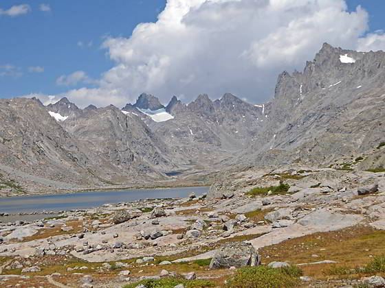
Cirque at the head of Titcomb Basin
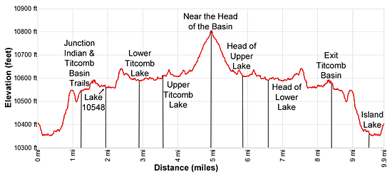
- Distance: 9.9 miles
- Elevation: 10,410-ft. at Island Lake
10,545-ft. at junction Indian and Titcomb Basin trails
10,548-ft. at Lake 10548
10,575-ft. at Lower Titcomb Lake
10,598-ft. at Upper Titcomb Lake
10,790-ft. near the Head of the Basin - Difficulty: moderate
- Basecamp: Green River Lakes
- Region: Wyoming's Wind River Range
Titcomb Basin Description
This hike starts from at the unmarked junction at the southeast end of Island Lake (10,346-ft.). The trail to the left (northwest) leads to campsites along the lake’s southwestern shore. The trail straight ahead (northeast) is the Indian Pass trail.
Follow the Indian Pass trail as it skirts the eastern shore of Island Lake. Along the way enjoy fine views of the summits towering above Titcomb Basin to the north. Elbow (11,948-ft.) and Sky Pilot (12,129-ft.) peaks rise in the distance to the northwest.
Pass an unmarked trail/route at 0.3 miles climbing to Pass 11120, a saddle on the ridge between the Island and Wall Lake basins. Soon our trail curves to the left (northwest) around the northeast lake shore and starts climbing.
At 0.7 miles the path curves to the right north and ascends the north side of a draw to a saddle on a low ridge at 0.9 miles. Atop the ridge are more great views of the summits of Titcomb Basin.
The trail now descends through meadows into a pretty basin cradling Lake 10,467. Pass above the lake’s eastern shore and then climb around a minor ridge at the northeast end of the lake, paralleling the lake’s inlet stream (the creek draining Indian Basin).
Reach the junction of the Indian Pass and Titcomb Basin trails at 1.2 miles. Here the trail to Indian Pass turns right (northeast). We continue straight ahead (north) on the Titcomb Basin Trail.
A short distance past the junction the trail crosses the stream draining Indian Basin by hopping across the large boulders that litter the creek bed. Beyond the crossing the trail traverses meadows and passes a small pond. The path now weaves through rock outcroppings as it ascends a hill to a gap strewn with large boulders. Squeeze through the gap and then climb over a low hump, emerging onto the rocky meadows at the foot of Titcomb Basin at 1.6 miles.
The long, stunningly beautiful basin is rimmed with 12,000- and 13,000-ft. peaks culminating in a cirque of jagged summits that include Mount Woodrow Wilson (13,502-ft.), the Sphinx (13,258-ft.), Twin Peaks (13,185-ft.), Bob’s Tower (13,040-ft.) and Miriam Peak (13,480-ft.). Snowcapped Gannett Peak (13,804-ft.), the highest point in Wyoming, is seen in the gap between Mt. Woodrow Wilson and the Sphinx. As you ascend the basin enjoy ever improving views of the cirque along with the peaks lining the basin’s eastern and western walls.
Travel is now easy as the trail skirts the eastern shore of Lake 10,548, reaching the northern end of the lake at 2.2 miles. Here the trail climbs a rocky knoll on moderate grades and then descends into the next lake basin. Ahead, views open to Lower Titcomb Lake (10,575-ft.) sprawled across the valley floor.
The path now traverses through meadows strewn with boulders along the lake’s eastern shore. To the west views open to Titcomb Needles. The rugged west facing slopes of Fremont Peak (13,745-ft.) loom over the trail to the east.
Reach the head of the lower lake at 3.3 miles. Cross the isthmus separating the upper and lower lakes, briefly traveling along the east side of the outlet stream for the upper lake before arriving at the southeastern shore of Upper Titcomb Lake (10,598-ft.) at 3.6 miles.
The trail now travels through rocky meadows and small talus fields along the east shore of the upper lake. Across the lake a waterfall, emanating from Summer Ice Lake (11,170-ft.), cascades down a rocky gully along Titcomb Basin’s western wall. The unseen lake lies in a small cirque formed by The Great Needle (12,714-ft.), Henderson Peak (13,115-ft.), American Legion Peak (13,205-ft.), Winifred Peak (12,775-ft.) and the Buttress (12,205-ft.). Along the east side of the basin Mount Sacagawea (13,569-ft.) towers overhead while the distinctive towers and spires of Mount Helen (13,620-ft.) dominate the east wall beyond the lake.
Pass the north end of the upper lake at 4.3 miles. Here the trail starts climbing on easy to moderate grades through meadows and then across large rock slabs. Rock cairns mark the trail across the slabs. The trail gets harder to follow as you near the head of the basin.
The open country invites exploration and is a photographer’s delight. Wander as far up valley as time and energy permit and then find a good perch to take in the views. When you are done absorbing the amazing scenery retrace your steps.
Backpacker looking to camp in Titcomb Basin will find the best sites to the south of Lower Titcomb Lake. Climbers typically setup camp in the upper basin, beyond the lakes. Finding a level campsite that is at least 200-ft. from trails and water is somewhat of a challenging. Hanging food is also problematic due to the lack of trees. You will need to find a large boulder to hang your food or carry a bear container.
Return to Segment 4: Indian Pass Trail to Island Lake
Go To Segment 5: Island Lake to Elkhart Park
Elevation Profile
Backpack Segments
- Introduction: Green River Lakes to Island Lake & out Elkhart Park
- Segment 1: Highline: Green River Lakes to Trail Creek Park
- Segment 2: Highline: Trail Creek Park to Elbow Lake
- --- Side Trip: Peak Lake
- Segment 3: Highline: Elbow Lake to Indian Basin Trail
- --- Side Trip: Island Lake Backdoor
- Segment 4: Indian Pass Trail to Island Lake
- --- Side Trip: Titcomb Basin
- --- Side Trip: Indian Basin and Pass
- --- Side Trip: Island Lake Waterfall Hike
- Segment 5: Island Lake to Elkhart Park
Driving Directions to Elkhart Park Trailhead
Green River Lakes Trailhead: Located just off the northwest shore of scenic Green River Lake, the trailhead offers access to several trails including the Highline Trail, which is part of the Continental Divide National Scenic Trail, Clear Creek Trail, and the Roaring Fork Trail.
Directions from Pinedale: From the intersection of Pine Street (US 191) and North Tyler Ave (the Pinedale Tourism office is located on the northeast corner) in Pinedale, WY, drive west on Highway 191 (West Pine Street) for 6 miles and then turn right on WY-352 toward Cora. Follow WY-352 for 25.3 miles to the National Forest boundary, where the pavement ends. Continue straight ahead on Green River Lakes Road (Forest Service Road 600). (Stay along the east side of the river, ignoring any roads branching to the left.)
Follow Green River Lakes Road for 18.5 miles to a signed intersection for the Green River Lakes campground and trailhead. The road to the right leads to the campground. We bear slightly left, staying on the Green River Lakes Road. Continue on the road for 0.2 miles and then turn left at the signed intersection for the trailhead parking area. Drive along the spur road for 0.1 miles to a “Y” intersection and turn right into the trailhead parking area. The road to the left leads to the equestrian parking lot. The trailhead is located at the southwest end of the parking area.
The 50 mile trip should take about 1 hour and 45 minutes. Passenger cars can typically make it to the trailhead. Check at the forest service office in Pinedale for current road conditions.
Elkhart Park Trailhead: From the intersection of Pine Street (US 191) and North Tyler Ave (the Pinedale Tourism office is located on the northeast corner) in Pinedale, WY, drive east on Highway 191 (East Pine Street) for 0.3 miles and bear left onto Fremont Lake Road. Follow this road for 14.3 miles and turn right into the large parking area for the Elkhart Park/Pole Creek Trailhead. After the first 3.0 miles the road will turn into Skyline Drive/Forest Service Road 370740. The trailhead is located at the northeast end of the parking lot between the outhouse and the trailhead kiosk. It should take about 25 minutes to drive the trailhead. The last section of the road has some holes and uneven spots.
Trail Resources
- Backpack Intro
- Segment Photo Gallery
- Segment Map
- Trailhead(s) Information: Green River Lakes
- Region Information: Wyoming's Wind River Range
- Other Hiking Regions in: Wyoming