Best Hikes in South Central Utah
Location: The south central portion of the state to the south of I70 and east of Utah 89 encompassing the Grand Staircase-Escalante National Monument, Capital Reef National Park and Bryce National Park.
Featured Hikes
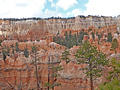
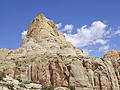
Figure 8 Loop - Queens Garden, Peek-a-boo and Navajo Trails ![]()
Distance: 6.4 miles (Loop)
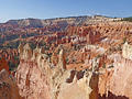
The best hike in Bryce, the Figure 8 Loop, combines the Queens Garden, Peek-a-Boo Loop and the Navajo trails for a memorable day with up-close encounters and epic views of an amazing variety of hoodoos, pinnacles and fins eroded into weird and wonderful formations.
Distance: 9.5 - 14.5 miles (Loop)
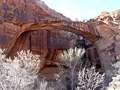
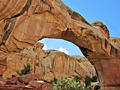
This amazing hike in Capitol Reef travels through a scenic canyon with eight arches and impressive rock formation and then climbs to and traverses the ridge atop Waterpocket Fold with panoramic views of the colorful ridge and surrounding area.
Distance: 5.0 miles (Loop)
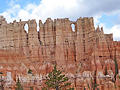
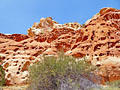
The Wall of Windows, the Cathedral and Fairy Castle along with terrific views of the Bryce Amphitheater and rock formation along Peek-a-boo Canyon are the rewards for completing this scenic loop trail. A steep descent and ascent from Bryce Point are required to reach to the loop.
Distance: 8.0 - 12.0 miles (Round Trip)
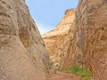
This fascinating walk down rugged Lower Spring Canyon features soaring sandstone walls, magnificent domes and two sections of twisting narrows. Minor obstacles add some challenge to the walk that starts by hiking a section of the Chimney Rock trail.
Navajo Knobs and Rim Overlooks ![]()
Distance: 4.5 - 9.4 miles (Round Trip)
Another great hike in Capitol Reef, the Navajo Knobs trail ascends along a bench with non-stop, birds-eye-views of some of the parks iconic landmarks along with impressive vistas of Waterpocket Fold. Distant views extend to the Henry Mountains and beyond.
Distance: 5.3 - 7.2 miles (Round Trip)
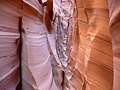
Beautiful Zebra Canyon, a narrow, convoluted slot streaked with pink and white stripes, will delight hikers of all ages. Combine the hike with nearby Tunnel Slot, a long narrow slot, for a great day hike down the Hole in the Rock Road.
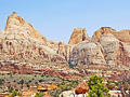
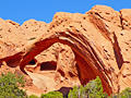
Cohab Canyon to Cassidy Arch via the Fryingpan ![]()
Distance: 6.0 - 8.6 miles (Round Trip)
Terrific panoramas atop Waterpocket Fold, a scenic canyon and a photogenic arch are the highlights of this amazing, albeit strenuous hike through a rugged landscape that incorporates portions of the Cohab Canyon, Fryingpan and Cassidy Arch trails.
Distance: 8.4 miles (Loop)
This terrific loop hike travels along the rim and then into Fairyland and Campbell Canyons with amazing views of multi-colored hoodoos, spires and fins. This path is more strenuous but less crowded than Bryce National Park’s other trails.
Distance: 5.0 - 14.0 miles (Round Trip)
This beautiful hike, one of my favorites in the Escalante area, travels through a gorgeous canyon beneath towering white Navajo and red Wingate sandstone walls.
Distance: 3.4 miles (Round Trip)
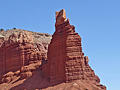
A steep climb up the north wall of Grand Wash leads to a spur trail that ascends to an overlook above photogenic Cassidy Arch, spanning a large chasm. The trail is quite scenic with fine views of the colorful sandstone formation in the heart of Capitol Reef.
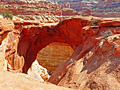
Distance: 8.8 - 10.4 miles (Round Trip)
This scenic hike visits an interesting arch set high atop the north wall of Phipps Wash. An optional extension travels to Maverick Bridge.
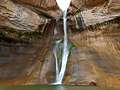
Distance: 5.8 miles (Round Trip)
This good introductory hike to the Escalante National Monument travels up a scenic canyon and leads to the base of lower Calf Creek Falls, a beautiful 126-ft. tall cascade.
Distance: 4.0 - 14.0 miles (Round Trip)
A scenic canyon with an interesting natural bridge, an arch, rock art and a small ruin make for a nice day hike in the Grand Staircase-Escalante National Monument.
Distance: 0.5 - 5.5 miles (One Way)
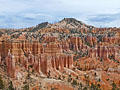
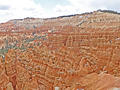
A walk along the Rim of Bryce Canyon offers unforgettable views of amphitheaters filled with multi-colored hoodoos, massive fins and eroded ridges. Along the way pass iconic formations such as the Wall of Windows, Silent City, Thors Hammer and Fairyland, to name a few.
Distance: 1.7 - 2.2 miles (Round Trip)
The short steep climbs leads to a colorful hanging canyon with sculpted, pockmarked walls that look like geological Swiss cheese. Short, narrow side canyons and two overlooks with views of the Fremont River Valley and Fruita add interest to the hike that ends at UT-Highway 24.
Distance: 2.0 - 3.1 miles (Loop)
Experience hiking through a maze of weird and wonderful rock formations in Bryce Canyon on the Queens Garden-Navajo Loop trail. The trail is the perfect option for hikers short on time or looking for an easier day.
Distance: 1.9 - 4.6 miles (Round Trip)
This short hike down a deep, scenic canyon features rock art, historic inscriptions, a narrows and large potholes (water tanks) along with some historic relics from when the canon was part of the main route through Capitol Reef.
Distance: 0.3 miles (Round Trip)
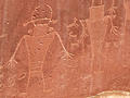
Short, easy walk along two boardwalks lead to interesting petroglyph panels carved into Wingate sandstone cliffs along the north side of the Fremont River valley.
Distance: 3.8 miles (Round Trip)
Ascend benches above Capitol Gorge to an overlook atop of Waterpocket Fold with great views of Golden Throne, an impressive tower, Capitol Gorge and the nearby formation in the heart of Capitol Reef.
Distance: 0.9 - 5.9 miles (Round Trip)
This scenic overlook atop Waterpocket Fold boasts breathtaking views of the Fold, Strike Valley, Tarantula and Swap Mesas, the Henry Mountain Mountains and Upper Muley Twist Canyon. The domes of Capitol Reef rise in the distance to the north.
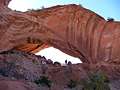
Distance: 1.8 miles (Round Trip)
This scenic hike to an impressive natural bridge features fine views of Navajo Dome, Capitol Dome and Pectols Pyramid. Along the way view the foundation of a pit house, spot a granary in a high alcove and discover a small natural bridge, a favorite with kids of all ages.
Distance: 1.5 - 7.6 miles (Round Trip)
Pleasant Creek Canyon, carved over millenniums by a lovely perennial stream, is a great place to explore. With no maintained trails, hikers follow routes leading up and down the canyon, along the way discovering rock art, narrows in side canyons and interesting formations.
Distance: 3.6 miles (Loop)
This scenic hike ascends the mesa above the Mummy cliffs to an overlook with fine views of the Chimney Rock formation. The path then curves around the mesa above the cliffs enjoying distant panoramic views of tilted Waterpocket Fold and Capitol Reef.
View Hikes by Area:
EscalanteBryceCapitol Reef
The Region, the Hikes & the Base Camps
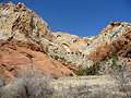
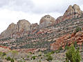
The 1.9 million acre Grand Staircase-Escalante National Monument, along with Capitol Reef National Park, Bryce National Parks, a variety of BLM lands and State Parks, protect large swaths of south central Utah. Numerous hiking trails penetrate this amazing landscape allowing hikers to wander through the stone forests formed by the pink and white hoodoos at Bryce National Park, to spend days roaming the vast and rugged plateaus and multi-hued cliffs of the Grand Staircase and Canyons of the Escalante and to explore the hidden treasures of the Waterpocket Fold and Cathedral Valley in Capitol Reef National Park.
Base Camp Information: Escalante / Bryce / Capitol Reef