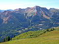
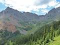
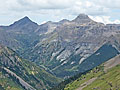
Best Hikes in Southwest Colorado
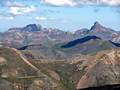
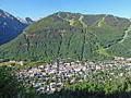
Location: 35 miles south of Montrose, 45 miles north of Durango and 70 mile northeast of Cortez, Colorado.
Featured Hikes
Distance: 8.0 - 12.7 miles (Loop)
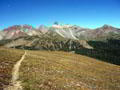
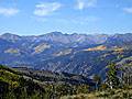
This is my favorite hike in Telluride. The trail crosses a high saddle separating two gorgeous alpine basins, traverses meadows filled with thigh-high wildflowers and serves up spectacular views of the high peaks surrounding the Telluride Valley and the San Miguel Mountains in the Lizard Head Wilderness.
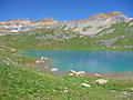
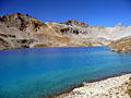
Distance: 7.8 - 8.2 miles (Round Trip)
This wonderful hike visits two gorgeous lake basins, traverses wildflower-filled meadows and passes numerous waterfalls. Dramatic peaks punctuate the ridge forming the backdrop for upper Ice Lake, nestled in an alpine wonderland that invites exploration.
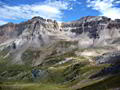
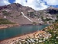
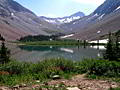
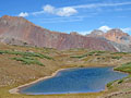
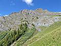
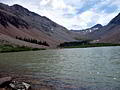
Blue Lakes and Blue Lakes Pass ![]()
Distance: 6.3 - 11.0 miles (Round Trip)
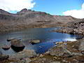
This popular hike visits three scenic lakes nestled in beautiful glacial basins set amid rugged ridges and peaks. Beyond the lakes the trail climbs to a dramatic pass on a ridge south of Mt. Sneffels (14,150-ft).
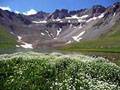
Distance: 2.3 - 5.4 miles (Round Trip)
This terrific hike wanders through beautiful American Basin, visits scenic Sloan Lake and then ascends to the summit of Handies Peak (14,048-ft.) with spectacular panoramic views of the San Juan Mountains.
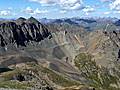
Distance: 7.8 miles (Round Trip)
Stunning panoramic views are the rewards for hiking to the top Uncompahgre Peak (14,309-ft.), the sixth highest fourteener in Colorado and the highest point in the San Juan Mountains.
Bear Creek National Recreation Trail ![]()
Distance: 4.4 - 8.0 miles (Round Trip)
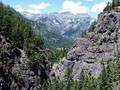
A dramatic trail carved into a steep cliff face high above Bear Creek is just one of the highlights of this hike up a beautiful canyon to two scenic mine sites.
Distance: 8.0 - 8.8 miles (Round Trip)
This scenic hike winds up Bridal Veil Basin past the historic Lewis Mill to Lewis Lake, nestled in a stark glacial basin at 12,700-ft. Along the way pass remnants of the area’s rich mining history, numerous waterfalls and hillsides filled with spectacular wildflowers displays.
Distance: 7.6 - 11.7 miles (Loop)
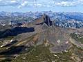
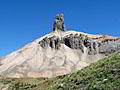
One of the top hikes in the Telluride area, this scenic loop traverses the panoramic spine of Blackface Mountain on its way to the base of Lizard Head Peak (13,113-ft.), an eroded 400-ft. tall spire shaped like the gaping maw of a lizard with its face to the sky.
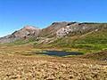
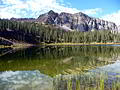
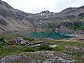
Cataract Lake (aka Cataract Gulch) ![]()
Distance: 4.2 - 10.0 miles (Round Trip)
Beginning in dense woods the trail passes cascades and waterfalls along Cataract Creek, travels through beautiful alpine meadows and visits a scenic alpine lake on its way to the Continental Divide.
Distance: 6.0 - 7.7 miles (Round Trip)
This trail ascends to gorgeous lakes set amid scenic alpine meadows with terrific views. An optional extension follows a segment of the Continental Divide, turning the hike into a loop with extended views of the surrounding peaks
Distance: 4.2 - 7.7 miles (Round Trip)
An old mining road leads to the heart of Spencer Basin, a beautiful, unspoiled and seldom visited valley surrounded by 13,000-ft. peaks. Here use trails and routes lead to two scenic passes.
Distance: 7.0 - 8.9 miles (Round Trip)
This little known hike climbs steeply through forest and beautiful alpine meadows to a stunning glacial lake set amid a backdrop of rugged 13,000-ft. peaks. Panoramic views from nearby Columbine Pass encompassing Bridal Veil Basin and the Sneffels Range.
Distance: 5.0 - 7.0 miles (Round Trip)
This scenic hike climbs to two pretty lakes in gorgeous Porphyry Basin. Along the way the trail travels through wildflower-filled meadows and passes waterfalls, interesting rock formations and mining ruins. The lovely alpine meadows of the upper basin offer several options for off-trail exploration.
Distance: 6.2 - 11.0 miles (Round Trip)
View of Dunsinane Mountain, Precipice Peak, Redcliff Peak and Coxcomb Peak accompany hikers on this long hike up the scenic Middle Fork Cimarron Valley. A final steep climb leads to Middle Fork Pass with spectacular views of Uncompahgre, Wetterhorn and Matterhorn Peaks.
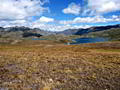
Spring Creek Pass East to Snow Mesa ![]()
Distance: 6.4 - 10.0 miles (Round Trip)
Hikers ascending from Spring Creek Pass to the beautiful, tundra-clad plateau of Snow Mesa are rewarded with glorious views of the San Juan Mountains to the west/southwest of the Lake City area. Extend the hike by climbing Baldy Cinco or walking to the ponds at the east end of the mesa.
Distance: 5.8 - 9.0 miles (Round Trip)
This trail wanders through wildflower-filled meadows and then climbs a gorgeous alpine basin to West Fork Pass. From the pass the trail drops into scenic Wetterhorn Basin with view of Wetterhorn Peak (14,015-ft.).
Distance: 9.0 - 11.8 miles (Round Trip)
A great hike leads to the top of two of the easiest fourteeners to climb in Colorado, Redcloud (14,034 ft.) and Sunshine (14,001 ft.) peaks. From the summits a sea of peaks and ridges extend in all directions, encompassing large swaths of the San Juan Mountains.
Distance: 12.3 miles (Round Trip)
Dramatic views of Bear Creek Canyon, beautiful alpine basins, wildflowers and waterfalls are a few of the delights on this steep trail to visit the saddle (13,050-ft.) on the divide between Bear Creek and Bridal Veil basins. The hike includes an initial 2.0-mile segment of the popular Bear Creek Falls trail.
Distance: 5.6 miles (Round Trip)
Stunning, birds-eye-views of the high peaks of the Telluride area are the reward for hikers making the steep climb to the summit of Ajax Peak.
Distance: 4.5 - 5.9 miles (Round Trip)
This popular hike to a high alpine lake surround by 13,000-ft. peaks offers panoramic views of the Wilson Range and the high peaks in the Lizard Head Wilderness.
Distance: 11.0 - 11.8 miles (Round Trip)
A scenic hike to a pretty lake nestled beneath North Twilight Peak (13,075). The hike can be extended by hiking to the saddle beyond the lake and/or scrambling to the top of North Twilight.
Distance: 9.2 miles (Round Trip)
This popular hike climbs through forest and meadows to a stark alpine lake basin surrounded by high peaks in the Lizard Head Wilderness.
Distance: 8.2 miles (Round Trip)
A stiff ascent through aspen groves, forest and meadows leads to pretty Crystal Lake set against the eastern slopes of Crystal Peak. Fine views encompass the vast tundra-clad plateaus to the east and the high peaks towering above Henson Creek to the south.
Distance: 5.1 - 6.3 miles (Round Trip)
Alpine meadows, far-reaching views and solitude are the hallmarks of this scenic trail that ascends Minnie Gulch to the Continental Divide Trail (CDT) and then follows the CDT in either direction (or both) accompanied by amazing, panoramic views. The hike can easily be shorten or extended.
Distance: 5.2 - 7.0 miles (Round Trip)
This pretty trail travels along an old mining road through three wildflower-filled basins accompanied by grand views of the Red Mountains towering above the west side of the Million Dollar Highway. Ruins of the Barstow and Greyhound mines add interest to the walk.
Distance: 6.0 - 7.6 miles (Round Trip)
Waterfalls, wildflowers and stunning views are the rewards for hikers making the stiff climb up Swamp Canyon to a high bench nestled below Ulysses S. Grant Peak. Extend the hike to Grant-Swamp Pass for breathtaking views of the Ice Lake area.
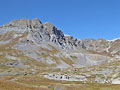
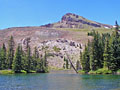
Pass Creek and Engineer Mountain ![]()
Distance: 4.8 - 12.8 miles (Round Trip)
This scenic hike, traveling through the high meadows to northwest of Coal Bank Pass, features terrific views of Engineer Mountain, Twin Sisters, the high peaks ringing the Cascade Valley and the summits rising to the south of Silverton.
Distance: 5.6 miles (Round Trip)
Terrific views of the high peaks towering above the Million Dollar Highway and Yankee Boy Basin are the rewards of this steep climb to a scenic pass to the south of Hayden Mountain.
Bridge of Heaven (via the Horsethief Trail) ![]()
Distance: 8.0 miles (Round Trip)
This well-engineered trail ascends 3,000-ft. to a knife-edge ridge with spectacular panoramic views.
Distance: 5.0 miles (Round Trip)
This great half day hike ascending Mesa Seco features splendid views of the San Juan Range rising to the west of the Lake City area along with the Slumgullion Earthflow, a huge, slow-moving landside that broke off the west side of mesa.
Spring Creek Pass West to Jarosa Mesa ![]()
Distance: 8.8 miles (Round Trip)
Hike a section of the Continental Divide/Colorado Trail from Spring Creek Pass to Jarosa Mesa for great views of the San Juan Range, including Uncompahgre Peak, Matterhorn Peak, Red Mountain, Redcloud Peak and Sunshine Peak.
Distance: 7.6 miles (Round Trip)
This gorgeous hike travels up a seldom visited valley to a scenic lake tucked in a high basin. Here you will experience a level of solitude not found on hikes to the nearby 14ers. Extend the hike by climbing to a saddle overlooking Lee Smelter Gulch to the north.
Distance: 8.0 miles (Round Trip)
The top of Handies Peak offers breathtaking views of the San Juan Mountains. This alternative route to the summit is longer and more strenuous but less traveled than the more popular trail to Handies Peak via American Basin.
Andrews Lake to Snowdon Peak Viewpoint ![]()
Distance: 2.2 miles (Round Trip)
This short hike ascends the slopes to the south of Andrews Lake, accompanied by fine views of the peaks to the north and west. The hike ends at a viewpoint with beautiful vistas of Snowdon Peak towering above a meadow clad bench with two small ponds.
Distance: 5.5 - 8.4 miles (Loop)
This interesting loop hike features panoramic views of Telluride, Bear Creek Canyon and the distant peaks of the Lizard Head Wilderness.
Distance: 6.8 - 8.2 miles (Round Trip)
This is a good hike for people looking for solitude and dramatic, up-close views of Mt. Sneffels. Don’t let the crowded parking lot deter you. Most hikers are headed for the Blue Lakes basin. You will have the Blaine Basin trail mostly to yourself.
Distance: 14.0 miles (Round Trip)
Picturesque groves of mature aspen and beautiful views of the Lake Fork Valley and Uncompahgre Peak are a few of the visual delights on this scenic trail following the Devil's Creek drainage to Devil's Lake, lying beneath the western flanks of the Calf Creek Plateau.
Distance: 5.0 - 6.6 miles (Round Trip)
Great views of the peaks rising above Ironton Park are the rewards for this stiff climb up the east facing slopes of Hayden Mountain. A traverse below the Hayden Ridge then leads to a route ascending to Peak 12,578 with terrific views of Yankee Boy Basin.
Distance: 6.0 miles (Round Trip)
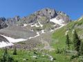
This nice hike up pretty Bridal Veil Basin leads past waterfalls and wildflowers to Blue Lake (12,220-ft.) nestled in a glacial cirque littered with mining relics.
Distance: 4.9 - 5.0 miles (Loop)
Trail Closed This scenic hike ascends a hand-laid trail to the summit of Hawn Mountain with terrific views of the Lizard Head Wilderness and the high peaks to the east and southeast of downtown Telluride.
Distance: 8.0 miles (Round Trip)
Iron Mountain climbs a steep mining road with fine views of the surrounding mountains along with Wilson Peak and the Lizard Head Wilderness. Aspen groves, waterfalls and an old mine add interest to the hike.
Distance: 7.8 miles (Round Trip)
A stiff climb leads to a scenic bench and a pretty lake high above the east side of the Lake City.
Distance: 4.6 miles (Round Trip)
This half day hike up Bear Creek Canyon offers scenic views of the rugged cliffs lining the canyon and ends at a pretty waterfall. It’s a nice option if you have limited time or just want an easy day.
Distance: 5.8 - 7.6 miles (Round Trip)
Ascend a scenic jeep road into the heart of Governor Basin, explore the Mountain Top mine ruins and then follow a route to an overlook with impressive views of the high peaks of Yankee Boy Basin.
Distance: 5.2 miles (Round Trip)
This nice half-day hike climbs on moderate to moderately-steep grades to a 12,450-ft. pass with panoramic views of the surrounding valleys and high peaks.
Distance: 7.8 - 9.6 miles (Round Trip)
An interesting hike through forest and meadows to a scenic lake basin nestled beneath the eastern escarpment of the Calf Creek Plateau (12,644-ft.) in the Powderhorn Wilderness.
Liberty Bell / Marshall Basin Loop ![]()
Distance: 6.0 - 10.6 miles (Loop)
This lightly traveled trail climbs steeply to Liberty Bell basin and a scenic ridge. Extend the hike by descending the Marshall Basin, scattered with mining ruins, on an off trail route to the Tomboy Mine and ghost town. Complete the loop by walking the Tomboy Road back to town.
Colorado Trail: Little Molas Lake to Lime Creek ![]()
Distance: 7.4 - 10.1 miles (Round Trip)
A moderately easy hike along a segment of the Colorado Trail featuring panoramic views from the high meadows above the West Lime Creek valley.
Distance: 3.2 miles (Loop)
This short, steep hike features fine views of Telluride along with the ski slopes and peaks rising to along the south side of the valley. The popular trail, used by locals for exercise and dog walks, is a good option for acclimatizing or if the weather precludes hiking in the high country.
Distance: 5.9 miles (Loop)
Ouray’s scenic Perimeter Trail circumnavigates the town, traversing cliffs, canyons and forested hillsides. Points of interest along the trail include Cascade Falls, the Baby Bath Tubs, the Amphitheater, the Uncompahgre River and Canyon Creek.
Distance: 3.5 - 4.2 miles (Round Trip)
This short, easy loop hike explores the basin below a huge amphitheatre of eroded cliffs rising above the eastern side of Ouray and features scenic viewpoints to appreciate the formation along with the peaks rising to the south and west of town.
Distance: 6.6 miles (Round Trip)
A nice hike to the base of Lizard Head Peak, a distinctive 13,113-ft. rock spire towering above Highway 145 just south of Lizard Head Pass.
Distance: 6.0 - 7.0 miles (Round Trip)
Nice views of Hayden Mountain, Whitehouse Mountain and the Uncompahgre River Gorge are the highlights of this hike up pretty Oak Creek Canyon to an overlook on the southern flank of Twin Peaks.
Distance: 6.8 - 7.9 miles (Round Trip)
The moderate hike to Baldy Peak features great views and an interesting perspective of the high peaks of the Ouray Region.
Distance: 5.6 miles (Round Trip)
Hikers completing the stiff climb to an overlook 3,000-ft. above Ouray are rewarded with panoramic views of Ouray, the amphitheatre and the sea of peaks and ridges rising to the east of town.
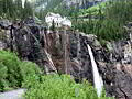
Upper Cascade Falls / Chief Ouray Mine ![]()
Distance: 4.4 - 5.9 miles (Round Trip)
This great half day hike climbing high above the eastern side of Ouray features fabulous views of the Uncompahgre Valley, Cascade Falls and the Amphitheatre.
Kilpacker Trail to Navajo Lake ![]()
Distance: 11.8 miles (Round Trip)
This alternative route travels through forest and then joins the Navajo Lake trail, a popular hike to a pretty alpine lake basin surrounded by high peaks. The combined route involves less elevation gain then the Navajo Lake trail but is 2.6 miles (round trip) longer.
Distance: 4.0 miles (Round Trip)
This hike ascends a jeep road and offers stunning views of Bridal Veil Falls, the tallest free falling waterfall in Colorado, the historic power plant at the top of the falls and the Telluride valley. The views are an added bonus for hikers who walk or drive up the road to reach the Bridal Veil trailhead leading to Blue Lake, Lewis Lake and other destinations in the Bridal Veil basin.
Distance: 2.3 miles (One Way)
The 2.25-mile unmarked Railroad Grade route, linking the Cross Mountain trailhead to the Lizard Head trailhead, enables hikers to complete a great 11.7 mile loop over Black Face Mountain to the base of the Lizard Head spire in the Lizard Head Wilderness. The walk may also be of interest to people looking for a nice easy stroll from the Lizard Head Pass parking area or the Cross Mountain trailhead.
| Support our Site |
The Region, the Hikes & the Base Camps
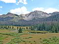
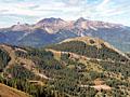
This guide showcases the best day hikes in one of Colorado’s best day hiking areas, the San Juan Mountains in southwestern Colorado around the towns of Ouray, Telluride, Silverton and Lake City. The San Juan Mountains encompass more than 10,000 square-miles of some of the most spectacular peaks, ridges and glacial valleys in the state. Sixteen peaks tower above 14,000-ft. and literally hundreds of summits top 13,000-ft. Three national forests and seven wilderness areas protect huge swathes of this amazing landscape.
The trails in this guide, best hiked between mid-July and mid-September, take you above the timberline to beautiful mountain lakes nestled in dramatic cirques, to passes with see forever views and to glorious alpine meadows filled with wildflowers. Round trip hiking distances range from 6 and 12.5 miles with elevation gains of 1,000– to 3,500-ft. Many of the trails offer great intermediate turnaround points for those seeking shorter hikes. All are reached in less than an hour drive from four great base camps; Ouray, Telluride, Silverton and Lake City.
Ouray, Telluride and Silverton are beautifully preserved Victorian era mining towns, each with its own distinct personality. The towns are linked by the stunning San Juan Skyway, a 233-mile scenic driving loop traversing the heart of the San Juan Mountains. Along the way the loop passes through Durango, Cortez and numerous historic sites.
A little further afield is Lake City, a small, remote Victorian town linked with Ouray and Silverton by the Alpine Loop National Backcountry Byway, a network of jeep roads traversing stunning scenery, visiting ghost towns and crossing passes up to 12,800-ft. Visitors driving regular passenger cars reach the idyllic little hamlet along Highway 149, aka the Silver Thread Scenic Byway, featuring some really beautiful scenery and a good dose of history.
Each town offers a range of accommodations, food and other essential services required by outdoor travelers.
Base Camp Information: Ouray / Telluride / Silverton / Lake City