Best Hikes in Lauterbrunnen
Location: Bernese Oberland
Lauterbrunnen Hiking Trails
Distance: 7.7 - 8.6 miles (One Way)
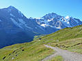
The best hike in Lauterbrunnen climbs steeply to Tanzbodeli, an overlook atop a grassy plateau with jaw-dropping, panoramic views of the high peaks towering above the Lauterbrunnen and Sefinen Valleys. The return via Obersteinberg is packed with visual delights.
Distance: 10.2 miles (One Way)
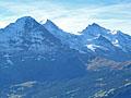
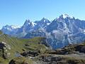
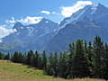
One of the best hikes in the Grindelwald area features fabulous views of the Bernese Alps stretching from the Wetterhorn, Eiger, Jungfrau and Breithorn, towering above the Grindelwald and Lauterbrunnen Valleys, to the Bluemlisalp massif in the southwest.
Distance: 10.8 miles (One Way)
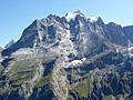
A triad of giants; the Eiger, Monch and Jungfrau, dominate the breathtaking views along this scenic hike from Mannlichen to Wengen.
Distance: 8.4 - 12.0 miles (Round Trip)
This beautiful walk showcases the high peaks soaring above the Lauterbrunnen and Sefinen valleys. The trail ascends through pretty meadows with nonstop views to Rotstock Hut and then climbs a wild valley to the Sefinenfurgge Pass where vistas open to the Kiental valley and beyond.
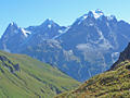
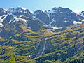
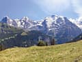
Murren to Griesalp via the Sefinenfurgge ![]()
Distance: 10.4 miles (One Way)
This splendid hike over Sefinenfurgge Pass, the second highest pass on the Alpine Pass Route, enjoys impressive views of the high peaks towering above the Lauterbrunnen, Sefinen and Kiental Valleys.
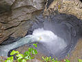
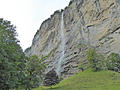
Lauterbrunnen to Trummelbach Falls ![]()
Distance: 2.2 - 4.4 miles (One Way)
This lovely walk up the Lauterbrunnen Valley travels through emerald green meadows and passes photogenic waterfalls on the way to Trummelbach Falls, a World Heritage Site. The dramatic falls are a true natural wonder, showcasing a series of waterfalls thundering down a slot canyon carved into a mountain.
Panoramaweg: Mannlichen to Kleine Scheidegg ![]()
Distance: 2.8 miles (One Way)
The Panoramaweg, between Mannlichen and Kleine Scheidegg, is an easy, popular hike with nonstop views the Eiger, Monch and Jungfrau. Extend the hike with a walk to the Mannlichen summit for more breathtaking views.
Distance: 3.5 - 5.0 miles (One Way)
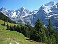
The Mountain View Trail, from Grutschalp to Allmendhubel to Murren, features stunning views of the Eiger, Monch and Jungfrau along with the glacier-clad peaks rimming the cirque at the head of the Lauterbrunnen Valley
Distance: 6.7 - 10.2 miles (Loop)
This loop hike travels to Obersteinberg, a pretty alp with impressive views of the glacier-clad summits rimming the head of the Lauterbrunnen Valley. Views stretch from the Jungfrau in the north to the Breithorn and Tschingelhorn in the south. Extend the hike with a trip to the Oberhornsee, a small lake.
Distance: 5.8 - 8.9 miles (Round Trip)
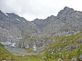
The Chilchbalm, a pretty glacial basin, lies beneath the rugged cirque at the head of the Sefinen Valley. The trail leading to the basin is perfect for anyone looking for a peaceful, relatively easy day hike accompanied by fine views of the Sefinen Lutschine (stream) and the rugged peaks rimming the Sefinen Valley.
Distance: 4.3 - 8.6 miles (One Way)
This easy hike travels up the enchanting Lauterbrunnen Valley, a classic glacial valley rimmed with sheer cliffs and soaring glacier-clad peaks, passing many beautiful waterfalls on its way to Stechelberg near the head of the valley. Lovely meadows, small alps and the Weisse Lutschine River add to the scenic delights.
Distance: 3.5 miles (One Way)
This short, easy walk along a high bench on the west side of the Lauterbrunnen Valley features terrific views of the big three: the Eiger, Monch and the Jungfrau, along with the Abeni Flue, Mittaghorn and the Grosshorn. The walk is a good option on a day when the weather precludes hikes at higher elevations.
View Hikes by Area:
Bernese OberlandGrindelwaldLauterbrunnenGriesalpKanderstegEngelbergMeiringenAltdorf
| Support our Site |