Best Hikes in Big Bend National Park
Location: Texas National Parks
100 miles south of Alpine, TX and 300 miles southeast of El Paso, the nearest large city.
Big Bend, located 100 miles south of Alpine, TX and 300 miles southeast of El Paso, protects a remote and spectacular wilderness that includes a large swath of the Chihuahuan Desert, the massive canyons along the Rio Grande and the Chisos Mountains, a rugged range in the heart of the park. Over 150 miles of trails explore this vast and unique landscape. View Big Bend Info
Introduction
Big Bend, located 100 miles south of Alpine, TX and 300 miles southeast of El Paso, protects a remote and spectacular wilderness that includes a large swath of the Chihuahuan Desert, three massive canyons along the Rio Grande and the Chisos Mountains, a rugged range in the heart of the park. Over 150 miles of trails explore this vast and unique landscape.
Big Bend Hiking Trails
Distance: 12.4 miles (Round Trip)
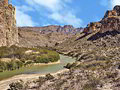
This long, strenuous hike features panoramic views of the Chisos Mountains and the Sierra Quemada range along with distant vistas of the high cliffs towering above the Rio Grande, the mouth of Santa Elena Canyon and nearby peaks in Mexico.
Distance: 10.0 miles (Round Trip)
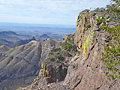
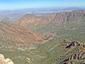
Hikers making the strenuous climb to the summit of Emory Peak are rewarded with stunning, panoramic views of Big Bend including the Chisos Range, the Rio Grande from Boquillas Canyon to Santa Elena Canyon, the Sierra Quemada and the vast Chihuahuan Desert.
Distance: 1.1 - 6.2 miles (Round Trip)
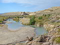
This beautiful trail travels through the Chihuahuan desert and along the rim of Hot Springs Canyon with terrific views of the Rio Grande, the Sierra Del Carmen Range and the Chisos Mountains. A visit to the Hot Springs Historic District adds interest to the hike.
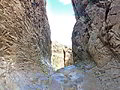
Distance: 1.4 miles (Round Trip)
Don’t miss this scenic hike to the mouth of Boquillss Canyon, a dramatic limestone gorge through the Sierra Del Carmen Mountains. Here the Rio Grande flows beneath the mountain’s soaring cliffs and rugged walls. Caves, fossils and grinding holes add interest to the hike.
Distance: 1.6 miles (Round Trip)
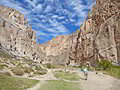
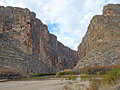
This short, popular trail features dramatic views of the Rio Grande flowing through the chasm formed by the sheer canyon walls of Santa Elena Canyon. From the high point along the trail vistas extend east to the Chisos Mountains and landmarks such as Mule Ears.
Distance: 2.0 - 4.8 miles (Round Trip)
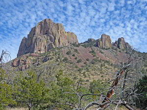
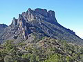
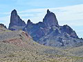
This popular hike ascends to Casa Grande’s scenic east ridge and then climbs atop the ridge extending northwest from Crown Mountain West for superb views of the Chisos Mountains along with Juniper and Pine canyons.
Distance: 3.5 - 7.2 miles (Round Trip)
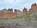
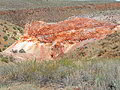
This trail visits the Homer Wilson Ranch and then ascends Blue Creek Canyon for 1.75 miles to an area of colorful red rock formations. Continue up the canyon for fine views of Peaks 6720 and 7150 before the trail makes a steep ascent to Laguna Meadows on the Chisos Rim.
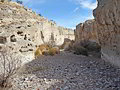
Distance: 11.0 - 14.0 miles (Round Trip)
This long, strenuous hike travels through an unforgiving desert landscape set amid the Dead Horse Mountains. Great views of the Sierra Del Carmen and Dead Horse Mountains, an intimate view of the desert and stunning Rio Grande vistas repay hikers for their efforts.
Distance: 7.2 - 8.8 miles (Round Trip)
This trail ascends to and then travels across Burro Mesa to an old corral, part of the Sam Nail Ranch. Hikers must then plot their own course to the ruins of an old cabin and the head of Apache Canyon for great views colorful rock formations composed of chert (flint).
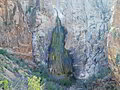
Distance: 3.2 - 5.8 miles (Round Trip)
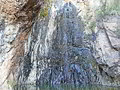
This hidden oasis in the desert is truly a special place. Here a spring fed waterfall trickles down an 80-ft. pour-off into a pool. The micro-ecosystem around the fall is a haven for wildlife and plants not typically seen in the desert. Some scrambling over boulders is required to reach the falls
Distance: 4.0 - 5.9 miles (Round Trip)
The Mule Ears Spring trail travels through classic Chihuahuan Desert terrain along the foothills to the south of Trap Mountain to a spring set amid a lush oasis of cottonwoods, shrubs, ferns and cattails. Extend the hike by continuing toward Smoky Creek for great views of Mules Ears Peak.
Distance: 2.2 - 6.4 miles (Round Trip)
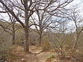
The Oak Spring trail features great views of the Window without the crowds. During wet periods a waterfall spills over the pour-off at the base of the Window. The hike is accompanied by panoramic views of the desert, Burro Mesa and the Chisos and Christmas Mountains.
Distance: 5.5 miles (Round Trip)
The Window trail, one of the most popular hikes in Big Bend, descends down Oak Creek Canyon to a dramatic, narrow gap in the high peaks surrounding the basin. A scenic canyon, narrow ravine and sheer red-rock walls add interest to the hike.
Distance: 1.1 miles (Round Trip)
This short hike visits two overlooks and then descends into Tuff Canyon, with walls composed of volcanic ash welded into rock. The walk up the canyon offers evidence of Big Bend’s volcanic past along with nice views of canyon and the surrounding area.
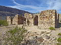
Distance: 1.0 miles (Round Trip)
This short interesting trail leads to the remains of four historic structures that were once part of the “Grand Canyon” farms operations. Fine views along the way include the Rio Grande, Santa Elena Canyon, the Chisos Mountains, Emory Peak and Mule Ears.
Distance: 0.4 miles (Loop)
This short loop trail explores the Sam Nail Ranch, set amid an oasis beneath Burro Mesa. The peaceful loop passes the ruins of the house, a chicken coop, an orchard and two wind mills and enjoys great views of the Chisos Mountains, the Window, Vernon Bailey and Carter Peaks.
View Hikes by Area:
Texas National ParksBig Bend