Best Hikes in The French Alps
Location: The French Alps extend for 112 miles from Lake Geneva on the Swiss border in the north to Nice and the Italian border to the south and are bounded by Switzerland and Italy to the east.
Featured Hikes
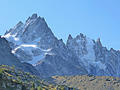
Grand Balcon Nord - Plan de l’Aiguille to Montenvers ![]()
Distance: 4.5 - 5.7 miles (One Way)
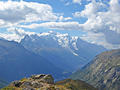
A high traverse along the Grand Balcon Nord features nonstop, panoramic views of Mont Blanc, the Chamonix Aiguilles, the Aiguille Rouges, Le Brevent and the Chamonix Valley. The hike ends at Montenvers with stunning view of the high peaks towering above the Mer Glacier.
Distance: 5.4 - 11.0 miles (Loop)
Enjoy amazing, nonstop views of Mount Blanc range on the strenuous loop hike climbing along the upper and middle slopes of the Aiguilles Rouges. The hike includes a stop at Lac Blanc, offering unparalleled views of the range.
Albert Premier Refuge and the Col de Balme ![]()
Distance: 6.4 - 6.6 miles (Round Trip)
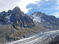
Up-close view of the Le Tour Glacier along with terrific views of Mont Blanc, the Aiguille Rouges, Aiguille du Chardonnet and Aiguille Verte are the rewards of this steep hiking climbing to the Albert 1st Refuge. Visit the Col de Balme on the return trip if time and energy allow.
Grand Balcon Sud – Planpraz to Flegrere ![]()
Distance: 3.5 - 7.0 miles (Round Trip)
A high level path along the slopes beneath the Aiguille Rouges features nonstop, breathtaking views of Mont Blanc range across the l’Arve Valley. Extend the hike with a trip to Lac Blanc.
Col du Balme and Aiguilles des Posettes ![]()
Distance: 6.8 miles (Round Trip)
The views are nonstop on this amazing hike visiting two panoramic summits, an incredible overlook and a scenic saddle on the Franco-Swiss border. After visiting the Col du Balme the hike is a roller coaster of ascents and descents. The views are worth the effort.
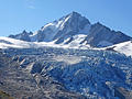
Argentiere Glacier and the Grand Balcon Nord ![]()
Distance: 3.0 - 6.9 miles (Round Trip)
Visit the Glacier d’Argentiere, an impressive spectacle of rock and ice flowing down a scenic valley rimmed by jagged peaks. An optional return route descends the Grand North Balcony accompanied by fine views of the Aiguilles Rouges and le Brevent.
Pierre a Berard Refuge and Col de Salenton ![]()
Distance: 6.6 - 9.4 miles (Round Trip)
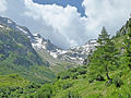
This hike ascends the Berard Valley (Vallon de Berard), a lovely, peaceful vale unspoiled by ski apparatus, to the charming Refuge Pierre a Berard. Beyond the refuge a very steep route climbs up granite outcroppings, boulders and scree to the Col De Salenton.
Les Houches to the Col de Tricot and Mont Vorassay ![]()
Distance: 4.8 - 13.8 miles (Round Trip)
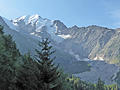
This interesting hike features fine views of Bionnassay and its glacier and Mont Blanc and the southern end of the Aiguille Rouges along with distant views of the Fiz range to the north and the Aravis range to the west.
View Hikes by Area:
Chamonix
The Region, the Hikes & the Base Camps
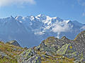
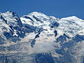
The French Alps, home to Mont Blanc -- Western Europe’s highest mountain, extend for 112 miles from Lake Geneva on the Swiss border in the north to Nice and the Italian border to the south and are bounded by Switzerland and Italy to the east. Spectacular scenery and marvelous mountain landscapes featuring snow-capped peaks, dramatic glacier and awe-inspiring waterfalls are just some of the highlights the regions has to offer.
Base Camp Information: Chamonix