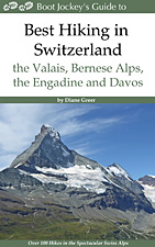
Best Hikes in Zermatt
Location: Valais
Zermatt Hiking Trails
Distance: 7.6 - 12.3 miles (Loop)
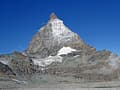
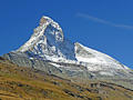
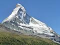
Our favorite hike in Zermatt features magical views of the majestic Matterhorn and stunning panoramas of the 4,000-meter peaks towering above the Zermatt area.
Gruben to Jungen via Augstbord Pass ![]()
Distance: 8.2 miles (One Way)
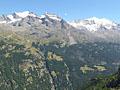
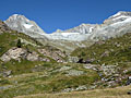
One of my favorite hikes in the Valais is the steep, scenic climb over Augstbord Pass leading to an overlook with stunning, panoramic views of the Bernese Alps and the high peaks towering above the Mattertal from Stalden to Zermatt.
Grachen to Saas Fee (Hohenweg Saas Fee) ![]()
Distance: 10.8 miles (One Way)
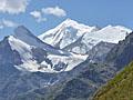
The Saas Fee Hohenweg is one of the classic hikes in the Valais. The challenging trail follows a high route along the west side of the Saastal with stunning, nonstop views of the glacier-clad peaks towering above the Saas Valley and the Bernese Alps to the north.
Schonbielhutte (Schonbiel Hut) ![]()
Distance: 13.7 miles (Round Trip)
Two great trails with terrific views of the Matterhorn are combined to create a fantastic hike to Schonbiel Hut, sitting atop a scenic overlook at the head of the Zmutt Valley.
Distance: 7.0 - 8.5 miles (Loop)
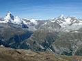
Great views accompany almost every step of this hike leading to Gornergrat, a glorious overlook with panoramic views of 20 peaks over 13,000-ft. (4,000-meters) high.
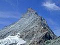
Distance: 5.6 - 10.5 miles (Round Trip)
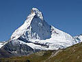
The short, steep hike to Hornlihutte offers a unique, up-close opportunity to experience the iconic Matterhorn from the base of the most popular climber’s route to the summit.
Distance: 4.1 miles (One Way)
Stunning, panoramic views of the Matterhorn and the summits rimming the Zermatt area are the highlights of this scenic hike through the stark landscape left by retreating glaciers. En route pass glacial lakes, colorful rock outcroppings and learn about the local geology.
Distance: 5.6 - 7.3 miles (One Way)
The Matterhorn is the star of the show on this scenic hike starting at Schwarzsee, a popular viewpoint atop the Matterhorn Plateau. Competing for your attention are splendid views of the high peaks rimming the Zmutt valley along with more distance views of the Findel and Monte Rosa areas.
Distance: 3.8 - 9.1 miles (Round Trip)
The second highest hiking trail in Switzerland leads to the summit of the Oberrothorn (11,200-ft.) with splendid, 360-degree views of 38 peaks over 13,000-ft. (4,000-meters).
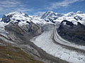
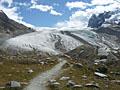
Gorner Gletschertor and Gletschergarten ![]()
Distance: 3.8 - 5.9 miles (One Way)
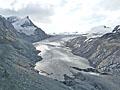
This trail ascends through larch forests and rocky meadows in the lower Gorner Valley, exploring the rugged terrain left by the receding Gorner Glacier. Information boards show the glacier’s progress over time and provide insights on the area’s geology.
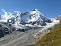
Distance: 7.8 - 8.6 miles (Round Trip)
This delightful hike leads to an overlook with front row seats to the amazing spectacle of massive rivers of ice flowing down the flanks of 4,000-meter peaks, joining with the Gorner Glacier to form the second largest glacial system in the Alps.
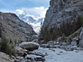
Distance: 4.5 miles (Round Trip)
This lovely hike climbs steeply up the beautiful Trift Gorge beside a cascading stream, traveling through lovely wildflower-filled meadows to the basin at head of the gorge surrounded by a gorgeous cirque of rugged peaks adorn with glaciers.
Distance: 5.8 miles (Loop)
Pretty meadows, larch forests and nice views of the Matterhorn make this trail a good option for families and hikers looking for a pleasant half day walk.
Distance: 5.4 - 8.3 miles (Round Trip)
This moderately-easy trail leads to a peaceful overlook with wonderful views of the Findel Glacier flowing down the slopes of the Cima di Jazzi. Along the way hikers enjoy splendid views of the Matterhorn.
View Hikes by Area:
ValaisZermattSaas FeeGrubenZinalLes HauderesArolla
| Support our Site |