Backpack: Green River Lakes to Island Lake & out Elkhart Park
Segment 1: Highline Trail: Green River Lakes to Trail Creek P
Distance: 14.3 miles (one way)
Bridger Wilderness, Bridger-Teton National Forest, near Green River Lakes in Wyoming's Wind River Range
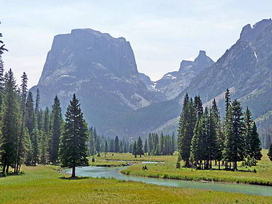
Beautiful view of Squaretop Mountain
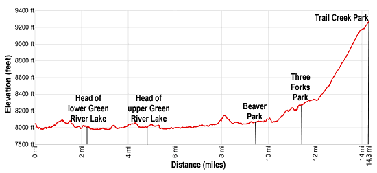
- Distance: 14.3 miles
- Elevation: 0.0 miles at Green River Lakes trailhead (8,040-ft.)
2.1 miles at head of Lower Green River Lake (8,000-ft.)
3.6 miles at foot of Upper Green River Lake (8,000-ft.)
9.5 miles at Beaver Park (8,080-ft.)
11.4 miles at Three Forks Park (8,240-ft.)
14.3 miles at Trail Creek Park (9,300-ft.) - Difficulty: moderate
- Basecamp: Green River Lakes
- Region: Wyoming's Wind River Range
Highline Trail: Green River Lakes to Trail Creek P Description
The Highline Trail starts at the southwest end of the Green River Lakes trailhead parking lot near an old cabin. Follow the trail as it curves to the left (east) and descends on easy grades through trees. Soon the horse trail joins from the left as the trail curves to the right and drops down to meadows along the northwest side of the Green River. Here views open to Squaretop Mountain (11,695-ft.), framed by the White Rock cliffs, rising to the east, and the high plateau formed by a trio of 11,000-ft peaks to the west.
In the meadows ignore the use trail branching right toward the lakeshore. At 0.3 miles the path briefly turns to the left (north) as it crosses a good wood bridge over the Green River and then curves back to the right (east/southeast), swinging around the foot of lower Green River Lake (7,961-ft.). In route, pass the old cabins from the historic Osborn homestead and the junction with the Highline Trail heading north toward the Roaring Fork Basin.
Along the east side of the lake the trail travels through a rolling landscape of grasslands and sage covered slopes scattered with aspen, cottonwood and pines trees. Squaretop Mountain dominates the view at the head of the lake while Sheep Mountain towers above the west side of the lake.
Enter the Bridger Wilderness at 0.7 miles and reach the southeast end of the lake at 2.1 miles. Beyond the lake the path skirts the edge of soggy meadows choked with willow thickets, passing the junction with the Clear Creek Canyon Trail branching left at 2.2 miles. We continue straight ahead on the Highline trail toward Three Forks Park.
At 2.3 miles the path crosses Clear Creek on a bridge and then travels through meadows along the edge of the forest before entering the trees at 2.7 miles. At 3.1 miles the trail passes a wood bridge spanning the Green River. We continue on the Highline Trail along the east side of the river.
Note: Crossing the bridge to the west side of the river leads to a 0.3 mile spur trail that heads west across meadows to a “T” intersection. At the intersection the Porcupine Trail to Porcupine Pass heads left (southeast) while the Lakeside Trail turns right (north/northwest) and travels along the west side of the lower Green River Lake, reaching the parking area in 2.8 miles. This is a nice option for a day hike. (Views from the Lakeside trail pale in comparison to the views along west side of the lake.)
Beyond the bridge the Highline swings to the left (east) and travels through trees and then lush grasslands above the north end of upper Green River Lake (7,968-ft.). Fine views extend south to Squaretop Mountain and the distinctive Bottle (11,457-ft.), a tower rising to the west of the Squaretop.
At 3.6 miles the path curves to the right (south) and begins a traverse through meadows and spruce-pine forest along the east side of the upper lake. The lake’s beautiful turquoise tint is the result of rock flour, fine grained silt suspended in glacial meltwater that flows into the lake.
Halfway along the lake the trail climbs over a rock outcropping. A few small streams trickle down the slopes above the trail. Near the head (south end) of the upper lake great views open to the limestone cliffs of White Rock towering above the east side of the lake. Reach the head (south) end of the upper lake at 4.75 miles.
Past the upper lake the trail skirts the forested fringe along the east side of the valley. The turquoise Green River meanders down emerald green meadows along the valley floor. Squaretop Mountain, flanked by the Bottle to the west, fills the skyline to the south.
At 5.9 miles the trail curves to the left (southeast) echoing the bend in the valley. The river twists and turns as it meanders down the valley floor, flowing around goosenecks and at time splitting temporarily into separate branches than soon rejoin. Squaretop soars above the valley floor.
At 6.9 miles the valley briefly constricts as the river and the trail pass between steep cliffs to the east and the timbered knobs to the north of Squaretop. Below the trail the river tumbles over rocks. Soon the valley reopens as the trail travels through timbered slopes above the east side of the river.
Begin a 120-ft. climb over a low bench jutting into the valley floor at 7.6 miles. As you ascend openings in the trees offer views of Squaretop’s rugged cliffs towering above the valley to the west. The trail returns to the valley floor at 8.3 miles.
At 8.6 miles the valley again briefly constricts as the trail is funneled between the river and rock ledges protruding from Peak 8,605 to the east. The steep slopes of Granite Peak (9,892-ft.), a timbered knob to the west of Squaretop, rise above the west side of the river.
Cross Elbow Creek and Pixley Creek on bridges at 9.2 and 9.3 miles respectively. Shortly after crossing Pixley views open to lovely Beaver Park. The north end of the park offers distant views of the high peaks towering above the head of the Green River Valley. Numerous campsites are located amid the trees and small meadows ringing the park, making it a popular place to spend the night along this section of the Highline.
Near the upper end of the park the trail crosses to the west side of the Green River on a wood bridge and then heads south, ascending on easy grades through spruce-pine forest along the west side of the valley. At 9.9 miles a bridge spans Marten Creek. A short distance beyond views briefly open as the trail skirts the edge of a boulder field before plunging back into the trees.
Reach beautiful Three Forks Park at 11.4 miles. The park is located just to the south of where Tourist Creek spills down a rocky gorge into the Green. The trail now travels through trees along the west side of the park.
The park is known for its lush, mosquito infested meadows and fine views of the rugged, unnamed peaks rimming the valley. Clusters of trees grow along the meandering course of the Green River. Campsites, scattered along the edge the park, are best used toward the end of the season when the mosquitos abate.
Near the head of the valley is the confluence of the Green River with the milky waters of Wells Creek, filled with rock flower. At the head of the park is a second confluence, where Trail Creek flows into the Green.
About midway along the park the trail swings away from the meadows and starts climbing on easy grades through the trees. The climb steepens at 12.4 miles as the trail turns to the right (southwest) and climbs a series of moderately steep switchbacks up the slopes to the northwest of Trail Creek.
The grade eases at 13.7 miles as the trail crosses Trail Creek. Logs and rocks will help keep your feet dry, except during periods of high water. On the east side of the creek the climb resumes on moderately-easy grades, reaching Trail Creek Park and the junction with the New Fork Trail at 14.3 miles.
At the junction the Highline Trail continues straight ahead (south) toward Summit Lake. The New Fork trail turns right (west), climbing to Clark and the Lozier Lakes. Near the junction a use trail head east to a nice camping area set amid meadows and clusters of trees. More campsites are found along Trail Creek. Remember to camp at least 100-ft. away from the creek.
Return to Introduction: Green River Lakes to Island Lake & out Elkhart Park
Go To Segment 2: Highline: Trail Creek Park to Elbow Lake
Elevation Profile
Backpack Segments
- Introduction: Green River Lakes to Island Lake & out Elkhart Park
- Segment 1: Highline: Green River Lakes to Trail Creek Park
- Segment 2: Highline: Trail Creek Park to Elbow Lake
- --- Side Trip: Peak Lake
- Segment 3: Highline: Elbow Lake to Indian Basin Trail
- --- Side Trip: Island Lake Backdoor
- Segment 4: Indian Pass Trail to Island Lake
- --- Side Trip: Titcomb Basin
- --- Side Trip: Indian Basin and Pass
- --- Side Trip: Island Lake Waterfall Hike
- Segment 5: Island Lake to Elkhart Park
Driving Directions to Green River Lakes Trailhead
Green River Lakes Trailhead: Located just off the northwest shore of scenic Green River Lake, the trailhead offers access to several trails including the Highline Trail, which is part of the Continental Divide National Scenic Trail, Clear Creek Trail, and the Roaring Fork Trail.
Directions from Pinedale: From the intersection of Pine Street (US 191) and North Tyler Ave (the Pinedale Tourism office is located on the northeast corner) in Pinedale, WY, drive west on Highway 191 (West Pine Street) for 6 miles and then turn right on WY-352 toward Cora. Follow WY-352 for 25.3 miles to the National Forest boundary, where the pavement ends. Continue straight ahead on Green River Lakes Road (Forest Service Road 600). (Stay along the east side of the river, ignoring any roads branching to the left.)
Follow Green River Lakes Road for 18.5 miles to a signed intersection for the Green River Lakes campground and trailhead. The road to the right leads to the campground. We bear slightly left, staying on the Green River Lakes Road. Continue on the road for 0.2 miles and then turn left at the signed intersection for the trailhead parking area. Drive along the spur road for 0.1 miles to a “Y” intersection and turn right into the trailhead parking area. The road to the left leads to the equestrian parking lot. The trailhead is located at the southwest end of the parking area.
The 50 mile trip should take about 1 hour and 45 minutes. Passenger cars can typically make it to the trailhead. Check at the forest service office in Pinedale for current road conditions.
Elkhart Park Trailhead: From the intersection of Pine Street (US 191) and North Tyler Ave (the Pinedale Tourism office is located on the northeast corner) in Pinedale, WY, drive east on Highway 191 (East Pine Street) for 0.3 miles and bear left onto Fremont Lake Road. Follow this road for 14.3 miles and turn right into the large parking area for the Elkhart Park/Pole Creek Trailhead. After the first 3.0 miles the road will turn into Skyline Drive/Forest Service Road 370740. The trailhead is located at the northeast end of the parking lot between the outhouse and the trailhead kiosk. It should take about 25 minutes to drive the trailhead. The last section of the road has some holes and uneven spots.
Trail Resources
- Backpack Intro
- Segment Photo Gallery
- Segment Map
- Trailhead(s) Information: Green River Lakes
- Region Information: Wyoming's Wind River Range
- Other Hiking Regions in: Wyoming