Best Hikes in Mineral King
Location: California's Southwestern Sierra
At the end of the Mineral King Road, 23.5 miles from Highway 198 and 55 miles from Visalia.
Mineral King is truly a special place to hike. The gorgeous valley is tucked in the southwestern corner of Sequoia National Park at the head of the East Fork of the Kaweah River surrounded by a stunning cirque. View Mineral King Info
Introduction
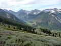
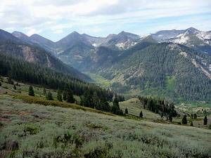
Mineral King (7,525-ft.) is truly a special place. The gorgeous valley is tucked in the southwestern corner of Sequoia National Park at the head of the East Fork of the Kaweah River. An elongated cirque of peaks, towering over 11,000-ft., rise above the valley floor. Steep, scenic trails ascend from the valley to glistening lakes, beautiful alpine meadows and stunning passes with panoramic views.
The steep winding road leading to Mineral King serves as a deterrent for casual visitors, limiting the number of people visiting this peaceful valley. Services in the valley are severely limited to nonexistent. Plan on being totally self sufficient, stock up on food and gas and check your gear twice to make sure you have everything you need before you start up the road.
Mineral King Hiking Trails
Distance: 6.4 miles (Round Trip)
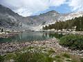
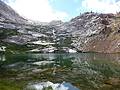
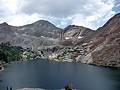
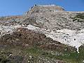
This short, strenuous hike climbs to a pretty lake nestled in a rugged cirque, with great views of the East Fork Kaweah River valley and the Great Western Divide en route.
Distance: 9.0 miles (Round Trip)
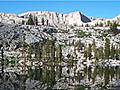
Beautiful Monarch Lakes lie cradled in scenic bowl at the foot of Sawtooth and Mineral Peaks. A moderately-steep trail to the lake climbs through meadows, red fir forest and avalanche-scoured slopes and features fine views of the Mineral King valley.
Distance: 12.0 miles (Round Trip)
This popular day hike climbs to Lower Franklin Lake, nestled in a scenic basin beneath the Great Western Divide.
Distance: 7.4 - 9.2 miles (Round Trip)
Multi-hued rugged canyon walls, pretty meadows sprinkled with wildflowers and a dramatic glacial cirque are the scenic delights of this great hike up White Chief Canyon
Distance: 7.2 - 9.0 miles (Round Trip)
This trail follows the path to Eagle Creek for the first 2 miles and then crosses Miner’s Ridge to the Mosquito Lake #1, a small, shallow lake surrounded by red firs. A use trail leads to Lake # 2, a beautiful alpine gem cradled in a granite basin. Use trails and cross-country routes climb the rocky basin to the other three lakes.
Distance: 4.5 miles (Round Trip)
This very steep hike offers great views of the Mineral King Valley and a good workout.
View Hikes by Area:
California's Southwestern SierraLodgepoleMineral King
Around Town
In 1873 James Crabtree discovered silver in the Mineral King’s White Chief Canyon. Over the next seven years prospectors came to the valley hoping to strike it rich. By 1880 winter avalanches and unprofitable mines brought an end to mining in the valley.
Thankfully others saw the real riches Mineral King had to offer and declared the area part of the Sierra Forest Preserve in 1893. Around the turn of the century, the forest service started leasing land for recreational cabin sites, creating small summer communities in Cabin Cave, Faculty Flats and East Mineral King/Beulah.
The area was threatened once more in the 1960’s and 1970’s, when the Walt Disney Corporation tried to build a ski resort in the valley. A bitter battle broke out between preservationist and pro-development groups that led to lawsuits. The matter was finally settled in 1978 when Congress added the valley to Sequoia National Park.
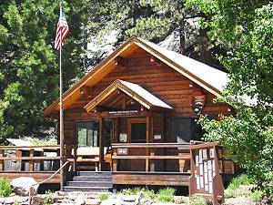
Today, anyone standing in the beautiful valley beneath its soaring peaks will be glad for those who fought so hard to preserve this amazing place. To see what could have happened stop in the Mineral King Ranger Station along the Mineral King Road, 24 miles from the junction with Highway, to view pictures and diagrams of the proposed ski area. The ranger station also includes historic photos of the area and a small collection of artifacts.
Needless to say the Ranger Station (559-565-3768) is a great place to get advice and learn about current trail conditions, purchase books and maps, rent bear canisters and pickup overnight backpacking permits. Advanced reservations are available for permits. See the Sequoia-Kings Canyon Wilderness permits page for more information. Note: the station typically does not open until late May.
The Cold Springs Nature trail, starting in the Cold Spring Campground across from the Ranger Station, is an easy two mile (out and back) trail with interpretive exhibits explaining the natural history of the valley. The trail travels up the valley, from the Cold Spring Campground to the Eagle-Mosquito Creek parking area.
For another nice, easy walk start at the end of the road and follow the Farewell Gap/Franklin Lakes trail for a mile or two up the beautiful East Fork Kaweah Valley. A good turnaround point is the pretty waterfall on Franklin Creek, 1.9 miles up the valley. See the Franklin Lakes trail description for more information on the trail and directions to the trailhead.
When visiting the valley during the spring and early summer be sure to protect your vehicle from the area’s marmot population. This might sound like a joke but it is a really problem. These cute little rodents have developed a taste for car parts. Enough damage can be done to disable a vehicle. Talk to the rangers to find out if marmots are likely to be a problem during your visit, which parking areas are affected and how you can protect your car. Some backpackers use tarps or chicken wire to keep the rodents at bay.
Nearby Attractions
When traveling to Mineral King half the adventure is truly just getting there. The 24.5 mile narrow, twisting road gains almost 7,000-ft as it climbs steeply up the north side of the East Fork of the Kaweah valley. The road travels along steep drop offs, in many places it is barely wide enough for two cars to pass and contains a few unpaved, bumpy sections. It is said that the road has almost 700 curves and I believe it. When driving it seems like one blind curve follows another.
To reach Mineral King from Visalia, CA, follow Highway 198 East for 31.5 miles to the Mineral King Road and turn right. (There is a small green sign by the side of the road that reads, “Mineral King 25 miles.”) It will take 1.5 hours to travel from the junction at Highway 198 to the ranger station (22.7 miles). The road is not recommended for RV’s or travel trailers.
Tulare County owns and maintains the first 9.6 miles of the Mineral King road. Beyond this point you enter the Sequoia National Park and soon arrive at Lookout point (10.3 miles), with a self service pay station. This is a great spot to get out of the car, stretch your legs and enjoy an excellent view up the canyon.
Reach the first of two campgrounds, Atwell Mill with 25 sites, at 18.7 miles. The campground is located above the site of a defunct sawmill. You can see the remains of the mill’s large steam engine near some giant sequoia stumps in a clearing across from the Atwell Mill Ranger residence.
Between campsites 16 and 17 is the beginning of the Atwell-Hocket Trail. A nice 5 mile (round trip) hike follows the trail, descending past the site of the old sawmill and then through forest to a scenic bridge crossing the East Fork Kaweah River. On the other side ascend along the trail through the East Fork Grove of giant sequoias.
A short distance back down the Mineral King Road from the campground is the start of the Paradise Peak trail. Walk up the moderately steep trail for about 1.5 miles to see giant sequoias in the upper section of the Atwell Grove. The grove was partially logged in the 1980’s. It continues onto Paradise Ridge, giving it the highest elevation of any sequoia grove. From the grove a very steep unmaintained trail climbs to Paradise Peak (10 miles round-trip hike from the trailhead).
Just before reaching the Silver City Resort (19.9 miles) you will pass Cabin Cove, a group of six summer cabins. Silver City Resort rents out cabins and chalets and includes a small restaurant and tiny store. The store stocks some basic camping supplies, snacks and soda. (Do not depend on the store to have the supplies you need. Make sure you are self sufficient before leaving Visalia.)
Pass Faculty Flats, a summer community of about 30 cabins, at 22.3 miles. The cabins were built in the 1920’s and many are on the National Register of Historic Place.
About a half mile further up the road is the Mineral King Ranger Station and the Cold Springs campground (40 sites). The Cold Springs Nature trail, described above, starts in the campground.
Continuing up the road you will pass the Tar Gap parking area, the Sawtooth / Monarch Lake trailhead parking areas and a number of cabins before reaching the end of the road at 23.5 miles. At the end of the road is the start of the Eagle Lake, Mosquito Lake and White Chief Canyon trails. A short distance back down the road is the beginning of the Farewell Gap and Franklin Lakes trails. Around the trailhead parking area is another group of 24 summer cabins, referred to as East Mineral King or the Beulah Tract.
Food, Lodging and Services
As previously mentioned visitors to Mineral King should be self sufficient. Bring all the food, camping supplies and other gear you need for your trip. There is NO gas. Cell phones don’t work in the valley. There are public pay phones available at the ranger station and the Sawtooth trailhead.
Two campgrounds at Mineral King, Atwell Mill and Cold Spring operate on a first-come, first serve basis with no reservations. Atwell Mill (21 sites) is 18.7 miles from the junction with Highway 198 and is situated along the East Fork of the Kaweah River at the site of a former logging operation. Cold Spring (40 sites) is located 22.7 miles from Highway 198 and set amid aspens and conifers across from the Ranger Station.
Silver City Resort (19.9 miles from Highway 198) is privately owned and offers a variety of cabins and chalets. The resort includes a restaurant, typically opened Thursday to Monday during the busy summer season, and a tiny store with very few supplies (mostly soda and snacks). There is no ice or gas. The restaurant does sells a variety of delicious pies and makes a very good cup of coffee.