Best Hikes in Bryce National Park, Utah
Location: South Central Utah
Located off of Utah Scenic Byway 12, 80 miles east of Cedar City , UT, 125 miles northeast of St. George, UT, 270 miles north east of Las Vegas, NV and 270 miles south of Salt Lake City, UT.
Bryce Hiking Trails
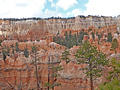
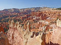
Figure 8 Loop - Queens Garden, Peek-a-boo and Navajo Trails ![]()
Distance: 6.4 miles (Loop)
The best hike in Bryce, the Figure 8 Loop, combines the Queens Garden, Peek-a-Boo Loop and the Navajo trails for a memorable day with up-close encounters and epic views of an amazing variety of hoodoos, pinnacles and fins eroded into weird and wonderful formations.
Distance: 5.0 miles (Loop)
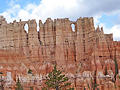
The Wall of Windows, the Cathedral and Fairy Castle along with terrific views of the Bryce Amphitheater and rock formation along Peek-a-boo Canyon are the rewards for completing this scenic loop trail. A steep descent and ascent from Bryce Point are required to reach to the loop.
Distance: 8.4 miles (Loop)
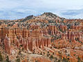
This terrific loop hike travels along the rim and then into Fairyland and Campbell Canyons with amazing views of multi-colored hoodoos, spires and fins. This path is more strenuous but less crowded than Bryce National Park’s other trails.
Distance: 0.5 - 5.5 miles (One Way)
A walk along the Rim of Bryce Canyon offers unforgettable views of amphitheaters filled with multi-colored hoodoos, massive fins and eroded ridges. Along the way pass iconic formations such as the Wall of Windows, Silent City, Thors Hammer and Fairyland, to name a few.
Distance: 2.0 - 3.1 miles (Loop)
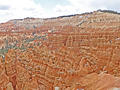
Experience hiking through a maze of weird and wonderful rock formations in Bryce Canyon on the Queens Garden-Navajo Loop trail. The trail is the perfect option for hikers short on time or looking for an easier day.
View Hikes by Area:
South Central UtahEscalanteBryceCapitol Reef