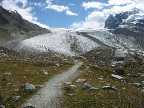
Approaching the Gorner Glacier Viewpoint
This delightful hike leads to an overlook with front row seats to the amazing spectacle of massive rivers of ice flowing down the flanks of 4,000-meter peaks, joining with the Gorner glacier to form the second largest glacial system in the Alps.
See Trail Detail/Full Description
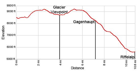
- Distance: 3.9 miles (one way) to Gorner Glacier Viewpoint
8.6 miles (round trip) to Complete Hike back to Riffelalp - Elevation: 8,471-ft. at Trailhead
8,670-ft. at Gorner Glacier Viewpoint
7,254-ft. at Complete Hike back to Riffelalp - Elevation Gain: 782-ft. to Gorner Glacier Viewpoint
-2,000-ft. to Complete Hike back to Riffelalp - Difficulty: moderate
- More Hikes in:
Zermatt / The Valais
Why Hike Gorner Glacier Viewpoint
The Gornergletscher (Gorner Glacier) viewpoint offers a unique opportunity to get up close and personal with the second largest glacial system in the Alps. The lookout, perched atop a grassy knoll on a moraine wall, offers bird’s-eye view of the convergence of two massive rivers of ice, the Gorner and Grenz Glaciers, spilling down the flanks of Monte Rosa.
Towering above this spectacle of ice are the Monte Rosa, Liskamm and Breithorn massifs along with Castor, Pollux and the Klein Matterhorn, capped in snow and ice. The tributaries of the Gorner Glacier; the Grenz, Monte Rosa, Zwillings and Schwarze glaciers, spill down the slopes of these peaks, combining with the Gorner Glacier to form an imposing glacial river flowing in motionless waves down the Gorner Valley.
Further down the valley the Breithorn, Triftji, and Unterer Theodul glaciers, former tributaries of the Gorner Glacier, no longer reach the valley floor but instead hang from the flanks of the Breithorn and Klein Matterhorn. Completing the scene the majestic Matterhorn stands alone, rising to the west of the Gorner Valley.
The hike to the viewpoint, starting at Riffelberg, is filled with scenic delights. The Gornergrat Cog Railway and an extensive network of trails allow hikers to tailor their day and modify itineraries on the fly. This description includes return routes to Riffelberg, Riffelalp (recommended) and Zermatt.
Get an early start on this hike. In the afternoon clouds often move in, covering the tops of the peaks and obstructing the views.
Elevation Profile
| Support our Site |
Trail Resources
Trail Detail/Full Description / Trail Photo Gallery / Trail Map
Basecamp(s) Information:
Zermatt
Region Information:
The Valais
Other Hiking Regions in:
Switzerland