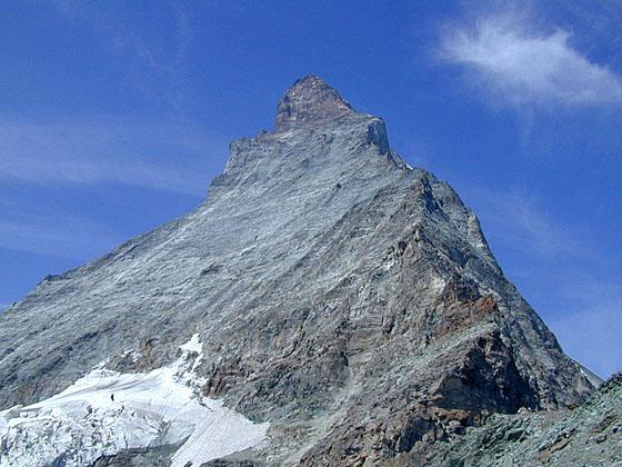
Looking up at the Matterhorn from the spot just above the hut
The short, steep hike to Hornlihutte offers a unique, up-close opportunity to experience the iconic Matterhorn from the base of the most popular climber’s route to the summit.
See Trail Detail/Full Description
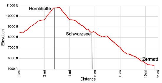
- Distance: 10.5 miles (round trip) to Hornlihutte
- Elevation: 8,490-ft. at Trailhead
10,695-ft. at Hornlihutte - Elevation Gain: 2,205-ft. to Hornlihutte
- Difficulty: strenuous
- More Hikes in:
Zermatt / The Valais
Why Hike Hornlihutte (Hornli Hut)
People flock to Zermatt to see the Matterhorn, probably the most photographed mountain in the world. Excellent overlooks along many of Zermatt’s popular hiking trails showcase the iconic peak from multiple perspectives.
But if you really want an up close and personal experience with the mountain there is no better hike than the trail to Hornlihutte (Hornli Hut). After viewing the Matterhorn from afar it is truly amazing to stand directly beneath this majestic peak and gaze up at its north and east faces soaring above the hut. With binoculars it is possible to watch climbers tackling the Matterhorn’s northeast ridge known as the Hornligrat – considered the easiest and most popular route to the summit.
Beside the spectacular views of the Matterhorn, the area around the hut offers marvelous views of the high peaks surrounding Zermatt. Across the valley to the north a wall of 4,000-meter peaks, from Dent Blanche to the Weisshorn, fill the skyline. The Mischabel Range towers above Zermatt to the northeast. To the southeast an incredible spectacle of peaks and glaciers along the Swiss-Italian border, including Monte Rosa, Lyskamm and the Breithorn, dominate the view. Nearer at hand to the west is the Matterhorn Glacier, clinging to the ledges along the peak’s north face.
Be forewarned that Hornlihutte trail is a very popular and quite crowded. I advise getting an early start to avoid the worst of the crowds and to get the best views of the peak. The Matterhorn is famous for its banner cloud, which is more likely to form and grow larger as the day progresses.
Do not take the trail to Hornlihutte in bad weather or if bad weather is imminent. Most of the trail is quite exposed and the steep sections of the trail can be problematic without the proper equipment when covered with ice or slick snow.
Elevation Profile
| Support our Site |

Trail Resources
Trail Detail/Full Description / Trail Photo Gallery / Trail Map
Basecamp(s) Information:
Zermatt
Region Information:
The Valais
Other Hiking Regions in:
Switzerland