Details: Little Lakes Basin 
Distance: 4.2 - 7.7 miles (round trip)
John Muir Wilderness Area, Inyo National Forest, near Mammoth Lakes in California's Southeastern Sierra
Hike Facts
- Distance: 4.2 - 7.7 miles (round trip)
- Elevation: 10,200-ft. - 11,110-ft.
- Elevation Gain: 360-ft. - 910-ft.
- Difficulty: easy-moderate
- Trail Highlights: See Trail Intro
- Basecamp(s): Mammoth Lakes / Bishop
- Region: California's Southeastern Sierra
A wonderful hike visiting a series of scenic lakes nestled in a gorgeous valley surrounded by 13,000-ft peaks. Side trips lead to Morgan and Mono Passes along with a number of other lakes.
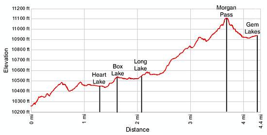
Trailhead to Long Lake
Distance from Trailhead: 4.2 miles (round trip)
Ending/Highest Elevation: 10,560-ft.
Elevation Gain: 360-ft.
From the Mosquito Flats parking area head south, ascending on gentle grades along the west side of Rock Creek. In a short distance the grade steepens as the trail climbs a small hill above Mack Lake. The lake is tucked below the trail in a gully and is difficult to see from the trail.
At the top of the hill reach a trail junction at 0.5 miles. Veer left in the direction of Morgan Pass to reach the Little Lake Valley. The trail to the right (west) climbs to Mono Pass.
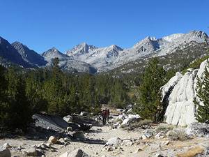
Just beyond the junction the trail crests the top of the hill and starts a moderate descent to the south end of Mack Lake. Along the way great views open to the high peaks ringing the Little Lakes Valley, including Mt. Morgan (13,748-ft.), Pyramid Peak (12,866-ft.), Bear Creek Spire (13,740-ft.), Mt. Dade(13,600-ft.), Mt. Abbot (13,704-ft.) and Mt. Starr (12,835-ft.).
For the next 0.7 miles the trail wanders through a gentle rolling landscape of meadows and scattered pine forest past the distant shores of Marsh Lake at 1.0 mile and the glistening waters of Heart Lake at 1.3 miles. As you progress up the valley enjoy every improving views of the stunning granite peaks towering above the head of the valley. Mt. Starr rises above the trail to the west while Mt. Morgan dominates the skyline to the east.
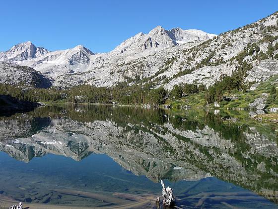
Beyond the south end of Heart Lake the trail ascends a hillside paralleling the western shore of Box Lake and arrives at a scenic overlook at 1.6 miles. Pyramid Peak, Bear Creek Spire and Mt. Dade tower above the cirque at the head of the valley. After a brief descent the trail resumes its gentle climb up the valley, crosses Rock Creek at 1.9 miles and arrives at the northern end of photogenic Long Lake at 2.1 miles.
From the north shore of the aptly named Long Lake, the jagged profiles of Mt Abbot and Bear Creek Spire fill the skyline to the southwest. Follow the trail as it traverses the lake’s eastern shoreline for 0.4 miles. Be sure to turn around for great views of Mt. Starr.
To Morgan Pass
Distance from Trailhead: 7.4 miles (round trip)
Ending/Highest Elevation: 11,110-ft.
Elevation Gain: 900-ft.
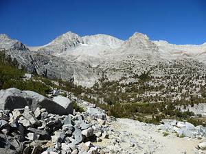
At the south end of Long Lake the trail ascends a granite bench on moderate grades, gaining 320-ft. over 0.7 miles. Along the way the trail passes a spur trail to Chicken Foot Lake at 2.75 miles and crosses a draw. The grade abates at 3.1 miles. If you look carefully through the trees to the southeast you will see the trail climbing to Morgan Pass. Rock hop across the outlet stream for the Gem Lakes and reach a trail junction at 3.4 miles. The trail to the right (southwest) heads to the Gem Lakes while the trail to the left (east) ascends to Morgan Pass.
If you have the time and energy I suggest visiting both destinations. The broad rocky trail to the pass ascends on moderately steep switchbacks, gaining 200-ft in 0.3 miles. As you climb look to the northwest toward the amazing sheer granite ridge extending north from Mt. Mills (13,451-ft.).
Morgan Pass (11,110-ft.), reached 3.7 miles from the trailhead, enjoys stunning views of Mount Dade, Mt Abbot and Treasure Mountain towering above the Gem Lakes basin. Steep scree covered slopes rise above a narrow valley to the east of the pass where the trail descends through a massive boulder field to Upper Morgan Lake (10,940-ft.) in half a mile and Lower Morgan Lake (10,700-ft.) in a mile. The trail eventually leads to the Pine Creek trailhead.
To Gem Lakes
Distance from Trailhead: 7.7 miles (round trip)
Ending/Highest Elevation: 10,930-ft.
Elevation Gain: 730-ft.
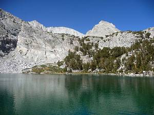
After taking in the views from the pass return to the trail junction and turn left (southwest) on the Gem Lakes trail. The trail heads west, passing through a pretty meadow along the south shore of one of the small Gems. Mount Dade, Mt Abbot and Treasure Mountain rises above the headwall at the west end of the basin. Mt. Starr rises in the distance to the north.
Beyond the small tarn the trail wanders through scattered pines, scrub growth and granite outcroppings to the east shore of the largest Gem Lake. This beautiful alpine jewel lies cradled in a granite bowl surrounded on three sides by steep granite cliffs. The tops of Mount Dade, Mt Abbot and Treasure Mountain peak above the granite ridge to the west.
After taking in the views return to the trail junction and retrace your steps down the Little Lakes Valley, enjoying a different perspective on the spectacular scenery during the hike back to the trailhead.
Elevation Profile
Driving Directions
From Mammoth Lakes: Drive east on Main Street / CA 203 E for 3.1 miles and turn right onto the entrance ramp for Highway 395 S. Follow Highway 395 S for 15 miles to Tom’s Pace (aka Rock Creek Road). Turn right (south) on Rock Creek Road and drive 10.5 miles up the canyon to the Mosquito Flats Parking area at the end of the road. The final 1.25 miles of the road is single lane with occasional pullouts. The trailhead is located at the south end of the parking lot.
From Bishop: Follow Highway 395 N north for 24 miles to Tom’s Place (aka Rock Creek Road). Turn left (south) on Rock Creek Road and drive 10.5 miles up the canyon to the Mosquito Flats Parking area at the end of the road. The final 1.25 miles of the road is single lane with occasional pullouts. The trailhead is located at the south end of the parking lot.
This trailhead is extremely popular and the parking area fills early in the morning (8:30am-9am). Overflow parking is available 0.3 miles back down the road. On busy weekends you may need to drive much further back on the road to find an empty parking space.
Trail Resources
Trail Intro / Trail Photo Gallery / Trail Map
Basecamp(s) Information:
Mammoth Lakes / Bishop
Region Information:
California's Southeastern Sierra
Other Hiking Regions in:
California