Backpack: New Fork Lakes to Island Lake & out Elkhart Park
Side Trip: Island Lake Waterfall Hike
Distance: 2.7 miles (loop)
Bridger Wilderness, Bridger-Teton National Forest, near New Fork Lakes in Wyoming's Wind River Range
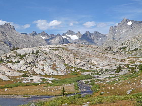
Titcomb Basin view
- Distance: 2.7 miles
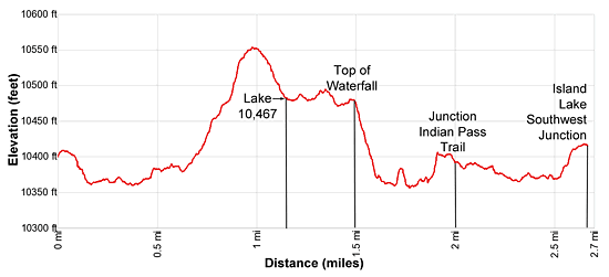
- Elevation: 10,410-ft. at Island Lake
10,560-ft. at Top of the Knoll
10,467-ft. at Lake 10467
10,450-ft. at Top of the Falls
10,365-ft. at Bottom of the Falls
10,410-ft. at Island Lake - Difficulty: moderate
- Basecamp: New Fork Lakes
- Region: Wyoming's Wind River Range
Island Lake Waterfall Hike Description
This is a great little hike to explore the Island Lake environs. The hike starts from at the unmarked junction at the southeast end of Island Lake (10,346-ft.). The trail to the left (northwest) leads to campsites along the lake’s southwestern shore. The path straight ahead (northeast) is the Indian Pass trail.
Follow the Indian Pass trail as it skirts the eastern shore of Island Lake. Along the way enjoy fine views of the summits towering above Titcomb Basin to the north. Elbow (11,948-ft.) and Sky Pilot (12,129-ft.) peaks rise in the distance to the northwest.
Pass an unmarked trail/route at 0.3 miles climbing to Pass 11,120, a saddle on the ridge between the Island and Wall Lake basins. Soon our trail curves to the left (north/northwest) around the northeast end of the lake and starts climbing.
At 0.7 miles the path curves to the right northeast and ascends the north side of a draw to a saddle on a low ridge at 0.9 miles. Atop the ridge are more great views of the summits of Titcomb Basin.
The trail now descends through meadows into the pretty basin cradling Lake 10,467. As you descend look for a use trail traveling along the lake’s southeastern shore. At 1.1 miles bear left on a spur trail that descends toward the lake shore and then turn left on the use trail skirting the lakes southeastern shore. Soon views open to a waterfall on the inlet stream on the north side of the lake. This is the stream draining Titcomb Basin.
Reach the south end of Lake 10,467 at 1.4 miles. Here a waterslide spills over polished slabs into a small unnamed lake. A brief descent leads to the lake shore. The trail now continues heading southwest, leaving the lake shore to circumvent rock outcroppings. Island Lake is now in view.
At 1.5 miles the trail reaches to top of a waterfall that plunges 60-feet down a rocky slope into the northeastern side of Island Lake. The trail now descends steeply through meadows along the east side of the falls to a viewpoint at the bottom of the beautiful cascade.
When you are done admiring the falls you have two options. Retrace your steps on continue along the loop, which involves some route finding. To continue the loop, follow a use trail that heads southeast along the lake shore. Views open to Mt. Lester (12,342-ft.) and a number of unnamed peaks rising above the eastern end of Island Lake.
Soon you will reach a low rocky knoll with steep cliffs blocking further travel along the shore. Here the trail climbs through willows and then brushy foliage to a saddle atop a knoll. The use trail fades and is difficult to follow as it travels through the thick foliage.
Atop the knoll you will see a cliff rising to the east. A talus field extends along the base of the cliff to the lakeshore. You have two options for completing the loop. From the saddle head due east, cross the rock pile and then descends to the lakeshore along the cliff on a trail of sorts. The other option is to descend from the saddle to the lakeshore through meadows to the west of the talus slope and then traverse the boulder field along the lakeshore to the edge of the cliff.
Where the cliff meets that lakeshore you will find a trail traveling through a willow thicket and then emerges on a meadow. After a short traverse through the meadow along the lakeshore the trail curves to the left (east) away from the lake and crosses a small drainage.
On the east side of the drainage the path fades as it climbs through willows. Ahead you will see the continuation of the trail climbing a low hill. Walk cross-country to the continuation of the trail and climb the hill. As you crest the hill the trail again fades but the way is now obvious. Descend through meadows, staying to the north of three small tarns, to the Indian Basin trail at 2.0 miles. Turn right (southeast on the trail) and retrace your steps back to southwest side of Island Lake.
Return to Segment 5: Indian Pass Trail to Island Lake
Go To Segment 6: Island Lake to Elkhart Park
Elevation Profile
Backpack Segments
- Introduction: New Fork Lakes to Island Lake & out Elkhart Park
- Segment 1: New Fork Trail: New Fork Lakes to New Fork Park/Palmer Lake Junction
- Segment 2: New Fork Trail: New Fork Park to Trail Creek Park via Lozier Lakes
- Segment 3: Highline Trail: Trail Creek Park to Elbow Lake Basin
- --- Side Trip: Peak Lake
- Segment 4: Highline Trail: Elbow Lake Basin to Indian Basin Trail
- --- Side Trip: Island Lake Backdoor
- Segment 5: Indian Pass Trail to Island Lake
- --- Side Trip: Titcomb Basin
- --- Side Trip: Indian Basin and Pass
- --- Side Trip: Island Lake Waterfall Hike
- Segment 6: Island Lake to Elkhart Park
Driving Directions to Elkhart Park Trailhead
New Fork Lakes Trailhead: Located on the northeast shore of Lower New Fork Lake, this trailhead offers an alternative and less crowded access point to the northwestern Wind River range without the long drive to Green River Lakes.
Directions from Pinedale: From the intersection of Pine Street (US 191) and North Tyler Ave (the Pinedale Tourism office is located on the northeast corner) in Pinedale, WY, drive west on Highway 191 (West Pine Street) for 6 miles and then turn right on WY-352 toward Cora. Follow WY-352 for 14.3 miles and turn right on County Road 162, a dirt road signed for New Fork Lakes. Follow the road for 4.8 miles to the end of the road. Along the way the road name will change to New Fork Lakes Road/Forest Service Road 732/730. The New Forks Lake parking area is on the left. The trailhead is located at the northeast corner of the lot.
The 25.2 mile trip should take about 40 minutes. Passenger cars can typically make it to the trailhead without any problems.
Elkhart Park Trailhead: From the intersection of Pine Street (US 191) and North Tyler Ave (the Pinedale Tourism office is located on the northeast corner) in Pinedale, WY, drive east on Highway 191 (East Pine Street) for 0.3 miles and bear left onto Fremont Lake Road. Follow this road for 14.3 miles and turn right into the large parking area for the Elkhart Park/Pole Creek Trailhead. After the first 3.0 miles the road will turn into Skyline Drive/Forest Service Road 370740. The trailhead is located at the northeast end of the parking lot between the outhouse and the trailhead kiosk. It should take about 25 minutes to drive the trailhead. The last section of the road has some holes and uneven spots.
Trail Resources
- Backpack Intro
- Segment Photo Gallery
- Segment Map
- Trailhead(s) Information: New Fork Lakes
- Region Information: Wyoming's Wind River Range
- Other Hiking Regions in: Wyoming