Details: Jade Lakes, Upper Brooks and Rainbow Lake 
Distance: 5.5 - 8.3 miles (round trip)
Shoshone National Forest, near Togwotee Pass in The Tetons
Hike Facts
- Distance: 5.5 - 8.3 miles (round trip)
- Elevation: 9,070-ft. - 9,596-ft.
- Elevation Gain: 555-ft. - 770-ft.
- Difficulty: easy-moderate
- Trail Highlights: See Trail Intro
- Basecamp(s): Togwotee Pass / Jackson Hole
- Region: The Tetons
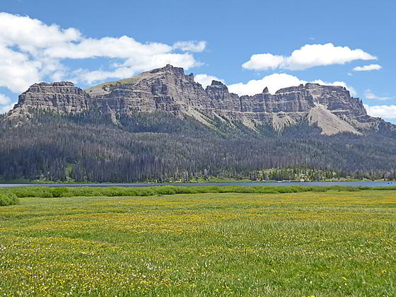
Multi-hued volcanic cliffs towering over 1,000-ft. above a quintet of pretty lakes are the stars of the show on these scenic hikes in the Brooks Lake area in the southern Absaroka Range, located to the east of the Tetons.
Jade Lakes Loop
Distance from Trailhead: 5.5 miles (loop)
Ending/Highest Elevation: 9,625-ft.
Elevation Gain: 555-ft.
Note: This hike is situated in the southern Absaroka Range near Togwotee Pass, located to the east of Grand Teton National Park. The hike is also easily accessible from Dubois, Wyoming.
The loop hike to the Jade Lakes starts at the southwest end of Brooks Lake, a 234-acre beauty, nestled beneath Pinnacle Buttes to the east and the volcanic cliffs rising along the Continental Divide to the west. (See driving directions below.) The hike initially follows the Yellowstone Trail as it travels through meadows awash in wildflowers along the west side of Brooks Lake. Along the way the path crosses four wood bridges spanning streams flowing into the lake.
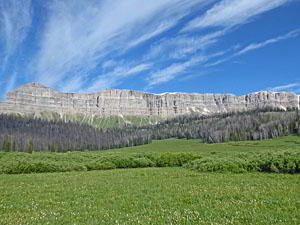
As you hike enjoy wonderful views of the multi-hued ridge of volcanic cliffs defining the Continental Divide to the west. Sublette Peak rises to the south of the ridge. The saddle between the two formations is Sublette Pass. Stunning Pinnacle Buttes, with colorful stratified volcanic layers eroded into fanciful pinnacles and spires, towers above Brooks Lake to the east.
Beyond the fourth creek crossing a single track trail breaks off to the right at 0.5 miles. Ignore this trail, which is a short-cut that crosses soggy meadows. Continue another tenth of a mile up the Yellowstone Trail to an unsigned junction. Here the braided Yellowstone Trail curves to the right and continues its journey up the west side of Brooks Lake toward Upper Brooks Lake. We bear left on the unsigned Upper Jade Lakes trail that ascends steeply through meadows. As you climb turnaround for views of the Brooks Lake Lodge and, in the distance to the southeast, the Wind River Range.
At 0.8 miles the trail reaches the top of a minor ridge, curves to the left and then ascends along the ridge crest, passing an unsigned trail branching right. At 1.0 mile the ascent ends and the trail soon reaches a second junction at a small clearing. Look carefully and you will see an old sign nailed to a tree pointing right to Jade Lakes. Turn right, ignoring the unsigned trails branching left.
After a brief descent the path resumes its ascent, skirting the edge of a lush meadow. Across the meadow to the east are fine views of the volcanic cliffs rising along the Continental Divide.
The trail soon plunges back into the trees. A short distance beyond the ascent ends and we now continue along the trail on easy grades.
At 1.4 miles the path curves to the right into a minor drainage, crosses a creek and then passes to the west of a small tarn. Beyond the tarn the trail curves to the left and resumes ascending through trees and meadows on moderate grades.
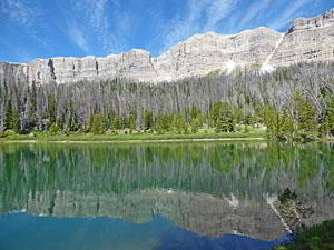
At 1.75 miles we reach the high point on the hike above the southeast end of Upper Jade Lake. Here we get our first views of the lake set against the backdrop of the cliffs towering above the divide to the west. A short descent leads to the wooded shore along the east side of Upper Jade Lake (9,532-ft.) at 1.8 miles.
The path now travels along the lake’s eastern shore, passing some nice viewpoints along the way. Pine bark beetles have killed over half the trees surrounding the lake. Despite the dead trees this is still a very scenic spot, with multi-hued volcanic cliffs soaring above the tree-lined lake.
At the northeast end of the lake the path crosses the outlet stream. Large logs lying in the creek bed facilitate the crossing. Past the crossing the path descends through trees to Lower Jade Lake, set in a forested bowl, at 2.4 miles. The trail now travels along the lower lake’s western shore. Unfortunately there are no views of the volcanic formations here. Still it is a pleasant lake.
Beyond the northwest end of the lake the trail turns west, descending through forest with the aid of some switchbacks to a junction with the Yellowstone Trail coming up from Brooks Lake at 3.25 miles. To complete the loop, turn right (southeast) and follow the Yellowstone Trail toward Brooks Lake.
The return journey travels on easy grades through the gorgeous meadows of the Brooks Creek Valley accompanied by terrific views of Pinnacle Buttes to the southeast, the volcanic cliffs rising to the north of the Bonneville Creek area and the cliffs soaring above the Continental Divide to the west. Behind you, at the head of the valley, the Bear Cub Plateau rises beyond Bear Cub Pass.
Along the way the path crosses two minor streams and then comes to a junction with the Upper Brooks Lake Loop Trail at 3.7 miles. (This undulating trail, starting at the junction, ascends through several muddy areas along the east side of the Brooks Creek Valley on its way to Upper Brooks Lake.) Continue descending down the valley on easy grades towards Brooks Lake. As you near the north end of the lake views open to the summits of the Wind River Range to the southeast.
At 4.4 miles, just before reaching the northwest end of Brooks Lake, the trail descends a short, moderately-steep hill and then levels, traveling along the west side of the lake to the junction with the trail to Upper Jade Lakes at 4.9 miles. Past the junction the path continues to the trailhead at the southwest end of Brooks Lake at 5.5 miles.
Brooks Lakes and Rainbow Lake
Distance from Trailhead: 7.4 miles (round trip)
Ending/Highest Elevation: 9,220-ft.
Elevation Gain: 186-ft.
Note: This hike is situated in the southern Absaroka Range near Togwotee Pass, located to the east of Grand Teton National Park. The hike is also easily accessible from Dubois, Wyoming.
This is the easiest hikes in the Brooks Lake area with only one short, moderately-steep climb. The rest of the trail travels on easy grades through scenic meadows up the Brooks Creek Valley to Upper Brooks Lake.
From Brooks Lake follow the Yellowstone Trail as it travels through beautiful meadows along the west side of Brooks Lake, crossing four wood bridges along the way. At 0.6 miles reach an unsigned junction with the Upper Jade Lakes branching left. Bear right on the continuation of the braided Yellowstone Trail.
As you hike enjoy wonderful views of the multi-hued ridge of volcanic cliffs defining the Continental Divide to the west. Sublette Peak rises to the south of the ridge. The saddle between the two formations is Sublette Pass. Stunning Pinnacle Buttes, with colorful stratified volcanic layers eroded into fanciful pinnacles and spires, towers above Brooks Lake to the east.
Reach the northwest end of Brooks Lake at 0.9 miles. The trail now climbs a short, moderately steep hill. At 1.1 miles the grade abates and distant views open southeast to the Wind River Range.
The path now ascends on easy grade through gorgeous meadows and clusters of willows up the Brooks Creek Valley, reaching a “Y” intersection at 1.8 miles. Here a sign to Upper Brooks Lake points left. This is the continuation of the Yellowstone Trail. To the right is an unsigned trail, sometimes referred to as the Loop Trail, which ascends the east side of the valley. (The Loop Trail to Upper Brooks Lake has muddy patches and more ups and downs than the Yellowstone Trail.)
Bear left on the Yellowstone trail. Beyond the junction the trail angles northwest, crossing two minor streams on its way to the junction with the Jade Lakes Trails. During the height of the summer this section of the trail is awash in wildflowers. The colorful display is accompanied by terrific views encompassing the volcanic cliffs of an unnamed butte rising to the north of the Bonneville Creek Valley (to the east), the volcanic cliffs along the Continental Divide to the west, Pinnacle Buttes to the southeast and the Bear Cub Plateau rising beyond the head of the valley to the north.
Past the second creek crossing the path turns to the left (west) and soon reaches an unsigned junction with the Upper Jade Lakes Trail ascending west through forest. We turn right, continuing the ascent up the Brooks Creek Valley on the Yellowstone Trail toward Upper Brooks Lake.
A short distance beyond the junction you will see a small Continental Divide Trail (CDT) marker nailed on a tree trunk. The Yellowstone and CDT trails now share the same path to Upper Brooks Lake and Bear Cub Pass. Along the way wood bridges span streams channeling snowmelt from the cliffs to the west. At times the trail ascends beside Brooks Creek, the stream meandering down the valley floor. Ahead are views of the Bear Cub Plateau rising beyond the head of the valley.
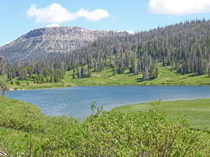
Reach the southwest end of Upper Brooks Lake (9,105-ft.) at 3.0 miles. This beautiful lake is set amid meadows near the head of the valley. The path now travels above the lake’s western shore to a creek crossing at 3.25 miles. This is the outlet stream for Rainbow Lake.
To visit Rainbow Lake cross the creek. On the north side of the creek turn left at an unsigned junction on the spur trail to Rainbow Lake. The path ascends on easy to moderate grades through meadows and then trees to pretty Rainbow Lake (9,220-ft.) at 3.7 miles. During the height of the summer the meadows along the trail are adorn with wildflowers. The peaceful, secluded lake lies nestled in forest. Views extend west across the lake to the volcanic cliffs rising to the west. When you are done enjoy the lake return to the junction at Upper Brooks Lake.
Beyond the Rainbow Lake outlet stream the Yellowstone Trail/CDT trail travels north above the west side of Upper Brooks Lake and then curves right (east) around the head (north end) of the lake to a junction. Here the Yellowstone Trail /CDT turn left (north) to Bear Cub Pass, a forested saddle. To the right is a trail, sometimes referred to as the Loop Trail, that heads down the east side of Upper Brooks Lake and the Brooks Creek Valley, eventually ending at the Yellowstone trail about one mile above the northern shore of Brooks Lake. (The Loop Trail travels through muddy patches and has more ups and downs than the Yellowstone Trail.)
When you are done enjoy the Upper Brooks Lake area, retrace your steps to the trailhead.
Jade Lakes, Upper Brooks Lake and Rainbow Lake Trail
Distance from Trailhead: 8.3 miles (round trip)
Ending/Highest Elevation: 9,625-ft.
Elevation Gain: 770-ft.
Note: This hike is situated in the southern Absaroka Range near Togwotee Pass, located to the east of Grand Teton National Park. The hike is also easily accessible from Dubois, Wyoming.
To combine the Jade Lakes Loop with the Upper Brooks Lake/Rainbow Lake hike, follow the Jade Lakes loop trail (above) to an unsigned junction with the Yellowstone Trail at 3.25 miles. At the junction, turn left (north) on the Yellowstone Trail that ascends on easy grades through meadows and willow thickets up the west side of the Brooks Creek Valley. The hike is accompanied by fine views of the colorful volcanic cliffs and buttes rising along the east side of the valley.
A short distance beyond the junction you will see a small Continental Divide Trail (CDT) marker nailed on a tree trunk. The Yellowstone and CDT trails share the same path to Upper Brooks Lake and Bear Cub Pass. Along the way wood bridges span streams channeling snowmelt from the cliffs to the west. At times the trail ascends beside Brooks Creek, the stream meandering down the valley floor. Ahead are views of the Bear Cub Plateau rising beyond the head of the valley.
Reach the southwest end of Upper Brooks Lake (9,105-ft.) at 3.9 miles. This beautiful lake is set amid meadows near the head of the valley. The path now travels above the western shore to a creek crossing at 4.15 miles. This is the outlet stream for Rainbow Lake.
To visit Rainbow Lake cross the creek. On the north side of the creek turn left at an unsigned junction on the spur trail to Rainbow Lake. The path ascends on easy to moderate grades through meadows and then trees to pretty Rainbow Lake (9,220-ft.) at 4.6 miles. During the height of the summer the meadows along the trail are adorn with wildflowers. The peaceful, secluded lake lies nestled in forest. Views extend west across the lake to the volcanic cliffs rising to the west. When you are done enjoy the lake return to the junction at Upper Brooks Lake.
Beyond the Rainbow Lake outlet stream the Yellowstone Trail/CDT travel north above the west side of Upper Brooks Lake and then curves right (east) around the head (north end) of the lake to a junction. Here the Yellowstone Trail /CDT turn left (north) to Bear Cub Pass, a forested saddle. To the right is a trail, sometimes referred to as the Loop Trail, that heads down the east side of Upper Brooks Lake and the Brooks Creek Valley, eventually ending at the Yellowstone trail about one mile above the northern shore of Brooks Lake. (The Loop Trail travels through muddy patches and has more ups and downs than the Yellowstone Trail.)
From Upper Brooks Lake the return leg of the hike follows the Yellowstone Trail back to the junction with the trail coming down from the Jade Lakes. Here we bear left, continuing down the Yellowstone trail, which briefly jogs east before turning southeast as it descend through the lovely meadows of the Brooks Creek Valley. Along the way the trail crosses two minor streams before reaching the junction with the Loop Trail at 6.5 miles. We continue descending on the Yellowstone trail on easy grades toward Brooks Lake.
At 7.2 miles, just before reaching the northwest end of Brooks Lake, the trail descends a short, moderately-steep hill and then travels along the west side of the lake to the junction with the trail to Upper Jade Lakes Trail at 7.7 miles. Past the junction the path continues to the trailhead at the southwest end of Brooks Lake at 8.3 miles.
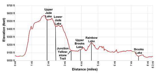
Elevation Profile
Driving Directions
From Dubois: From the corner of N 1st Street and US 26 in Dubois, drive 29.6 miles west/northwest on US 26/US287 to the signed turnoff for the Brooks Lake Recreation area on the right (north) side of the road. Turn right (north) and follow the Brooks Lake Road, a good dirt road, for 4.6 miles to an intersection. Bear left toward the campground and boat ramp for Brook Lake. A sharp left leads to the Brooks Lake Lodge while straight ahead is the continuation of the Brooks Lake Road. Drive 0.2 miles to a loop road servicing the boat dock. The trailhead and a parking lot are located along the left side of the loop road.
From Jackson: From the corner of W. Broadway and Cache Streets, at the southwest corner of the Jackson Town Square, head north on N Cache Street (US 191 N/US 89 N/ US 26 E) for 30.1 miles to Moran Junction. Here US 191/US 89 turn left toward the Jackson Lake area of Grand Teton National Park and Yellowstone. We bear right (east) on the continuation of US 26 E/ US 287 toward Dubois. Drive 25.8 miles east to the signed turnoff for the Brooks Lake Recreation area on the left (north) side of the road. (You will cross Togwotee Pass at 25.3 miles.)
Turn left (north) and follow the Brooks Lake Road, a good dirt road, for 4.6 miles to an intersection. Bear left toward the campground and boat ramp for Brook Lake. A sharp left leads to the Brooks Lake Lodge while straight ahead is the continuation of the Brooks Lake Road. Drive 0.2 miles to a loop road servicing the boat dock. The trailhead and a trailhead parking lot are located along the left side of the loop road.
Trail Resources
Trail Intro / Trail Photo Gallery / Trail Map
Basecamp(s) Information:
Togwotee Pass / Jackson Hole
Region Information:
The Tetons
Other Hiking Regions in:
Wyoming