Slickrock 
Distance: 2.6 miles
Needles District, Canyonlands National Park, near Canyonlands in Southeast Utah
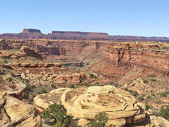
Vista from viewpoint 3
This interesting trail loops around the slickrock-topped mesa between Big Spring and Little Spring Canyons, offering good views of two canyons and surrounding landmarks. The trail is a great option for families or anyone who has never hiked on slickrock.
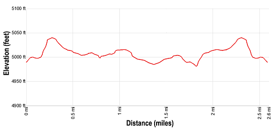
- Distance: 2.6 miles (Loop)
- Elevation: 4,960-ft. at Trailhead
Maximum elevation - 5,040-ft. - Elevation Gain: 80-ft.
- Difficulty: easy-moderate
- Basecamp: Canyonlands / Monticello
- Region: Southeast Utah
Trail Description - Slickrock
Note: The mileage for this hike includes the spur trails to the overlooks.
The Slickrock trail visits four viewpoints with scenic vistas of the surrounding landmarks in Needles District of Canyonlands National Park and beyond. Additional viewpoints will be discovered as the trail winds around the head of the slickrock-top mesa between Big Spring and Little Springs Canyon.
The trail, marked with cairns (small rock piles), starts on the right (east) side of Highway 211 (see driving directions below) and heads northeast ascending on easy grades through scattered pinyon pines and junipers. At 0.25 miles the path curves to the left (north) and soon comes to a sign pointing right (east) toward the first viewpoint at 0.3 miles. As short spur trail leads to an overlook with nice, albeit distant views of Cathedral Butte, Six Shooter Peak, the Needles to the southwest, the La Sal Mountains to the northeast and the Abajo Mountains to the southeast.
Back on the main trail arrive at a “Y” intersection and the beginning of the loop trail at 0.5 miles. Hike the trail in a counter-clockwise direction by taking the trail to the right. A short distance past the intersection is a sign pointing right (east) toward the second viewpoint. A spur trail quickly leads to the viewpoint overlooking the upper end of Little Spring Canyon.
Return to the main trail, which now continues north along the rim of Little Spring Canyon. Island in the Sky dominates the view to the north while the La Sal Mountains, typically snow-capped until early summer, standout against the landscape to the northeast.
Find the third viewpoint at 1.0 mile. Here we enjoy great views of Island in the Sky and Junction Butte to the north. Nearer at hand are the lower reaches of Little Spring Canyon. In the distance to the southwest are the Needles, spires of red and white Cedar Mesa Sandstone.
Beyond the third viewpoint the trail curves to the left (northwest) and gets a bit rockier, but should not cause any difficulties. At 1.1 miles reach a trail junction with a sign pointing right (north) to the fourth overlook. This half mile detour off the main loop is well worth the time and effort.
The spur trail to the fourth viewpoint descends slickrock benches to a overlook above Big Spring Canyon. This rugged canyon is framed by views to the north of Island in the Sky and Junction Butte. Find a nice peach along the cliffs to take a break and enjoy the views.
When you are done soaking in the views return along the spur trail to the junction and then follow the loop trail south along the west side of the mesa. As you walk fine views open to the Needles to the southwest.
The path reaches the end of the loop at 2.1 miles. From here retrace your steps to the parking area for a 2.6 mile hike.
Elevation Profile
Driving Directions
From Moab: Drive south on U.S. Highway 191 for roughly 40 miles to Utah Highway 211 (signed for Canyonlands National Park, Needles District) and turn right (west). Follow Utah Highway 211 west for 40 miles. Near the end of the road find the Slickrock trailhead parking area on the right. More parking is located at the end of the road.
From Monticello: Drive north on U.S. Highway 191 for roughly 14.3 miles to Utah Highway 211 (signed for Canyonlands National Park, Needles District) and turn left (west). Follow Utah Highway 211 west for 40 miles. Near the end of the road find the Slickrock trailhead parking area on the right. More parking is located at the end of the road.
From Blanding: Drive north on U.S. Highway 191 for roughly 34.8 miles to Utah Highway 211 (signed for Canyonlands National Park, Needles District) and turn left (west). Follow Utah Highway 211 west for 40 miles. Near the end of the road find the Slickrock trailhead parking area on the right. More parking is located at the end of the road.
Trail Resources
- Trail Photo Gallery
- Trail Maps
- Basecamp(s) Information: Canyonlands / Monticello
- Region Information: Southeast Utah
- Other Hiking Regions in: Utah