Fremont Petroglyphs 
Distance: 0.3 miles
Fruita District, Capitol Reef National Park, near Capitol Reef in South Central Utah
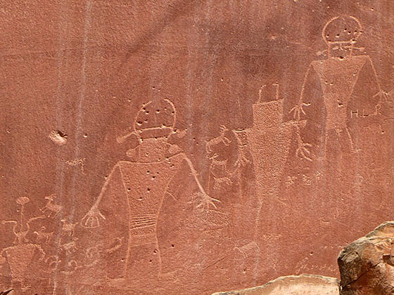
Main Rock Art Panel
Short, easy walk along two boardwalks lead to interesting petroglyph panels carved into Wingate sandstone cliffs along the north side of the Fremont River valley.
- Distance: 0.3 miles (RT)
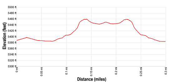
- Elevation: 5,380-ft. at Trailhead
Maximum elevation - 5,460-ft. - Elevation Gain: 80-ft.
- Difficulty: easy
- Basecamp: Capitol Reef
- Region: South Central Utah
Trail Description - Fremont Petroglyphs
Archeologists have found evidence of native people of the Fremont Culture living in the Capitol Reef area between 600 and 1300 C.E. They lived in pit houses (dug into the ground and covered with a brush roofs) and natural rock shelters. While primarily hunter-gatherers, they supplemented their diet by farming, growing corn, beans and squash along the river bottoms. Edible native plants included pinyon nuts, rice grass and a variety of berries, nuts, bulbs, and tubers. Corn was ground into meal on a stone surface (metate) using a hand-held grinding stone (mano). Deer, bighorn sheep, rabbits, birds, fish and rodents were hunted using snares, nets, fishhooks, the Atlatl (spear-throwing stick) and the bow and arrow.
The Fremont left records of their life in the area in the form of pictographs (painted on rock surfaces) and petroglyphs (carved or pecked into the rock surface) on the Wingate sandstone cliffs and rocks. Images typically depict anthropomorphs (human-like figures) and zoomorphic (animal-like) figures including bighorn sheep, deer, dogs, birds, snakes and lizards. Abstract designs, geometric shapes and handprints are also common. Designs may have recorded religious or mythological events, migrations, hunting trips, resource locations, travel routes, celestial information and other important knowledge.
The petroglyph panels along this area of the Fremont River are accessible via short, easy walks along two boardwalks. The site is quite pleasant, shaded by cottonwood trees.
The main panel, found at the end of the western boardwalk, is a well preserved panel with anthropomorphic (human-like) figures that have trapezoidal shaped bodies with arms, legs and fingers. The figures are adorned with headdresses, ear bobs, necklaces and clothing items. The panel also includes bighorn sheep, deer, a rabbit and other animals.
The second boardwalk, to the east, skirts the base of the Wingate cliffs. The petroglyphs along this section of the wall are fainter and harder to see. Some of the human-like figures wear clothing with geometric patterns and have well defined hands. Other images look like necklaces, stars or animals, such as deer and sheep.
The boardwalks are wheelchair accessible. The park service provides binoculars at the main panel to facilitate viewing the rock art. A zoom lens on your camera is needed to get good photos.
Elevation Profile
Driving Directions
Capitol Reef Visitor Center: Turn left out of the Visitor Center on Campground Road and after 100-ft. turn right onto UT 24 East. Drive 1.1 miles and turn left into the Fremont Petroglyph parking lot. There are two boardwalks. The first boardwalk is located on the north side of the parking and the second at the eastern end of the parking area.
Trail Resources
- Trail Photo Gallery
- Trail Maps
- Basecamp(s) Information: Capitol Reef
- Region Information: South Central Utah
- Other Hiking Regions in: Utah