Apache Canyons colorful walls
This trail ascends to and then travels across Burro Mesa to an old corral, part of the Sam Nail Ranch. Hikers must then plot their own course to the ruins of an old cabin and the head of Apache Canyon for great views colorful rock formations composed of chert (flint).
- Distance: 7.2 - 8.8 miles (RT)
- Elevation: 3,765-ft. at Trailhead
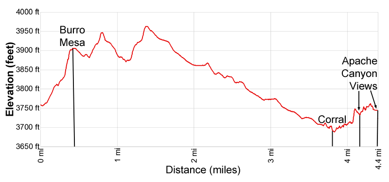
Maximum elevation - 3,965-ft. - Elevation Gain: 200-ft.
- Difficulty: moderate-strenuous
- Basecamp: Big Bend
- Region: Texas Parks
Trail Description - Apache Canyon
Note: There are a lot of ups and downs on this hike making the elevation gain/loss about 900-ft.
This trail is recommended for experienced hikers. A map of the area is extremely helpful. The established trail is unsigned and not listed on any park service brochures since it leads to historic ruins and quarries used by Native Americans. Follow “Leave No Trace” practices when visiting these sites and do not take anything you find.
The establish trail ends at a stone corral that was part of the Sam Nail Ranch. Reaching Apache Canyon required off trail hiking and route finding skills. The entire trail is exposed to the sun and can be very hot. Take plenty of water. It is best to get an early start and hike this trail in the cooler months.
From the pullout along the east side of the Ross Maxwell drive, 4.6 miles from the north end of the road (see driving directions below), cross to the west side of the road to the point where the creek crosses the road. Head southwest up the creek’s sandy wash for 200-ft. Look right to see a rock cairn marking a trail on the bank above the wash. This is the Apache Canyon trail.
Follow the path as it heads west/northwest, ascending on easy to moderate grades through desert scrub scattered with cacti. Turn around for great views of the Chisos Mountains towering above the desert floor to the east.
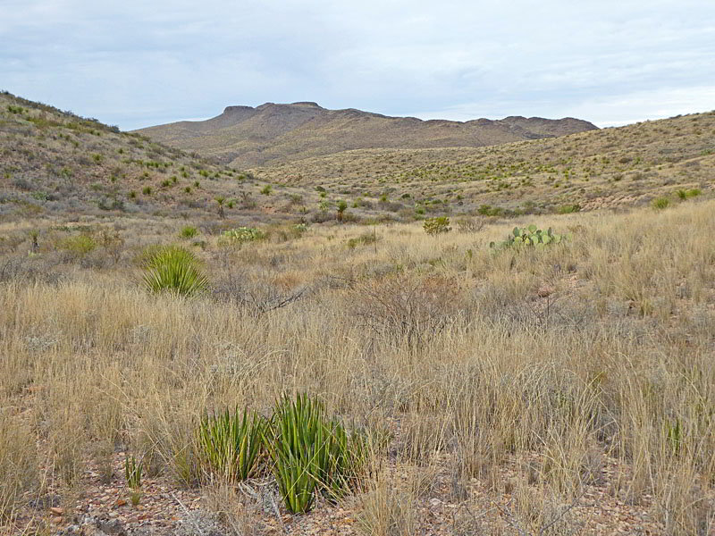
At 0.35 mile the trail crests the top of Burro Mesa. Here an old sign, the site of a former trail register, is no longer readable. Ahead are views of sparsely vegetated hills and drainages atop the mesa.
The undulating path now descends on moderate grades through grasses and scrub growth, crossing two washes before ascending to a ridge at 0.8 miles. From the ridge the trail again descends along the north side of a wash, crossing minor tributaries along the way. At 1.1 miles the path briefly drops into the wash and follows it a short distance downstream. Watch for rock cairn marking where the path exits the wash.
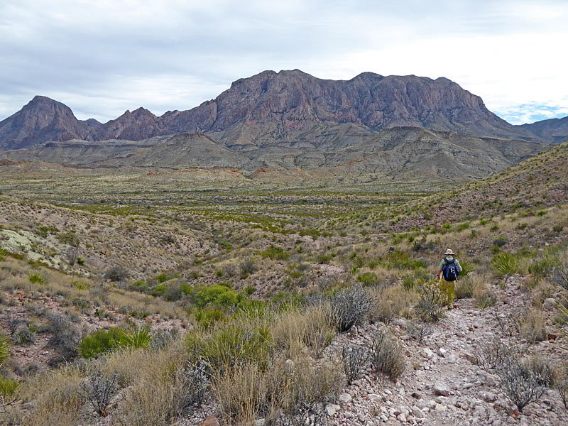
Beyond the wash the trail climbs on moderate grades to a ridge crest at 1.3 miles. Atop the ridge enjoy more fine views of the Chisos Mountains to the east. The path now descends on gentle grades, crossing a few washes along the way. Ahead views open to two rounded peaks rising to the west, Peak 4145 and Peak 4085. At the base of Peak 4145 (the western peak) is the first destination of our hike, a corral used by the Sam Nail ranch.
At 2.0 miles a brief ascent leads to the crest of a minor ridge at 2.1 miles. From the ridge crest an undulating path descends along the south side of a valley. Near the foot of the valley, at 2.9 miles, the trail crosses the wash to the north side of the valley where is curves to the right (north/northwest), climbs over a low ridge and then drops into a broad valley. Ahead the valley narrows where it passes between the two rounded peaks, Peak 4145 on the west side of the valley and Peak 4085 on the east side of the valley.
Follow a boot beaten path descending on gentle grades down the east side of the valley. At 3.3 miles the path curves to the left and crosses the wash to the west side of the valley. The trail now heads toward the base of Peak 4145.
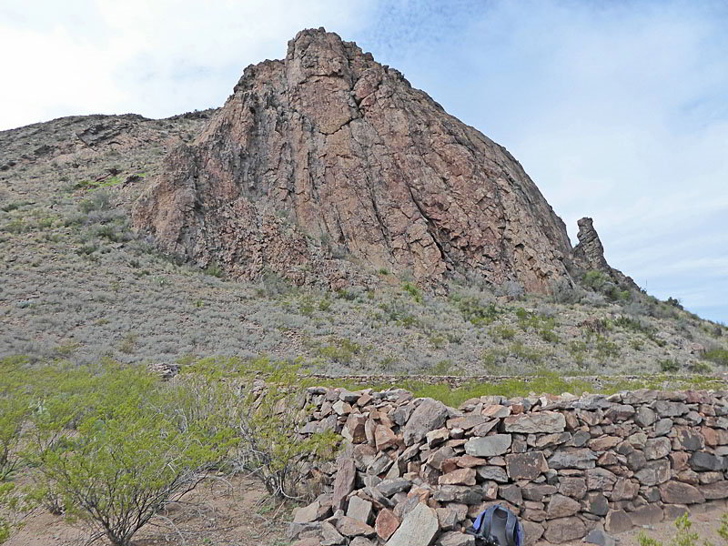
Reach the Nail’s large, well preserved stone corral at the base of the Peak 4145 at 3.6 miles. The corral, measuring 150-ft. by 90-ft., is composed of 4- to 5-foot high walls that are 2- to 3-feet thick. Across the valley (east) are fine views of Peak 4085.
The corral marks the end of the established trail. If you are comfortable with off trail exploration there are two additional destinations in the area. If not, take a break at the corral and then retrace your steps to the trailhead for 7.2 mile hike.
To continue exploring, walk along the east wall of the corral. At the north end of the corral hike northwest, paralleling the base of the Peak 4145, to the wash. Cross the wash and then head north, climbing the hill rising above the wash. At 3.7 miles reach the ruins of a stone cabin. A few of the thick walls still remain. The cabin features nice views of Peak 4145 and Peak 4085 along with the corral.
The cabin and corral are located at the confluence of two valleys. The valley we descended to reach the corral continues downstream (northwest/west), curving around the north facing slopes of Peak 4145. A second valley extends northeast, with the east side of the valley rimmed by the northwest facing flanks of Peak 4085.
Our next goal is an overlook above Apache Canyon. To reach Apache Canyon we must travel up the northeast valley. Initially the easiest route follows the wash upstream. So from the cabin descend northeast into the wash.
At 3.9 miles the wash becomes choked with vegetation. When this occurs climb left (west) out of the wash and ascend the slopes along the west side of the valley. It is best to climb about 40-60 feet above the valley floor. Here the vegetation is sparser and the angle of the slope is reasonable for walking. You will probably need to adjust your course to avoid gullies.
After 0.3 miles you will notice the ridge above you is not as high. At this point curve to your left and head for a saddle on the ridge. Reach the ridge crest at 4.25 miles. You should now be standing atop a saddle above the upper end of colorful Apache Canyon.
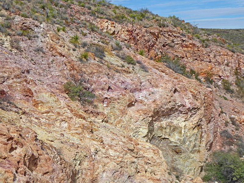
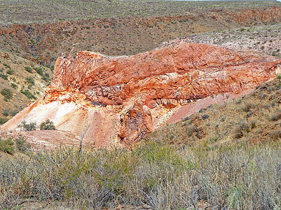
The canyon is located along Burro Mesa’s western slopes. The rock walls along the upper end of Apache Canyon are composed of chert (aka flint) a silica rich, crystalline material that fractures into pieces with very sharp edges. Native Americans used chert to make arrowheads and a variety of implements.
The chert walls on view from the saddle are in lovely shades of mauve, pink, orange and white. Further down the canyon are bright orange and white walls. After viewing the first area continue along the ridge to a second overlook at 4.4 miles. The walk is accompanied by distance views of the Chisos Mountains to the east and views of one of the amazing orange walls. The second overlook offers additional views of the canyon’s multi-colored walls along with the Christmas Mountains, rise in the distance to the north.
When you are done enjoying the views, retrace your route to the corral and then follow the trail back to your vehicle for an 8.8 mile round-trip hike.
Elevation Profile
Driving Directions
From the Big Bend National Park Headquarters at Panther Junction: From Panther Junction, at the intersection of the Persimmon Gap Road and the West Entrance Road, head west on the West Entrance (Gano Springs) road toward Basin Junction. Follow the road for 12.7 miles and then turn left on the Ross Maxwell Scenic Drive. Drive 3.3 miles on the Ross Maxwell road to the Sam Nail Ranch. Now you need to start paying attention.
The hike starts 1.3 miles south of the Sam Nail Ranch trailhead. Head south on the Ross Maxwell Scenic Drive, an asphalt road, for 0.3 miles to dip in the road, a flood-resistant concrete low water crossing, where Cottonwood creek crosses the highway. Continue heading south for another mile to a second concrete low water crossing and park along the wide pullout on the east (left) side of the road. (Total distance 4.6 miles from the north end of the Ross Maxwell Drive.)
Start the hike by carefully crossing to the west side of the road to the point where the creek crosses the road. Head up the creek’s sandy wash for 200-ft. Look right to see a rock cairn marking a trail on the bank above the wash. This is the Apache Canyon trail.
From the Chisos Mountain Lodge area: Head northeast on Chisos Basin Road for 6.4 miles and then turn left onto the West Entrance Road. Follow the West Entrance Road for 9.5 miles and the turn left onto the Ross Maxwell Scenic Drive. Drive 3.3 miles on the Ross Maxwell road to the Sam Nail Ranch. Now you need to start paying attention.
The hike starts 1.3 miles south of the Sam Nail Ranch trailhead. Head south on the Ross Maxwell Scenic Drive, an asphalt road, for 0.3 miles to dip in the road, a flood-resistant concrete low water crossing, where Cottonwood creek crosses the highway. Continue heading south for another mile to a second concrete low water crossing and park along the wide pullout on the east (left) side of the road. (Total distance 4.6 miles from the north end of the Ross Maxwell Drive.)
Start the hike by carefully crossing to the west side of the road to the point where the creek crosses the road. Head up the creek’s sandy wash for 200-ft. Look right to see a rock cairn marking a trail on the bank above the wash. This is the Apache Canyon trail.
Trail Resources
- Trail Photo Gallery
- Trail Maps
- Basecamp(s) Information: Big Bend
- Region Information: Texas Parks
- Other Hiking Regions in: Texas