Hike Facts
- Distance: 10.9 miles (one way)
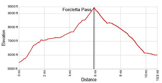
- Elevation: 5,488-ft. - 9,424-ft.
- Elevation Gain: 3,936-ft.
- Difficulty: strenuous
- Trail Highlights: See Trail Intro
- Basecamp(s): Zinal / Gruben
- Region: The Valais
This scenic route between the Val d'Anniviers and Gruben crosses Forcletta Pass and features panoramic views of the high peaks towering above the head of the Zinal and Turtmann Valleys.
Zinal to Forcletta Pass

Distance from Trailhead: 5.9 miles (one way)
Ending/Highest Elevation: 9,424-ft.
Elevation Gain: 3,936-ft.
Note: Trail mileage for this hike assumes you start near the Pam Supermarket on the main street in Zinal. The Pam is a short distance to the south of the bus station. (See trailhead directions below.)
From the Pam Supermarket, cross the main street and take the steps leading up to the Poste Hotel. At the top of the stairs turn right (south) on a paved street. Walk up the street past the Thrift Hotel and then turn left (east) on the next street. Follow this street as it passes a church (on your right) and a large hotel complex (on your left).
At the east end of the hotel take the path branching to the left (northeast) through the grass. The path climbs to meet a road near an intersection. Cross the street and head up the road directly in front of you. There is a sign post along the left side of the road near a group of garages pointing straight ahead (northeast) toward Lirec, Barneuza Alpage and Hotel Weisshorn. (On the first segment of the hike follow signs pointing toward Lirec and the Hotel Weisshorn.)
The road ascends between the Les Erables and Les Arellaz apartment buildings. Behind the Erables the road curves to the left and turns into a seldom used dirt road.
Follow the dirt road as is climbs steeply uphill. At 0.4 miles pass through a large culvert, providing a route under a large earthen dike, that is part of the town’s avalanche and flood control system. Continue along the road as it crosses a stream and passes a chalet.
At 0.5 miles reach a “Y” intersection. The trail to the right leads to Arolec. We bear left, heading north/northeast, on the road toward Lirec, Barneusa (Barneuza) and Hotel Weisshorn.
Cross a small stream and then ascend steep switchbacks up a forested hillside. As you climb watch for places where trails shortcut long hairpin curves in the road. Signs or red and white blazes will mark the shortcuts.
Soon the road breaks out of the trees and climbs steeply through open meadows. Take occasional breaks from the climb to enjoy the views behind you (to the south) of Besso, Pointe de Zinal, Dent Blanche and Grand Cornier towering above Val de Zinal (Zinal Valley).
Just below Lirec, a small chalet perched high above the valley, leave the road for good by taking the trail branching right that heads straight up hill through meadows toward the chalet.
Reach Lirec at 1.1 miles. The trail skirts the right (east) side of the chalet, climbs a hill and then passes through a gate. Signs along the way point toward the Hotel Weisshorn.
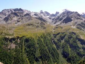
Beyond the gate the trail ascends on moderate grades through a larch and pine forest along the valley’s east wall. To your left (west), the hillside drops steeply to the Zinal Valley. Segments of the trail with some exposure are fenced or lined with ropes for added safety. The trail should not present any problems unless it is icy. Breaks in the trees offer nice views of the Garde de Bordon on the west side of the valley.
At 1.7 miles, about an hour from Zinal, the grade abates at a small meadow. Ignore the trail branching right toward Promenade des Arolles. We continue straight ahead (north) toward Barneuza Alpage and the Hotel Weisshorn.
The trail now traverses a narrow shelf on easy grades with nice views of the Garde de Bordon and the Corne de Sorebois across the valley. Behind you are magnificent views of the high peaks forming the glacial cirque at the head of the Zinal Valley.
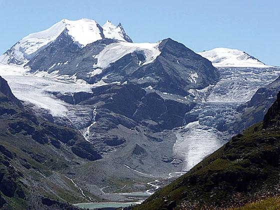
Pass two cement structures (on your right) housing hydro equipment and then curve around the foot of the Barneuza Valley to Barneuza Alpage (7,254-ft.), a small alp at 3.0 miles. From this vantage point the tip of Matterhorn is seen peeking above the cirque at the head of the Zinal Valley.
Signs at the alp point left to a path dropping to Ayer and Mottec on the valley floor. We bear right on the trail toward Belle Le (50-min) and Hotel Weisshorn (1-rh 40-min), which ascends on moderate grades through pretty meadows and small boulder fields as it curves around the end of a ridge.
At 3.6 miles the trail curves to the right and enters a side valley. A small grassy knoll just before the turn is a good place for a quick break to take in the stunning views of the Zinal Valley.
Follow the trail as it ascends on moderate grades heading east along the southern slopes of the side valley. Behind you, to the west, views open to Grimentz and the peaks towering above the resort at the foot of the Val de Moiry. Soon the trail crosses a stream and curves to the left (north/northwest) above an old building, reaching a trail junction (7,677-ft.) at 4.3 miles. Here we leave the trail bound for the Hotel Weisshorn and turn right (east) toward Forcletta (1-hr 45-min) and Gruben (4-hr 30-min).
The narrow trail ascends steeply through lush and sometimes boggy pastures. Keep an eye out for red and white blazed rocks to keep you on track. Soon the path becomes easier to follow as it curves around the south side of a large bowl before the final steep climb to alp Tsahelet (8,278-ft.) at 4.7 miles.
As you approach the alp the trail fades. To keep on track head for the milking barn, staying to the left of the large cross atop a rock outcropping. A sign behind the cross points toward Forclettaz (Forcletta Pass).
Turn right when you reach the alp road and walk to the end of the barn. Here a trail skirts the south side of the barn and then takes a sharp left, climbing steeply up the hill behind the barn. Signs along the path point toward the pass. A few large flat rocks along the trail offer nice spots to take a break and enjoy the views of the peaks towering above Grimentz.
Soon the path tops a rise and briefly travels through rolling pastures to a small tarn at the base of a steep hill at 5.2 miles. As you cross the pasture note the saddle (low point) on the ridge at the top of the hill, this is the pass.
Just beyond the tarn is a trail junction. The path to the left (northwest) heads toward the Hotel Weisshorn and St. Luc. The trail branching to the right climbs steeply through rocky meadows and small rock slides on switchbacks to Forcletta Pass (9,430-ft.), the boundary between the French-speaking Valais and the German-speaking Wallis, at 5.9 miles. Here signs point east toward Meidan-Gruben (2-hr 20-min).
From the pass views extend north to the Bernese Alps. Nearer at hand the Pointe de la Forcletta rises along the rugged ridge to the north of the pass. The Corne de Sorebois and the peaks towering above the Val d'Anniviers fill the horizon to the west. The top of Dent Blanche and Grand Cornier poke above a dark ridge to the south. Dominating the skyline to the east is a wall of summits rising above the Turtmanntal (Turtmann Valley). Unfortunately views of the peaks at the head of the valley are blocked by a ridge. Great views of these peaks will gradually unfold as you descend from the pass toward Gruben.
Forcletta Pass to Gruben
Distance from Trailhead: 10.9 miles (one way)
Ending/Highest Elevation: 5,988-ft.
Elevation Gain: -3,436-ft.
To continue to Gruben, follow the trail as it drops steeply down the east side of the pass, traversing scree covered slopes along the left (north) side of the Bluomattalli valley. Along the way, cross two small streams draining the slopes to the north of the trail.
At 6.8 miles the trail curves to the northeast as it heads around the end of a ridge. The grade abates as the trail travels through beautiful rolling alpine meadows sprinkled with wildflowers. A small peak, Le Boudri, rises to the west. With each step enjoy every-improving views of the peaks towering above the head of the Turtmanntal.
After a brief uphill stint the trail traverses above and then drops down to Chalte Berg (8,000-ft.) at 7.4 miles. Here a muddy trail, heading toward Gruben (1-hr 30-min), descends between the Alp buildings. The trail is not always easy to follow. When you reach a dirt road on the east side of the alp there are two ways to continue. The easiest is to follow the farm road down.
Alternatively look to your left (east) and downhill. You should see a faint, boot-beaten path through the grass. This trail descends steeply through pasture to join the farm road. There are a few red and white blazed rocks along the way. When you reach the farm road, turn left (north) on the road.
Whichever way you go, find a nice spot to stop and enjoy the spectacular views of the Brunegghorn, Bishorn and Tete de Milon that form the massive glacial cirque at the head of the valley. The top of the Weisshorn towers above the cirque. The Turtmann and Brunegg glaciers, along with several waterfalls, spill down the flanks of the peaks. A man-made lake catches the meltwater near the edge of a hanging valley.
Travel along the road for a short distance, if you descended on the trail from the alp, or follow the farm road for 0.6 miles from the alp. Soon you will see a sign to the right (east), slightly below the road, point toward Gruben. Drop down to the trail and turn left (north) toward Gruben.
Travel along the trail as it parallels the road for about 0.3 miles. It is a pretty walk through meadows sprinkled with flowers and low-lying shrubs. In the distance to the north are views of the Bernese Alps. Gruben is now visible on the valley floor.
At 8.5 miles the trail curves to the right (east) and descends through pastures, shortcutting long switchbacks on the road. Soon the trail rejoins the road and follows it around two hairpin curves. Beyond the second hairpin turn watch for a rock on the right (west) side of the road with a red/white arrow pointing downhill. Past the rock look for a post on the left side of the road at 8.8 miles that marks a trail branching to the left. Turn left (east/southeast) on the trail.
Follow the trail as it descends through meadows and then forested hillsides on moderately-steep switchbacks. At 9.8 miles the trail passes along the right (south) side of a group of buildings to a road. Look up valley for a different perspective of the peaks and glaciers towering above the head of the valley.
At the road signs points right (southwest) toward Stausee and the Turtmann Hut. We turn left (northeast) on the road toward Gruben. Follow the macadam road for a short distance along the left (west) side of the river. Just before the road crosses the river you will see trail signs on your left. Take the trail branching left (north) from the road toward Gruben. Do not cross the bridge over the river.
The trail parallels a wooden fence for a short distance, crosses a stream and then travels through meadows on easy grades, passing a small hamlet on the left. Along the way views open to the Schwarzhorn looming over the small village of Gruben. The historic Hotel Schwarzhorn, a stone building with red shutters, is easy to spot
Pass to the right (east) of a house and reach trail signs at 10.5 miles. Bear right (northeast) on the trail toward Gruben, which crosses the river on a good bridge. When you reach the road on the other side of the river turn left (north). You are now in Gruben (5,988-ft.). Walk a short distance north along the road to the Hotel Schwarzhorn at 10.8 miles.
Note there is no places to purchase food or drink along the trail. Pack a lunch and take plenty of water. Get an early start for the best views. Clouds often obscure the high peaks in the afternoon.
The Hotel Schwarzhorn is a busy little place with a nice restaurant and large backyard for relaxing with a cold beer after a long hike. If is best to have advanced reservations if you plan to spend the night here.
Elevation Profile
Driving Directions
Directions to the trailhead from Zinal: From the Pam Supermarket on the main street in Zinal (just south of the bus station), cross the street and take the steps leading up to the Poste Hotel. At the top of the stairs turn right (south), walk up the street past the Thrift Hotel and then turn left (east) on the next street. Follow this street as it passes a church (on your right) and a large hotel complex (on your left).
At the east end of the hotel take the path branching to the left (northeast) through the grass. The track climbs to meet a road near an intersection. Cross the street and head up the road directly in front of you. There is a sign post along the left side of the road pointing straight ahead (northeast) toward Lirec, Barneuza Alpage and Hotel Weisshorn. Walk in the direction indicated by the sign.
The road ascends between two large apartment complexes, Les Erables and Les Arellaz. Follow the road as it curves to the left behind Les Erables to meet a dirt road ascending the hill. This is the way to the Hotel Weisshorn and Forcletta Pass. (On the first part of this walk, follow the signs pointing toward Lirec, Barneuza Alpage and Hotel Weisshorn.)
Direction to the trailhead from Gruben if walking the route in reverse: From the Hotel Schwarzhorn, walk south along the road for 0.2 miles to a “Y” intersection and take the minor road branching right (southwest), which crosses a bridge over the river. From here follow the directions above in reverse, always looking for signs directing you toward Forcletta Pass and Zinal. (On the west side of the pass you will see large yellow “Z’s” painted on rocks directing you toward Zinal.)
Trail Resources
Trail Intro / Trail Photo Gallery / Trail Map
Basecamp(s) Information:
Zinal / Gruben
Region Information:
The Valais
Other Hiking Regions in:
Switzerland