Col Torrent: Les Hauderes to Cabane de Moiry 
Distance: 9.5 miles (one way)
Valais, near Les Hauderes in The Valais
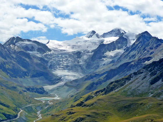
Moiry Glacier, Grand Cornier and Dent Blanche
A strenuous day hiking over the Col de Torrent followed by a climb to the Cabane de Moiry features amazing views of the glacier-clad summits towering above the Val d’Herens, the Val d’Arolla and the Val de Moiry. The challenging climb to the hut features breathtaking view of the Moiry Glacier.
See Trail Detail/Full Description
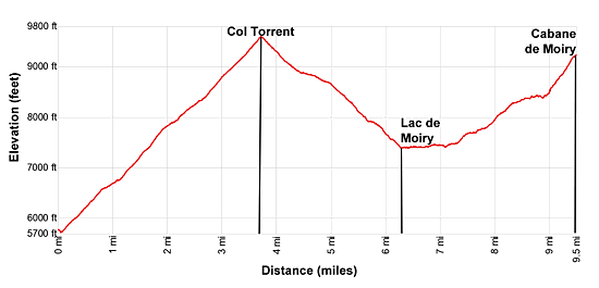
- Distance: 3.7 miles (one way) to Col Torrent
9.5 miles (one way) to Cabane de Moiry - Elevation: 5,716-ft. at Trailhead
9,576-ft. at Col Torrent
9,268-ft. at Cabane de Moiry - Elevation Gain: 3,860-ft. to Col Torrent
5,726-ft. to Cabane de Moiry - Difficulty: strenuous
- More Hikes in:
Les Hauderes / The Valais
Why Hike Col Torrent: Les Hauderes to Cabane de Moiry
The hike over the Col de Torrent to the Cabane de Moiry is considered one of the most scenic legs on the Walker’s Haute route and also one of the most strenuous. Hikers are well compensated for their efforts with grand views of three magnificent glacial valleys, panoramic vistas from the Col de Torrent and dramatic, up-close views of the Moiry Glacier.
I strongly recommend starting the hike by taking the bus from Les Hauderes to La Sage Villaz, which saves time and eliminates a 900-ft. climb. From La Sage the trail ascends through beautiful meadows and then scree covered slopes along the east side of the Val d’Herens to the Col de Torrent. Breathtaking views accompanying the hike extend to the head of the Val d’Herens where a cirque of the 11,000 to 14,000-ft. peaks soar above a massive ice sheet spilling down the valley that separates into two separate flows, the Glacier de Ferpecle and Glacier du Mont Mine. To the north Diablerets rises above the Rhone Valley.
As you gain elevation views expand, stretching southwest to the summits, clad in glistening glaciers, towering over the Arolla Valley. On a clear day vistas extend beyond Arolla to Mont Blanc de Cheilon and the Grand Combin.
As you crest the pass views open east to the Weisshorn towering above the ridge rimming the eastern wall of the Moiry Valley. From the pass the trails drops steeply from the ridge and then passes the lovely Lac des Autannes, with wonderful views of Dent Blanche, the Grand Cornier and the Glacier de Moiry flowing down the flanks of the peaks encircling the head of the Val de Moiry.
Above the alp at Montagne de Torrent (Alpage de Torrent) our path splits from the main route dropping down to the dam at the foot of the Lac de Moiry. Here we bear right on a trail descending southeast that soon joins the trail along the lake shore leading to the head of the lake. Along the way the high peaks towering above the Val de Moiry and the Moiry Glacier grow in stature.
Beyond the lake the trail ascends to a road that connects with the path climbing to the Cabane de Moiry. The 1.8 mile hike to the Cabane gains an additional 1,800-ft. This is a tough ascent at the end of a long day but the amazing views of the Moiry Glacier, a river of ice spilling down the north face of the Grand Cornier, will help take you mind off the stiff climb.
Overall, the 9.5 mile hike from La Sage Villaz to the Cabane gains over 5,700-ft. If you prefer an easier day, hike over the Col and drop down to the dam at the head of the Lac de Moiry. Here you can either descend to Grimentz or take the bus to Grimentz or Zinal. (See the Col de Torrent: Les Hauderes to Lac de Moiry hike description for more information on this option.)
Elevation Profile
| Support our Site |

Trail Resources
Trail Detail/Full Description / Trail Photo Gallery / Trail Map
Basecamp(s) Information:
Les Hauderes
Region Information:
The Valais
Other Hiking Regions in:
Switzerland