Details: Julier Pass to Fuorcla Grevasalvas to Maloja 
Distance: 5.2 - 8.4 miles (one way)
near St Moritz in Eastern Switzerland
Hike Facts
- Distance: 5.2 - 8.4 miles (one way)
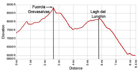
- Elevation: 7,330-ft. - 8,819-ft.
- Elevation Gain: 1,490-ft.
- Difficulty: moderate-strenuous
- Trail Highlights: See Trail Intro
- Basecamp(s): St Moritz
- Region: Eastern Switzerland
Two pretty lakes, a panoramic pass and lovely views of the Albula and Bernina Alps are the scenic rewards of this hike crossing the rugged range between Julier Pass and the Upper Engadine Lakes plateau.
Trailhead to Fuorcla Grevasalvas
Distance from Trailhead: 2.6 miles (one way)
Ending/Highest Elevation: 8,819-ft.
Elevation Gain: 1,490-ft.
Note: Piz in Romansh, a language spoken by some in the Swiss Engadine, means peak, Fuorcla means pass and lej means lake. So Piz Lagrev is Lagrev Peak, Fuorcla Grevasalvas is Grevasalvas Pass and Lej Segl is Lake Segl, or in German the Silsersee. On trail signs you will often see two different names (one in Romansh and one in German) or different spellings for a destination. For example Sils: German and Segl: Romansh.
From St. Moritz, take a bus to Julier, La Veduta. This is the first bus stop after Julier Pass (to the west of the pass). (See trailhead directions below.) Carefully cross to the south side of the road and find the trail signpost near a small pond. Head south/southwest toward Lej Grevasalvas (Lake Grevasalvas), Fuorcla Grevasalvas and Maloja on a trail climbing a grassy hillside on moderate to steep grades. Along the way enjoy great views of the peaks in the Albula ranges rising to the north of the highway. Piz Julier towers beyond the pass to the northeast.
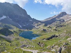
After 0.75 miles the trail crests a grassy knoll and views open to idyllic Lake Grevasalvas (9,613-ft.) cradled in a meadows beneath Piz Lagrev. Piz d’Emmat Dadora and Piz d’Emmat Dadaint rise to the southwest. The pretty aquamarine lake is a popular with people looking for an easy day and a great picnic spot.
From the knoll, a rocky trail drops down to and crosses the outlet stream at the foot of the lake. The path then heads up the Grevasalvas Valley on gentle grades, making a wide arc around the west side of the lake. Along the way the trail crosses a stream draining unseen lakes to the west/southwest of the trail.
Past the stream crossing the path briefly travels atop an old moraine wall before dropping down to cross a creek, typically dry after the snow has melted. Beyond the crossing the trail climbs steeply up rocky ledges along the west side of the narrow valley.
At 1.8 miles the grade abates as the trail travels through an undulating landscape of rocky meadows. Views open to the pass (Fuorcla Grevasalvas), the saddle on the ridge at the head of the valley.
At 2.1 miles the trail starts climbing steeply up rocky meadows. The meadows soon give way to scree-covered slopes and boulder fields. Red/white blazed rocks mark the trail through the boulders. The final push to the pass involves a short, very steep climb up scree covered slopes.
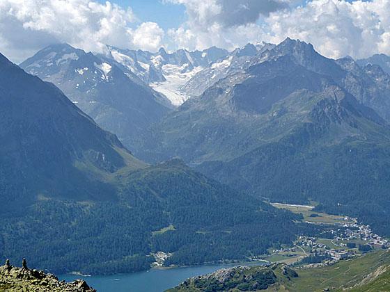
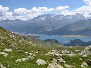
Reach Fuorcla Grevasalvas (8,819-ft.), located on the ridge between Piz Lagrev and Piz d’Emmat Dadaint, at 2.6 miles. Here stunning views open to the glacier-clad, 3,000-meter peaks of the Bernina range towering above the Upper Engadine Valley to the south. Maloja and Lake Sils (Silsersee/Lej da Segl) lies nestled along the valley floor. To the south of Maloja the Forno Glacier spills down a dramatic cirque anchored by Monte Sissone, Torrone and Cima di Castello. Behind you, to the north, the Albula Range fills the skyline.
Fuorcla Grevasalvas to Maloja
Distance from Trailhead: 8.4 miles (one way)
Ending/Highest Elevation: 5,950-ft.
Elevation Gain: -3,542-ft.
After taking a break and enjoying the views, head down the south side of the pass toward Grevasalvas and Maloja. The trail initially drops steeply through talus before leveling out and traveling through boulder fields and then rocky meadows along the south facing slopes of Piz d’ Emmat Dadaint. Pay attention to the red and white markers on the rocks to stay on track through the boulders.
At 3.1 miles the trail begins a very steep descent through pretty meadows with great views of the Bernina peaks towering above Lake Sils. To the west views open to Piz Grevasalvas. Soon the trail turns south as it continues dropping steeply through rocky meadows.
The grade moderates at 3.7 miles as the path descends through rolling pastures and reaches a “T” intersection at Plaun Grand at 4.0 miles. Here hikers have the option of turning left (east) on a trail descending to Plaun da Lej for a 6.3 miles hike or Sils/Segl-Baselgia for a 6.9 miles hike. At Plaun da Lej and Segl/Baseglia hikers can catch a postbus back to St. Moritz. (See below for more information on these alternatives.)
If time, energy and the weather are on your side, I recommend turning right (west) toward Lagh dal Lunghin (Lake Lunghin). The trail to the lake ascends through meadows on easy to moderate grades and soon reaches a junction near a pretty stream. Ignore the trail branching right to Lej Nair, a small lake, and Piz Grevasalvas. Continue on the main trail that now curves to the southwest as it ascending along the right (north) side of a small stream.
At 4.7 miles the trail crosses the stream and then climbs the grassy slopes of a ridge extending southeast from Piz Grevasalvas. As you climb, enjoy great views of the Bernina peaks, Lake Sils and Maloja.
Cross the ridge at 5.2 miles. The narrow trail now curves northwest, contouring along a steep hillside on the west side of the ridge. Use care as the trail crosses several long boulder fields as it ascends on easy grades toward the lake. Soon the trail curves to the left (west) and climbs to the hanging valley where Lagh dal Lunghin (8,169-ft.) lies in a rocky basin beneath Piz Grevasalvas at 5.8 miles. Piz Lunghin rises to the south.
Cross the wood bridge over the outlet stream and then walk along the dam to a trail skirting the south side of the lake. Rocky knolls along the lake shore beckon hikers to sit and take a break.
Soon you will reach a junction. Here a sign points to a path branching right (west) toward Pass Lunghin. We will need to leave that hike for another day. We turn left (south) on the trail descending to Maloja.
Our trail drops on very steep grades from the hanging valley, traveling through rocky meadows with lovely views of the peaks to the south. The grade abates briefly as the trail crosses a wood bridge over the outlet stream for Lake Lunghin at 6.5 miles. Beyond the bridge the trail continues its relentless descent, facilitated by a series of switchbacks.
Reach a junction at Plan di Zoch at 7.5 miles and turn right (south) toward Pila and Maloja. Descend steep switchbacks with great views of Lake Sils and Maloja. At 7.75 miles the grade abates as the trail curves to the right (southwest) and climbs through trees over a low rise, passing the small hamlet of Pila. At Pila the trail joins a broad track that descends to the highway at 8.1 miles.
Cross the highway and turn right (southwest), walking along the sidewalk toward Maloja. The bus stop at Post office in Maloja (5,950-ft.) is located on the west side of the street at 8.4 miles. Here you can catch a bus back to St. Moritz.
Alternate Return via Plaun de Lej or Sils/Segl- Baselgia
For a shorter and easier day, avoid the climb to Lake Lunghin and instead descend from the pass to Plaun de Leg or Sils/Segl-Baselgia. At the "T" intersection at Plaun Grand at 4.0 miles, turn left (east) toward Grevasalvas and Sils/Segl-Baselgia. The path now descends on moderately-steep to steep grades through meadows with more fine views of the peaks rising above Lake Sils. The village of Grevasalvas lies in a meadow-clad bowl below.
At 4.9 mile reach a junction with the Via Engadina trail to Sils/Segl-Baselgia. Here you need to make a choice to bear right toward Grevasalvas or turn left on the Via Engadina trail. The path to Grevasalvas descends through pastures and soon turns right, passing through the pretty little village. Restaurants in the village are popular lunch spots.
At the west end of the village turn left on the broad track dropping down moderate switchbacks to Plaun de Lej (5,900-ft.) at 6.25 miles. Here you can catch a bus back to St. Moritz.
The walk to Sils/Segl-Baselgia is longer but quite pretty, traversing the slopes above the northwest shore of Lake Sils. To reach Sils/Segl-Baselgia, turn left at the junction at 4.9 miles and follow the Via Engadine trail northeast. The path descends through meadows beneath the steep slopes of Piz Lagrev. After passing through a small valley the trail emerges on open slopes with fine views of Lake Sils.
At 5.9 miles the path travels through scattered larches along a rocky hillside. The trail builders did an excellent job laying large, flat slabs along the path to facilitate passage through this area.
Reach at junction at 6.6 miles. Bear right toward Sils/Segl-Baselgia. The path branching left continues along the Via Engadina to Silvaplana. Our path now descends to a "T" intersection along the main highway in the Upper Engadine Valley. Carefully cross the highway and then head south/southeast along a side road into Sils/Segl-Baselgia (5,900-ft.). Look for the bus stop on the left (west) side of the road about 250-ft. from the intersection at 6.9 miles. Here you can catch a bus back to St. Moritz. (See directions below.)
Total elevation loss for the alternate return from the Grevasalvas Pass to Plaun de Lej or Sils/Segl-Baselgia is 2,919-ft.
Elevation Profile
Driving Directions
From St. Moritz Bahnhof to Julier, La Veduta: From the St. Moritz Bahnhof (train station) purchase a ticket for Julier, La Veduta and board bus 182 to Chur. Get off the bus at La Veduta, the first stop after the bus goes over Julier Pass. The ride takes about 30 minutes. (There is a restaurant at this stop called the Ospizio La Veduta.) Carefully cross to the south side of the road where you will find a trail signpost.
From Maloja, Plaun de Lej and Sils/Segl Baselgia to St. Moritz: At the Maloja Post, board a #4 Postbus to St. Moritz Bahnhof (train station). The ride takes about 41 minutes. Note the bus makes a number of stops in St. Moritz on the way to the train station. Check the SBB website or the SBB app to determine the stop nearest to your accommodations.
You can also take a #2 Postbus headed to Pontresina. This option requires you to change to a #1 bus at Silvaplana Post bound for the Samedan Bahnhof. Get off the bus at the St. Moritz Bahnhof or whatever stop is most convenient to your accommodations. The ride takes about 43 minutes.
The #4 and #2 buses also stop at Plaun de Lej and Sils/Segl Baselgia. If you catch the #2 bus, follow the directions above for changing at Silvaplana.
Trail Resources
Trail Intro / Trail Photo Gallery / Trail Map
Basecamp(s) Information:
St Moritz
Region Information:
Eastern Switzerland
Other Hiking Regions in:
Switzerland