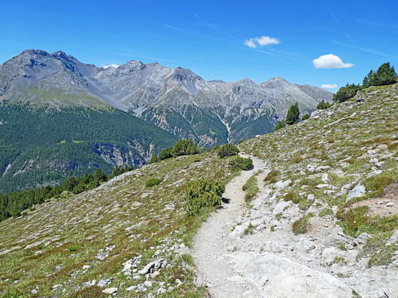
Peaks rimming Val dal Spol
The Munt la Schera trail, in the Biosfera Val Mustair and the Swiss National Park, ascends through scenic meadows sprinkled with wildflowers to the broad summit of Munt la Schera where panoramic views extending to the summits in the Swiss National Park, Italy’s Stelvio National Park and beyond.
See Trail Detail/Full Description
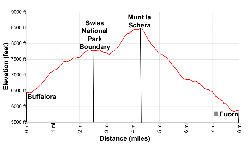
- Distance: 8.0 miles (one way) to Munt la Schera
- Elevation: 6,457-ft. at Trailhead
8,484-ft. at Munt la Schera - Elevation Gain: 2,162-ft. to Munt la Schera
- Difficulty: moderate-strenuous
- More Hikes in:
Scuol / Eastern Switzerland
Why Hike Munt la Schera
The hike to Munt la Schera is one of the most popular hikes in the Swiss National Park and deservedly so. From Buffalora, located in the Biosfera Val Mustair 12 miles (19 km) east of Zernez, the trail quickly climbs above the tree line and then travels through glorious alpine meadows with wonderful views of Piz Nair, Piz Tavru and the nearby peaks in the Sesvenna Alps.
The path then crosses a saddle into the wild and unspoiled landscape of the Swiss National Park. Fine views encompass the peaks in Stelvio National Park in Italy along with summits rising above Val dal Spol in the Swiss National Park.
At a junction along the southern flanks of Munt la Schera, the trail climbs steeply to a ridge leading to the summit. Here far-reaching, panoramic vistas include peaks in the Swiss National Park, Stelvio National Park, the Biosfera Val Mustair and beyond.
Along with the great views, the slopes of Munt La Schera are the home to the elusive Edelweiss, a small flower with furry white petals. The flower, an iconic image in Switzerland, is a protected plant in many cantons. Please do not pick or disturb this pretty flowers.
Park regulations require hikers to stay on marked trails and picnic in designated rest stops. Dog, camping, fires and the leaving of trash are prohibited.
Don’t attempt this hike in poor weather or if the weather is threatening to take a turn for the worse. Much of the hike is on expose slopes, not the place to be in a thunderstorm.
Elevation Profile
| Support our Site |
Trail Resources
Trail Detail/Full Description / Trail Photo Gallery / Trail Map
Basecamp(s) Information:
Scuol
Region Information:
Eastern Switzerland
Other Hiking Regions in:
Switzerland