Hike Facts
- Distance: 8.4 miles (round trip)
- Elevation: 6,099-ft. - 8,986-ft.
- Elevation Gain: 2,887-ft.
- Difficulty: moderate-strenuous
- Trail Highlights: See Trail Intro
- Basecamp(s): Davos
- Region: Eastern Switzerland
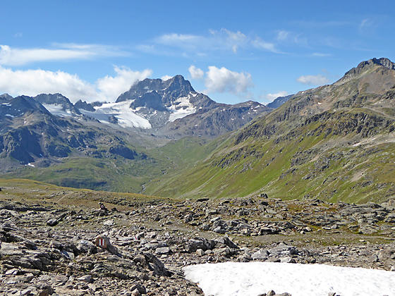
Ascend a bucolic valley and then scree-covered slopes to scenic Sertig Pass with terrific views of the cirque rimming the Tschuvel Valley. Along the way enjoy fine views of the summits rimming the Ducan and Chuealp valleys including the Mittaghorn, Chuealphorn and Bocktenhorn.
Sertig to Sertig Pass
Take the bus from Davos to Sertig Sand (see trailhead directions below). The bus stops in front of the Walserhuus Restaurant/Hotel in Sertig Sand (6,099-ft.). Walk south along the road skirting the east side of the restaurant, past the parking lot (left). The trail signpost is just beyond the parking lot. Continue straight ahead on the alp road toward Chuealp, Sertigpass, Scalettapass and Durrboden.
The trail ascends on easy grades through pastures along the east side of the valley. The Sertigbach, a pretty stream, meanders down the idyllic valley beside the trail. Ahead the Mittaghorn, Plattenflue and Piz Duncan, rising along the southeast side of the Ducan Valley, dominate the view.
Reach a “Y” intersection at 0.4 miles and turn left (southeast) up the Chuealp Valley toward Sertig Pass. The trail to the right (south) ascends the Ducan Valley to the Fanezfurgga and Monstein. See the Sertig to Monstein hike for more information.
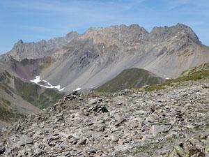
Follow the trail as it ascends the dirt road on moderate grades. Behind you the Alplihorn and Leidbachhorn tower above the west side of the Sertig Valley.
At 1.4 miles views open to the rugged Chuealphorn at the head of the Chuealp Valley. The Mittaghorn soars above the trail to the west while the delightful Chuealpbach flows along a rocky streambed to the right (west) of the trail.
Pass a barn/milking station at 1.7 miles and then reach a junction at 2.4 miles near Grunsee (7,208-ft.), a small tarn. Here the road ends. Bear right on the trail crossing a wood bridge over the Chuealpbach. Beyond the bridge the path climbs steeply through pastures along the west side of the valley. A second smaller bridge at 2.4 miles keeps your feet dry while crossing a stream cascading down the steep, grassy slopes above the trail.
The trail now climbs a few switchbacks and then continues on a diagonal up the west side of the valley. As you ascend enjoy ever improving views of the rugged cirque at the head of the valley. Behind you the Bocktenhorn dominates the view to the northeast.
Soon meadows give way to scree-covered slopes. At 3.9 miles views open to Sertig Pass, the saddle on the ridge at the head of the valley. Nestled in a depression below the trail is a small tarn, covered in ice/snow early in the season.
The trail now climbs steeply up the west side of a rocky bowl to Sertig Pass (8,986-ft.) at 4.2 miles. As you crest the pass Piz Kesch (11,214-ft.), the highest peak in the Albula Alps, burst onto the scene to the south. The Porchabella Glacier flows down the flanks of this majestic peak, soaring above the head of the Tschuvel Valley, while Piz Murtelet and Piz Forun rim the valley to the west. The serrated peaks of the Ducan Ridge fill the skyline to the west of the pass.
The pass is a great place to take a break and enjoy the views. Most parties turn around at this point and retrace their steps to Sertig Sand. If you have the time and energy, along with good weather, I highly recommend continuing over the Sertig Pass to Scaletta Pass and Durrboden. See the Sertig to Durrboden hiking description for more information.
Elevation Profile
Driving Directions
Davos to Sertig: From the Bahnhof (train station) at Davos Platz (the southwest end of town), board the bus to Sertig. Purchase a ticket for Sertig Sand, the last stop on the line. The scenic ride up the Sertig Valley takes about 27 minutes. Regularly scheduled buses return to Davos via the same route. A schedule is posted at the bus stop of Sertig Sand. You can also check the current schedules at the SBB website/SBB app.
Note: Buses and trains travel between Davos Dorf and Davos Platz. The train ride takes three minutes. Buses take a variety of routes through the town. Pick up a bus schedule at the Tourism Office at the Davos Dorf Bahnhof or near the Sportzentrum in the middle of town, or consult the SBB website/SBB app to find the stop closest to your accommodations.
Trail Resources
Trail Intro / Trail Photo Gallery / Trail Map
Basecamp(s) Information:
Davos
Region Information:
Eastern Switzerland
Other Hiking Regions in:
Switzerland