Fluela Pass – Schwarzhorn - Durrboden 
Distance: 6.4 - 8.1 miles (one way)
near Davos in Eastern Switzerland
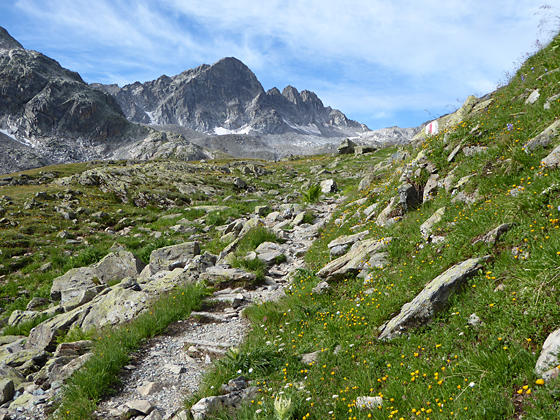
First views of Piz Radont
This epic hike summits the Schwarzhorn, crosses two panoramic passes and visits four scenic valleys in route to Durrboden. Highlights include the high peaks towering above the Lower Engadine, the cirque at the head of the Grialetsch Valley and the summits rimming the Dischma, Funtauna and Tschuvel Valleys.
See Trail Detail/Full Description
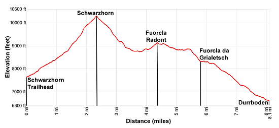
- Distance: 2.3 miles (one way) to Schwarzhorn
4.3 miles (one way) to Fuorcla Radont
8.1 miles (one way) to Durrboden - Elevation: 7,817-ft. at Trailhead
10,318-ft. at Schwarzhorn
9,137-ft. at Fuorcla Radont
6,620-ft. at Durrboden - Elevation Gain: 2,501-ft. to Schwarzhorn
380-ft. to Fuorcla Radont
-2,562-ft. to Durrboden - Difficulty: strenuous-difficult
- More Hikes in:
Davos / Eastern Switzerland
Why Hike Fluela Pass – Schwarzhorn - Durrboden
This challenging hike climbs to the summit of the Schwarzhorn with breathtaking, 360-degree views of the high peaks in northeastern Graubunden and beyond. After descending from the summit the trail crosses a rugged bowl beneath the Raduner Rothorn and Piz Radont before ascending to Fuorcla Radont (Radont Pass). Views from the pass encompass the summits rising above the Grialetsch Valley and the splendid cirque at the head of the valley anchored by Piz Sarsura, Piz Vadret and Piz Grialetsch.
The views of the Grialetsch valley continue as the trail descends to Fuorcla da Grialetsch (Grialetsch Pass). This lovely spot, set amid a meadow clad bench with two small tarns, features close-up views of the Grialetsch cirque.
Beyond the pass the trail drops into the Furgga Valley where fine views extend up the Dischma Valley to the Scaletta Pass area. The final leg of the trail descends to Durrboden where the peaks rimming the Gletschtalli Valley and the Scaletta Glacier are the stars of the show.
Pick a day full of promise before attempting this hike. There is a lot of up and down along rugged trails with over 3,000-ft. of elevation gain and more than 5,000-ft. of elevation loss. Keep an eye on the time so you don’t miss the last bus from Durrboden back to Davos.
Elevation Profile
| Support our Site |
Trail Resources
Trail Detail/Full Description / Trail Photo Gallery / Trail Map
Basecamp(s) Information:
Davos
Region Information:
Eastern Switzerland
Other Hiking Regions in:
Switzerland