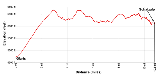
Details: Davos Alpentour – Glaris to Schatzalp 
Distance: 10.8 miles (one way)
near Davos in Eastern Switzerland
Hike Facts
- Distance: 10.8 miles (one way)
- Elevation: 4,734-ft. - 6,670-ft.
- Elevation Gain: 1,936-ft. - 1,936-ft.
- Difficulty: moderate-strenuous
- Trail Highlights: See Trail Intro
- Basecamp(s): Davos
- Region: Eastern Switzerland
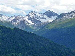
This lovely walk traverses above or near the timberline along the west side of the Davos Valley with fine views of the peaks towering above the east side of the valley and the summits rimming the ridge to the west. Alternative destinations allow hikers to easily shorten the walk.
Davos Alpentour – Glaris to Schatzalp
From the bus stop at Glaris Ortolfi (see trailhead directions below), walk north (toward Davos) a short distance and turn left on the first street with a bridge over the river. The street is just to the south of the Hotel Post. Here you will find trail signs for the Davoser Alpentour heading toward Barentaler Alp, Stafelalp and Davos Platz. At all junctions stay on the Alpentour toward Stafelalp.
After crossing the river on a bridge, bear left on a road and then follow the trail signs for the Alpentour. The route winds up through Glaris, passing typical Walser farmhouses set amid pastures. At 0.4 miles the road crosses the Baretalbach (stream) on a bridge. Soon signs point left (west/northwest) to a track climbing on moderate to moderately-steep grades up the Baretal Valley along the north side of the stream.
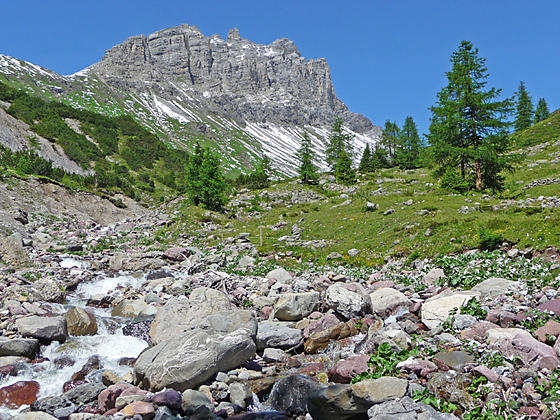
The Baretal Valley is one of the larger tributary valleys that branches off the main Davos Valley in a westerly direction. As you ascend the valley note the profusion of dwarf mountain pines.
At 0.7 miles we leave the roads behind and continue ascending on a trail through trees and intermittent meadows. Openings offer views of Strel, rising along the ridge rimming the west side of the Landwasser Valley. Below the trail the Baretalbach cascades down a rocky creek bed. Behind you (east) the Rinerhorn towers above the east side of the Davos Valley
At 1.6 miles the trees give way to meadows. A short distance beyond the trail curves to the right, rejoining a farm track. Ahead views open to Barentaler Alp. To the east are lovely views of the Rinerhorn and Alplihorn.
Soon we reach a junction at Barentaler Alp. Here the Alpentour turns left on another farm track heading up the valley.
At 2.0 miles turn right (northeast) at a junction toward Chummeralp and Stafelalp. From here until Schatzalp the Alpentour will follow an undulating traverse along the west side of the valley near or above the timberline, curving in and out of side valleys.
The trail now continues its ascent through scattered trees and meadows with fine views of the peaks rimming the east side of the Landwasser Valley. At 2.9 miles reach the first of two high points (6,670-ft.) on the trail, located along the east ridge of the Amselflue. Turn around and look west/southwest for good views of Strel and Valbellahorn.
The path now descends on moderate to moderately-steep grades into the Chummertalli Valley, another tributary valley branching west off the Landwasser Valley. Meadows offer views of the Schwarzhorn and Chummerhureli rising above the north side of the valley. The Amselflue towers above the head of the valley to the west.
At 3.7 miles the path crosses the Chummerbach on a bridge and then ascends on moderate grades up the valley's north slopes accompanied by more good views of the Amselflue. Along the way, signs point to a trail descending to train/bus stops in Frauenkirch and Glaris. These are just the first of several trails where parties looking to cut the hike short can descend to the Landwasser Valley floor and return to Davos.
At 4.6 miles we reach Chummeralp, the location of a hut dating back to the 19th century. The Alp enjoys terrific views of the surrounding peaks. Beyond the alp the trail climbs to the second high point (6,670-ft.) on the Alpentour, located atop the ridge extending east from the Chummerhureli.
The path now descends through pretty meadows, crossing a few small drainages along the way. Signs for the Alpentour point toward Stafelalp, Erbalp, Schatzalp and Davos Platz. Behind you are views of the Chummerhureli, Schwarzhorn and Tiejer Flue.
At 5.6 miles the trail crosses a bridge over the Sutzibach and then drops down to Stafelalp at 6.1 miles. The village contains many traditional houses including the Berghaus Stafelalp, which is around 250-years old. The building now houses a small inn and a restaurant. Stafelalp is another good place to cut the hike short. Here you will find trails descending to Frauenkirch, where buses and trains return to Davos.
Beyond the alp the trail curves around a shallow side valley and then travels through scattered trees and meadows, passing through the small hamlet of Assererb. Reach a junction at 7.4 miles, five-minutes from Erb Alp. The trail branching right descends to Davos Platz, another option for shortening the hike. We continue along the Alpentour, passing through Erb Alp on the way to Gruenialp and Schatzalp.
The path now ascends on moderate grades through meadows. To the east/southeast, views open to the high peaks towering above the Sertig Valley, a tributary valley branching southeast off the Landwasser Valley.
At 8.0 miles the trail crests a low ridge and views open northwest to Strela and the Chupfenflue. After crossing the Bildjibach on a bridge, the path descends on moderately steep grades to Gruenialp at 8.5 miles. Trails branching to the right drop down to Davos Platz.
Beyond Gruenialp, the undulating Alpentour heads toward Schatzalp, traveling through meadows with fine views to the north/northeast of Davos, the Davosee and the high peaks rising above Klosters and the Durrboden Valley. Along the way the trail dips in and out of several minor drainages before cross a tributary of the Albertibach.
At 9.3 miles the trail drops into a rocky gully and crosses the Albertibach on a bridge. As the trail ascends out of the drainage it enters the trees, climbing above a landslide and then descending to a pretty meadows with great views of the Alplihorn, Mittaghorn and Piz Ducan towering above the Sertig Valley.
The views are short lived. Soon the path plunges back into the trees and descends switchbacks to Schatzalp. This segment of the trail crosses the Guggerbach on a bridge and passes trails branching left to the Alpinum (Botanic Garden), which boasts a collection of approximately 5,000 plant species from mountains all around the world.
Walk through the hotel complex to the funicular station and the end of the Alpentour at 10.8 miles. The funicular descends to Davos Platz where buses connect to location in Davos Platz and Davos Dorf.
Elevation Profile
Driving Directions
From the Davos Dorf Bahnhof to Glaris Ortolfi: Take the #1 bus heading toward Glaris and get off the Glaris Ortolfi. The ride should take 21 minutes. You can check the current bus schedules at the SBB website/SBB app to find the stop along the #1 route nearest to your accommodations.
From Schatzalp to Davos Dorf Bahnhof: Take the funicular from Schatzalp to the bottom station. Catch a #1 or 3 bus headed to Davos Dorf. Get off the bus at at the Davos Dorf Bahnhof. You can check the current bus schedules at the SBB website/SBB app to find the stop nearest to your accommodations.
If walking the hike in reverse:
From Davos Dorf Bahnhof to Schatzalp: From the Davos Dorf train station, take the #1 or 3 bus heading to Davos Platz and get off at the Davos Platz Schatzalpbahn (the funicular in Davos Platz climbing to Schatzalp). Purchase a one-way ticket to the Schatzalp. You can check the current bus schedules at the SBB website/SBB app to find the stop nearest to your accommodations.
Trail Resources
Trail Intro / Trail Photo Gallery / Trail Map
Basecamp(s) Information:
Davos
Region Information:
Eastern Switzerland
Other Hiking Regions in:
Switzerland