First to the Faulhorn 
Distance: 7.2 miles
Bernese Oberland, near Grindelwald in The Bernese Oberland
High peaks to the southwest: Eiger, Monch, Junfrau and the Breithorn
Amazing views of the glacier clad peaks towering above Grindelwald and Lauterbrunnen along with views of Lake Brienz and beyond are the highlights of this popular trail climbing to the historic Faulhorn Berghaus and the summit of the Faulhorn.
- Distance: 7.2 miles (RT)
- Elevation: 7,110-ft. at Trailhead
Maximum elevation - 8,793-ft. - Elevation Gain: 1,683-ft.
- Difficulty: moderate-strenuous
- Basecamp: Grindelwald
- Region: The Bernese Oberland
Trail Description - First to the Faulhorn
This great hike starts with a scenic gondola ride to First and then travels along the well-trod path to the beautiful Bachsee. Along the way the Wetterhorn, Schreckhorn and the Eiger are the stars of the show, soaring above the Grindelwald Valley.
Beyond the lake the trail climbs to the grassy saddle at Gassenboden (8,373-ft.) where views open to the summits towering above Lauterbrunnen. Our destination, the Faulhorn, is in sight. Beyond the saddle a steep climb leads to the historic Faulhorn Berghotel, situated just below the summit of the Faulhorn. From the hotel and the summit of the Faulhorn enjoy grand views of the Bernese Alps to the south and the Lake Brienz area to the north. The hotel offers rooms and dormitory accommodation along with meals.
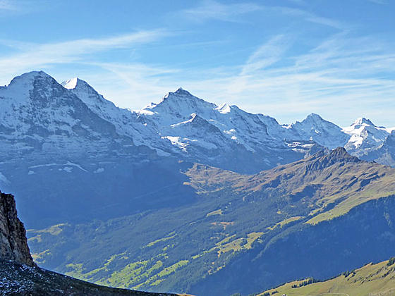
An optional extension beyond the Faulhorn junction leads to a stunning overlook with views encompassing the glacier clad peaks soaring above Grindelwald and Lauterbrunnen. On a beautiful day it will be hard to pull yourself away from the stunning views.
First to the Bachsee
First (7,110-ft.) is situated atop a minor summit high above the north side of Grindelwald. Overlooks at First feature stunning views of the summits soaring above the Grindelwald Valley, including the Wetterhorn, Schreckhorn and Eiger. Glaciers spill down the flanks of these massifs to deep incised gorges. Views extend southwest to Klein Scheidegg and the Jungfrau and southeast to the peaks rising beyond Grosse Scheidegg.
The facilities around First include a popular restaurant with a sun terrace and a “Cliff Walk”, a cantilevered metal walkway bolted to the sheer west face of the First summit that leads to a 150-ft. long viewing platform with panoramic views of Grindelwald’s iconic 4,000-meter peaks. The walkway connects with the restaurant’s sun terrace where signs identify the mountains.
After taking in the views at First, start the hike by walking behind the First restaurant and lift station where you will find a trail signboard. Walk northwest toward the Bachalpsee (50-min), Faulhorn (2-hr 20-min) and Schynige Platte (5-hr) on a wide gravel track ascending through meadows on moderate grades. The trail enjoys non-stop, ever evolving views. To the southeast the Grindelwald Glacier tumbles in motionless waves down the slopes of the Wetterhorn, Barglistock and Schreckhorn. To the south the Finsteraarhorn towers beyond the glacial cirque formed by the Fiescherhorn, Monch and Eiger. To the west Reeti rises above the bowl cradling the Bachsee (aka Bachalpsee), the destination for this hike.
After 0.7 miles the grade eases and the trail soon curves to the left (west) through lovely meadows toward the Bachsee. At 1.6 miles the path reaches a junction where a trail branches right toward the Hagelsee and Wildgarst. Stay on the main track to the Bachsee. A short distance beyond pass a second junction with a path heading left (south) toward Waldspitz, Bort and Grindelwald.
At 1.9 miles arrive at a trail junction at the southeastern end of the Bachsee (7,431-ft.). The lake is split in two by a natural dam, with the lower lake located 20-ft. below the upper lake. On a calm day the Schreckhorn is perfectly reflected in the lower-lake’s mirror-like surface. Views extend west across the upper lake to the Faulhorn, Esel and Simelihorn rising above the cirque at the head of the valley. The lake basin is a popular picnic spot and a favorite destination for parties looking for an easy hike. Get an early start to avoid the crowds.
Bachsee to the Faulhorn
After exploring the area around the Bachsee return to the junction. Ignore the trail heading left (southwest) to Spitzen, Feld and Bussalp. Instead turn right (northwest) on the trail toward the Faulhorn (1-hr 30-min), which skirts the right (northeast) shore of the Bachsee.
At the northwest end of the lake the trail curves to the left (west/northwest) and starts a steep ascent through rocky meadows toward a saddle. Switchbacks facilitate the ascent. As you climb turn around for beautiful views of the Wetterhorn and Schreckhorn forming the perfect backdrop for the Bachsee. To the east views open to the Schwarzhorn rising to the north of Grindelwald.
Reach the broad, grassy saddle at Gassenboden (8,373-ft.) at 3.1 miles. Here signs points to a path dropping southwest toward Bussalp. Our trail curves to the right (north) and climbs toward the Faulhorn (25-min), Manndlenen (1-hr 10-min) and Schynige Platte (3-hr 10-min). Panoramic views from the saddle encompass a sea of peaks to the southwest including the Jungfrau, Breithorn and, in the distance, the Bluemlisalp massif. The Faulhorn rises to the north.
Beyond the saddle the trail continues the steep climb, arriving at the Faulhorn junction (8,596-ft.) at 3.4 miles. Turn right (north) on the trail switchbacking up steep, grassy slopes to the Berghaus Faulhorn and the summit of the Faulhorn (8,793-ft.) at 3.6 miles. The stiff climb is rewarded with grand views of the Bernese Alps to the south and the Lake Brienz area to the north. The Faulhorn offers rooms and dormitory accommodations in addition to the restaurant with a deck boasting amazing views of the high peaks to the south.
Overlook Beyond the Faulhorn
If time and energy permit, I strong encourage hikers to descend to the junction below the Faulhorn and then walk 0.4 miles west along the trail toward Manndlenen (1-hr) and Schynige Platte (3-hr). The narrow trail initially drops steeply across the south facing flanks of the Faulhorn. After 0.2 miles the grade eases as the path travels west along a ridge and then climbs a low grassy knoll. Near the top of the knoll watch for red/white blazed rocks marking a turn to the right. (There is no sign.) Here a use-trail continues straight ahead along the top of the knoll to excellent lunch spots with stunning views of the peaks towering above Grindelwald, Lauterbrunnen and beyond. When you are done taking in the views retrace your steps to the Faulhorn junction and then the First gondola. Total round trip distance for this detour is 0.8 miles.
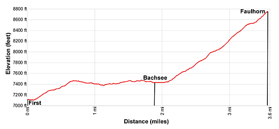
Elevation Profile
Driving Directions
From the Grindelwald Bahnhof (train station) to First Gondola: Walk east along Dorfstrasse, the main street in Grindelwald for 0.4 miles. Turn left on an unnamed street across from the vehicle entrance for the Sunstar Hotel. The turn is marked with a sign for the Firstbahn (First Gondola). (If you pass the Gasthof Steinbock with a pizzeria on the ground floor you have gone too far.) Walk up the street to the First Gondola station, just past the Pension Gydisdorf.
Note: The First gondola it a multi-stage lift that goes through intermediate stations. At all stations remain seated. The doors will open, allowing passengers who wish to get off at the intermediate stations to leave the gondola, and then close before continuing the journey to First.
When purchasing lift tickets it is typically less expensive to purchase a round-trip ticket than two one-way tickets.
Trail Resources
- Trail Photo Gallery
- Trail Maps
- Basecamp(s) Information: Grindelwald
- Region Information: The Bernese Oberland
- Other Hiking Regions in: Switzerland