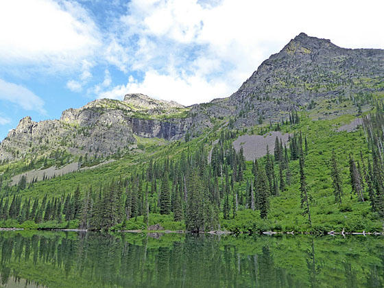
Mt. Brown towering above Snyder Lake
This pleasant jaunt leads to pretty Snyder Lake set amid a rugged cirque. The trail is a nice early season option and offers a good workout. Areas burnt by the 2017 fire are recovering and now feature good views of the surrounding peaks.
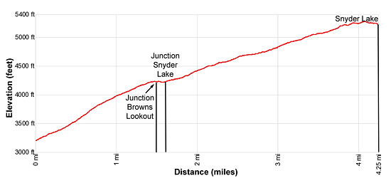
- Distance: 8.5 miles (RT)
- Elevation: 3,200-ft. at Trailhead
Maximum elevation - 5,280-ft. - Elevation Gain: 2,080-ft.
- Difficulty: moderate
- Basecamp: Lake McDonald
- Region: Glacier Natl Park, MT
Trail Description - Snyder Lake
The trail starts at the Gunsight Pass trailhead near Lake McDonald Lodge (see driving directions below). A short distance from the trailhead the path passes to the south of a horse stable and the junction with the Avalanche Trail, branching left (north).
Beyond the junction the trail ascends through a forest of western hemlocks, red cedars and larches on moderately steep grades along the north side of the Snyder Creek drainage. Along the way are a few short, steep climbs. After a mile the path enters the area burnt by the Sprague Fire in 2017. The fire left a patchwork of trees with some areas burnt and others untouched. The result is a more open trail that offers better views of the surrounding area but is more exposed to the sun and hotter.
As you climb, turn around in the open areas for good views of the Howe Ridge rising above the west side of Lake McDonald. After 1.5 miles the grade abates as the trail reaches the junction with the Mount Brown Trail, heading left (north). At 1.6 miles reach the junction with the Snyder Lake Trail branching left (northeast).
Turn left on the Snyder Lake Trail. The path now climbs through dense ground cover on easy to moderate grades along the west side of Snyder Creek. Dead trees along the trail clearly indicate the progress of the fire up this side valley.
At 1.9 miles the grade steepens a bit, making a steady climb for the rest of the way to the lake. At 3.7 miles the remaining trees start to thin as the trail crosses a talus slopes along the lower east facing flanks of Mount Brown (7,487-ft.). Look up for you first good views of the peak. Beyond the talus the trees give way to pretty meadows sprinkled with wildflowers. Ahead the Little Matterhorn (7,886-ft.) dominates the view at the head of the valley. Mount Brown looms above the valley to the northwest.
Reach pretty Snyder Lake (5,220-ft.) at 4.25 miles. The dark green lake lies at the base of a rugged cirque formed by Mount Brown, the Little Matterhorn and Edwards Mountain (9,072-ft.). About 40-percent of the trees around the lake are now dead due the fire, improving the views of the surrounding peaks and colorful ridges ringing the lake.
A use trail weaves around the south side of the lake, passing the campground along the way. Rocks along the shore offer nice perches for taking a break or enjoying a picnic lunch. The area is filled with mosquitos early in the summer. Make sure you bring some bug juice.
After enjoying the lake, return the way you came.
Elevation Profile
Driving Directions
From West Glacier, MT: From the junction of US-2 and the Going-to-the-Sun Road, turn northwest on the Going-to-the-Sun Road and follow the road 2.0 miles. Turn right at the junction with the Apgar Visitor Center to stay on Going-to-the-Sun Road. Continue for 8.9 miles. A crosswalk across the road signals the beginning of the Gunsight Pass/Sperry Chalet Trail on the right (east). This is the trailhead to Snyder Lake.
Take the next left on an unmarked one-way road with a tiny wood building and bus shelter at the corner. Along this road you will find parking for the Lake McDonald Lodge and the trailhead. At the first intersection turn left on the road that runs parallel to the front of the Lodge. A short distance beyond take your next left on a one-way road heading back to the Going-to-the-Sun road. This road also includes parking for the Lake McDonald Lodge and the trailhead. Find a parking spot along the road and then walk the rest of the distance up the road to the Going-to-the-Sun Road. Carefully cross the Going-to-the-Sun Road using the crosswalk. The trailhead for the Gunsight Pass trail to Snyder Lake and Sperry Chalet is on the east side of the road.
The parking lots around the Lake McDonald Lodge can be very congested. Typically in the morning, when people are checking out, you should be able to find a space. Alternatively, take the shuttle bus from the Apgar Visitor Center, a better option during the height of the summer when parking is limited.
Trail Resources
- Trail Photo Gallery
- Trail Maps
- Basecamp(s) Information: Lake McDonald
- Region Information: Glacier Natl Park, MT
- Other Hiking Regions in: Montana