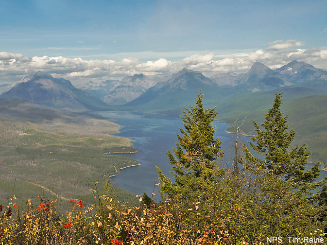
This nice hike ascends to an old fire lookout atop a shoulder of Apgar Mountain with partially obstructed birds-eye-views of the Lake McDonald area.
- Distance: 7.2 miles (RT)
- Elevation: 3,356-ft. at Trailhead
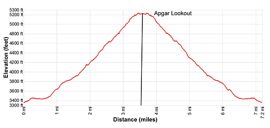
Maximum elevation - 5,236-ft. - Elevation Gain: 1,880-ft.
- Difficulty: moderate
- Basecamp: Lake McDonald
- Region: Glacier Natl Park, MT
Trail Description - Apgar Lookout
From the parking area (see driving directions below) the trail, actually an old two-track road, briefly ascends on easy grades and then flattens out as it passes through forest of lodgepole pines growing in a marshy area. A few small creeks flow across the road. The stumps in the woods are the reminders of a wildfire the charred that area in 1929.
After 0.7 miles the trails starts ascending on moderate grades. At 1.3 miles the road gives way to a trail and the grade briefly abates. Soon the ascent resumes with the trail climbing three long moderate to moderately steep switchbacks up the southwest facing slopes of Apgar Mountain.
The 2003 Roberts Fire decimated most of the trees along the slope, opening views to the south. Along the way pass a few pockets of spruce trees. Reach the old fire lookout (5,236-ft.), located on a shoulder to the southeast of the summit, at 3.6 miles. The lookout, built in 1929, is now listed on the National Register of Historic Places. Trees and a communication tower partly impede the views.
From the lookout, views stretch up the length of Lake McDonald to the high peaks towering above the head of the lake. Stanton Mountain (7,750-ft.), Mount Brown (7,487-ft.), Mount Cannon (8,952-ft.) and the summits along the Garden Wall (Continental Divide) are visible on a clear day. Edwards Mountain (9,072-ft.), Gunsight Mountain (9,258-gt.) and Mount Jackson (10,052-ft.) rise to the east of Mount Brown. Rogers Peak (7,340-ft.), the Dutch Ridge (7,670-ft.) and Wolf Gun Mountain (8,020-ft.) rise to the northwest of Stanton Mountain. The burnt area to the west of Lake McDonald is the result of the 1967 Camas Fire and the 2003 Roberts Fire.
The hike is a good option during the shoulder season when snow blankets the high country or to help hiker acclimate. The trail is best hiked in the afternoon otherwise you will be looking right into the rising sun. Be forewarned that the open slopes make this a very hot hike. Wear and hat and take plenty of water.
Elevation Profile

Driving Directions
From West Glacier, MT: From the junction of US-2 and the Going-to-the-Sun Road, turn northwest on the Going-to-the-Sun Road. Follow the road for 1.2 miles and then turn left toward the Glacier Institute. Drive for 0.3 miles to a “T” intersection and bear right. (The Glacier Institute is to the left.) A short distance past the intersection the road reaches a “Y” intersection just before the Swan Mountain Outfitters Corral. Bear left here onto a narrow gravel road. The road soon crosses the Middle Fork of the Flathead on a bridge. Follow the road for 1.9 miles to the Apgar trailhead parking lot. Along the way you will pass another “Y” intersection where you should stay left. The trailhead is located on the northwest side of the parking area.
Trail Resources
- Trail Photo Gallery
- Trail Maps
- Basecamp(s) Information: Lake McDonald
- Region Information: Glacier Natl Park, MT
- Other Hiking Regions in: Montana
