Details: Ptarmigan Tunnel 
Distance: 11.0 miles (round trip)
Glacier National Park, near Many Glacier in Glacier Natl Park, MT
Hike Facts
- Distance: 11.0 miles (round trip)
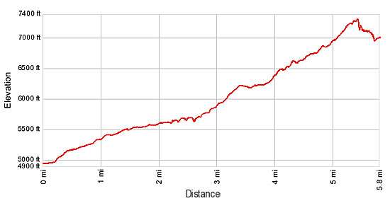
- Elevation: 7,360-ft. - 4,940-ft.
- Elevation Gain: -2,420-ft.
- Difficulty: moderate-strenuous
- Trail Highlights: See Trail Intro
- Basecamp(s): Many Glacier / St Mary
- Region: Glacier Natl Park, MT
This moderately strenuous hike ascends to a tunnel piercing the Ptarmigan Valley’s knife-edge headwall with stunning views of the peaks soaring above Many Glacier area to the south and the Belly River Valley to the north.
Ptarmigan Tunnel
Please note: This trail passes through prime bear habitat. Keep an eye out for bears foraging along the avalanche slopes above the trail. Make noise while hiking, especially through areas of dense vegetation to insure you do not accidently surprise a bear. Park rangers are now advising hikers to carry bear spray while hiking.
From the Iceberg Lake/Ptarmigan Tunnel trailhead (see driving directions below), follow the trail as it heads north climbing steeply up rocky ledges, through meadows and stands of trees. In a short distance the trail passes a spur trail, branching to the right, heading back to the Swift Current area and Many Glacier Hotel. Bear left, staying on the main trail. At 0.2 miles the grade abates as the trail reaches a second junction. Follow the main trail as it curves to the left (northwest). The trail to the right (southeast) leads to the Many Glacier Hotel.
For the next 2.3 miles the trail ascends on easy to moderate grades through pretty meadows and forest along the lower slopes of Mt. Henkel (8,770-ft.). The first 0.75 miles of this section crosses wildflower-filled meadows with wonderful views to the west of Mt. Grinnell (8,851-ft.), Swiftcurrent Mountain (8,436-ft.) and Mt. Wilbur (9,321-ft.) towering above the beautiful Swiftcurrent Valley. Ahead the jagged profile of the Ptarmigan Wall rims the head of the Wilbur Creek drainage. Turn around for views of Allen Mountain (9,276-ft.) to the south.
At 1.8 miles the trail enters the forest. Small meadows and openings in the trees offer intermittent views of the surrounding peaks. Be sure to stop at the viewpoint for Ptarmigan Falls (5,659-ft.) at 2.45 miles. Trees partially obscure the view of the fall across the deep drainage.
Past the viewpoint the trail loops around the east side of the drainage and crosses a bridge over Ptarmigan Creek, the source of the falls. Rocking outcroppings above the falls to the southeast of the bridge offer a nice place to take a break and sit in the sun.
Beyond the bridge the trail continues its ascending traverse, reaching a junction with the trail to the Ptarmigan Tunnel, branching to the right, at 2.6 miles. (The trail continuing straight ahead leads to Iceberg Lake.) Turn right, following the Ptarmigan Trail as it ascends north on steep/moderately-steep grades through forest along the west side of the Ptarmigan Creek valley.
At 3.2 miles the trees thin and views open to the craggy slopes of the Ptarmigan Wall towering above the west side of the valley. Crowfeet Mountain (8,914-ft.) rims the valley’s eastern wall. For the next half mile the trail passes through lush meadows and stands of trees on easy grades.
The climb resumes on moderately steep grades at 3.7 miles, traveling through meadows and groves of stunted conifers. As you ascend be sure to turn around for good views down the valley of Mt. Wilbur (9,321-ft.). The top of Mt. Grinnell (8,851-ft.) is also seen rising in the distance.
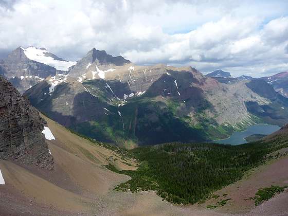
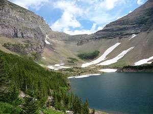
At 4.4 miles views open to Ptarmigan Falls tumbling over a series of rock ledges. A tenth of a mile beyond the falls Ptarmigan Lake springs into view. The pretty aquamarine lake is surrounded by sheer, rugged cliffs and scree-covered slopes. Look north to see the steep trail switchbacking up the talus slopes of the valley’s headwall. The Ptarmigan Tunnel is located beneath the low point on the headwall.
Follow the trail as it ascends along the slope above the west side of the lake on moderately steep grades. Beyond the head of the lake the grade steepens as the trail climbs long switchback across scree-covered slopes. As you ascend, watch for mountain goats and big horn sheep climbing along the cliffs above the trail.
Reach the south entrance for the Ptarmigan Tunnel (7,260-ft.) at 5.2 miles. The 250-ft. long tunnel, completed in 1930, was built to facilitate the transit of guides and tourist horses between the Belly River country and the Many Glacier area. Contractor Ole Westman and his crew excavated the passage through the mountain with two jackhammers and a series of ten-hole rounds of dynamite. Rock removed from the tunnel was used to line the interior walls, frame the openings and build retaining walls along the tunnel entrances on both sides of the mountain. Heavy iron doors where hung across the entrances to the Tunnel in 1975 to permit the sealing of the passage from October through early July.
From the high vantage point at the south entrance of the tunnel stunning views extend down the Ptarmigan Creek Valley to a sea of peaks rising above Many Glacier. To the west the sheer cliffs and rugged ridge of the Ptarmigan Wall towers above Ptarmigan Lake. Mt. Wilbur and Mt. Grinnell frame the skyline to the southwest.
After taking in the views on the south side walk through the tunnel. Emerging on the north side of the tunnel you are greet with wonderful views of the Belly River Valley. Elizabeth Lake is nestled in the valley floor while Natoas Peak (9,360-ft.) and the Crosley Ridge towering above the western side of the valley. Nearer at hand you can’t help but marvel at the incredible cliffs and craggy pinnacles looming above north tunnel entrance.
It is definitely worth the time and effort to walk down the trail on the north side of the tunnel for 0.3 to 0.5 miles for spectacular views of Ipasha Peak (9,572-ft.), Mount Merritt (10,004-ft.), Natoas Peak and the Old Sun Glacier, the large snowfield flanking the east face of Mount Merritt, rising to the west. Elizabeth Lake lies beneath the peaks and ridges rimming the west side of the Belly River Valley.
After taking in the breathtaking views day hikers will need to turn around and retrace their steps to the Iceberg Lake/Ptarmigan Tunnel trailhead near the Swiftcurrent Motor Inn. Backpackers lucky enough to secure backcountry permits can continue descending the trail to a junction near the foot of Elizabeth Lake, 9.8 miles from the trailhead.
Note: Before starting your hike ask about current trail conditions at the Many Glacier Ranger Station. Trails in the Many Glacier area are occasionally closed due to bear activity. The Ptarmigan Tunnel is typically open from mid-July to October 1st. Check with the ranges to make sure the tunnel is open and the trail passable before starting your hike.
Elevation Profile
Driving Directions
From St. Mary: Drive north on US 89 for 8.5 miles and turn left onto Route 3, signed for Many Glacier. The turn is just before the town of Babb, MT. Continue along Route 3 for 12.4 miles to the large parking area at the end of the road. Just to the west of the reception building for the Swiftcurrent Motor Inn is a narrow road heading right (north) out of the parking lot and through the Swiftcurrent complex. Follow the road for 0.1 miles to a small parking area on the left (west) side of the road at the Iceberg Lake/Ptarmigan Tunnel trailhead. Parking is limited and fills early in the day. If no parking is available at the trailhead, park in the large parking area near the reception building and walk to the trailhead.
From the Many Glacier Hotel Complex: Head west on Route 3 for 0.9 miles to the large parking area at the end of the road. Just to the west of the reception building for the Swiftcurrent Motor Inn is a narrow road heading right (north) out of the parking lot and through the Swiftcurrent complex. Follow the road for 0.1 miles to a small parking area on the left (west) side of the road at the Iceberg Lake/Ptarmigan Tunnel trailhead. Parking is limited and fills early in the day. If no parking is available at the trailhead, park in the large parking area near the reception building and walk to the trailhead.
Trail Resources
Trail Intro / Trail Photo Gallery / Trail Map
Basecamp(s) Information:
Many Glacier / St Mary
Region Information:
Glacier Natl Park, MT
Other Hiking Regions in:
Montana