Details: Piegan Pass from Many Glacier 
Distance: 13.0 miles (round trip)
Glacier National Park, near Many Glacier in Glacier Natl Park, MT
Hike Facts
- Distance: 13.0 miles (round trip)
- Elevation: 4,930-ft. - 7,570-ft.
- Elevation Gain: 470-ft. - 2,640-ft.
- Difficulty: strenuous
- Trail Highlights: See Trail Intro
- Basecamp(s): Many Glacier / St Mary
- Region: Glacier Natl Park, MT
Long beautiful hike up the Cataract Creek Valley to Piegan Pass features stunning views of the high peaks and rugged ridge defining the Garden Wall. From the pass view stretch southeast to Mt. Siyeh, Matahpi Peak and Going to the Sun Mountain.
Trailhead to Morning Eagle Falls
Distance from Trailhead: 3.3 miles (round trip)
Ending/Highest Elevation: 5,400-ft.
Elevation Gain: 520-ft.
Note: The 16.8 mile Piegan Pass Trail, starting near the Many Glacier Hotel complex, is too long for most dayhikers. This description assumes parties take the shuttle boat and start the hike at the head of Lake Josephine. This reduces the hike to 13.0 mile round trip journey. Still long but manageable if you get an early start.
From the boat dock at the head of Lake Josephine, a narrow spur trail ascends southeast for 0.4 miles to a junction with the Piegan Pass trail. Turn right (southwest) on the Piegan Pass trail in the direction of Morning Eagle Falls and Piegan Pass.
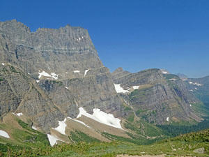
Follow the trail as it makes an ascending traverse through forest and meadows on easy to moderate grades. Openings along the trail offer fine views of Mt. Grinnell (8,851-ft.), the Garden Wall, Angel Wing, Mount Gould (9,553-ft.) and the Grinnell and Salamander Glaciers to the west/southwest.
At 1.1 miles the trail curves into the Cataract Creek Valley. Angel Wing and Mount Gould soar above the valley to the southwest.
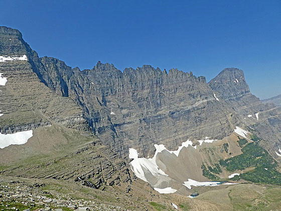
At 1.9 miles the trail descends on easy grades, passing through a lovely meadow. The Garden Wall’s serrated ridge between the Bishop’s Cap (9,127-ft.) and Mount Gould towers above the west side of the valley. Pretty Feather Plume Falls, a tall horsetail style falls, drops down a sheer cliff between Mt. Gould and Angel Wing (7,430-ft.).
At the head of the valley Pollock Mountain (9190-ft.), Piegan Mountain (9,220-ft.) and Cataract Mountain (8,180-ft.) dominate the view. (Piegan Pass is located on the unseen saddle between Piegan and Cataract Mountains.)
Arrive at a junction at 2.2 miles. The trail making a sharp turn to the right (north) leads to Grinnell Lake. We continue straight ahead on the Piegan Pass toward the head of the valley.
The trail now ascends on easy grades through open forest, crossing a bridge over Cataract Creek at 2.3 miles. As you proceed up the valley enjoy more great views of the Garden Wall to the west.
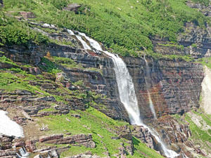
At 2.8 miles the forest gives way lush meadows and willow thickets. The peaks at the head of the valley form a stunning backdrop for Morning Eagle Falls, plunging down a steep cliff. Allen Mountain (9,376-ft.) and a number of lesser peaks rim the valley to the east.
Cross back to the east side of Cataract Creek on a bridge at 2.9 miles. Deep snow often lingers in this part of the valley. It is now unusual to see snow bridges spanning the creek above the crossing. For safety reason do not try to cross the snow bridges.
Beyond the crossing the trail ascends through stunted conifers and meadows on moderate and then easy grades, reaching the base of Morning Eagle Falls at 3.25 miles. Here multiple cascades spill over a ledge and down a red argillite rock face. The jagged cliffs along the Continental Divide tower overhead.
Morning Eagle Falls to Piegan Pass
Distance from Trailhead: 13.0 miles (round trip)
Ending/Highest Elevation: 7,570-ft.
Elevation Gain: 2,640-ft.
From the base of the falls the trail makes a sharp left and starts climbing moderately steep switchbacks through forest and intermittent meadows. Along the way enjoy fine views of Morning Eagle Falls. In season, the meadows along this section of the trail are awash in wildflowers.
At 4.5 miles the trail crosses a tributary of Cataract Creek. Beyond the crossing the trail heads south toward the head of the valley on moderately-steep grades, crossing a few more seasonal creeks along the way.
The path is now above the timberline and enjoys fabulous views of the Garden Wall and the peaks rising above the head of the valley. To the east views open to a valley between Mount Siyeh (9,833-ft.) and Cataract Mountain.
At 5.1 the trail begins climbing switchbacks through pretty meadows up the west facing flanks of Cataract Mountain. Pollack Mountain, Bishops Cap and the jagged ridge of the Garden Wall soar above the west side of the valley. A small tarn lies cradled at the base of the wall.
The meadows give way to talus slopes at 5.7 miles. The trail now ascends a steep switch diagonally across the western flanks of Cataract Mountain. The terrific views of the Garden Wall, extending from Pollack Mountain to Mount Gould, will help take your mind off the stiff climb. As the trail nears the end of the switchback we leave the talus behind and now climb through rocky meadows.
At 6.2 miles the long switchback ends. The trail now turns east and climbs a few more switchbacks to Piegan Pass (7,570-ft.) at 6.5 miles. Cross to the east side of the broad pass for excellent views of Mount Siyeh, Matahpi Peak and the Going-to-the-Sun Mountain.
After taking in the scene to the east, return to the north side of the pass and drop down the trail a short distance (0.1 miles) to the top of the first switchback. Here use trails head west to scenic perches high above the Cataract Creek Valley. Pollack Mountain towers overhead. The Garden Wall along the Continental Divide from Bishop’s Cap to Mount Gould dominates the view to the west. Distant views extend north to Mount Grinnell (8,851-ft.), Mt. Wilbur (9,321-ft.) and Mt. Henkel (8,770-ft.) in the Many Glacier area.
With a prepositioned vehicle, you can continue over the pass, following the Piegan Pass trail as it drops down to Siyeh Bend on the Going-to-the-Sun Road. See the Piegan Pass trail for more information on the trail. Otherwise, retrace your steps back to the boat dock, enjoying the great views of the Garden Wall and Morning Eagle Falls on the return journey.
Note: Piegan Pass can also be accessed from the south along the Going to the Sun Road via a shorter, highly scenic hike. See the Piegan Pass hiking description for more information.
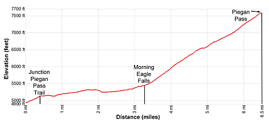
Elevation Profile
Driving Directions
Note: This hike starts at the boat dock at the head of Lake Josephine. Taking the shuttle boat to the start of the hike reduces the hike from 16.8 miles to 13 miles (round-trip) From St. Mary to Many Glaciers: Drive north on US 89 for 8.5 miles and turn left onto Route 3, signed for Many Glacier. The turn is just before the town of Babb, Montana. Continue along Route 3 for 11.4 miles and turn left on the road leading to the Many Glacier Hotel. In a short distance make a second left on the road climbing a hill to a large parking lot in the rear of the complex. Park here and then walk through or around the hotel to the boat dock on the west side of the building.
Shuttle Boat: The Glacier Park Boat Company runs boat tours of Swiftcurrent Lake and Lake Josephine. Hikers can ride the boats either one way or round trip to shorten hiking distances. The two stage boat trip starts from the west side (lake side) of the Many Glacier Hotel and crosses Swiftcurrent Lake. At the end of the lake tour participants disembark and walk 400 yards to the foot of Josephine Lake where a second boat awaits to take the tour to the head to the head of Lake Josephine. At the head of Lake Josephine trails connect to destinations in the Grinnell Valley. See the the Glacier Park Boat Company website for schedules and costs.
Trail Resources
Trail Intro / Trail Photo Gallery / Trail Map
Basecamp(s) Information:
Many Glacier / St Mary
Region Information:
Glacier Natl Park, MT
Other Hiking Regions in:
Montana