Grinnell Glacier 
Distance: 7.2 - 10.4 miles (round trip)
Glacier National Park, near Many Glacier in Glacier Natl Park, MT
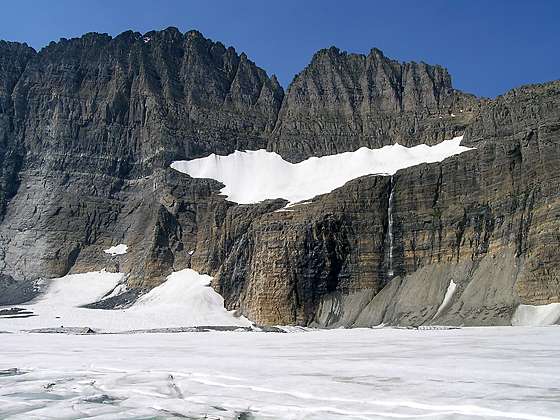
Waterfall emanating from Salamander Glacier tumbling down a cliff and into Upper Grinnell Lake
This popular hike, with fabulous views of the Cataract and Grinnell valleys, climbs through pretty meadows and along rock ledges to Upper Grinnell Lake and Grinnell Glacier, cradled in a dramatic cirque along the Continental Divide.
See Trail Detail/Full Description
- Distance: 7.2 miles (round trip) to Grinnell Glacier
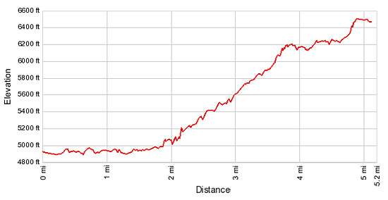
- Elevation: 4,890-ft. at Trailhead
6,510-ft. at Grinnell Glacier - Elevation Gain: 1,620-ft. to Grinnell Glacier
- Difficulty: strenuous
- More Hikes in:
Many Glacier / St Mary / Glacier Natl Park, MT
Why Hike Grinnell Glacier
A dramatic cirque of rugged peaks and jagged ridges, anchored by Mt. Grinnell (8,851-ft.) to the north and Mt. Gould (9,553-ft.) to the south, towers above the head of the Grinnell Valley. Three glaciers, the Grinnell, Salamander and Gem, along with Upper Grinnell Lake lie nestled beneath this imposing wall of rock. The popular hike to Grinnell Glacier climbs the northwestern flanks of Mt. Grinnell to a high bench beneath this stunning cirque, offering fabulous views of the glaciers and Upper Grinnell Lake.
Along the way the trail travels through pretty meadows sprinkled with wildflowers, traverses narrow ledges and enjoys panoramic views of the Cataract and Grinnell valleys. Beautiful Grinnell Falls, fed by glacial melt water, spills down the valley’s headwall to Grinnell Lake, cradled on the valley floor. Good opportunities exist for spotting mountain goats and big horn sheep on the cliffs overhead as well as the meadows below the trail.
Do not expect solitude on the trail. This is an extremely popular hike. During the height of the season large numbers of hikers take the daily ranger led tours visiting the glacier.
Riding the tour boats plying the waters of Swiftcurrent Lake and Lake Joesphine reduces the hiking distance. The round-trip hike via the boat is 7.2 miles compared to 10.4 miles if you walk the trail starting at the Many Glacier Picnic area. During the height of the summer it is best to reserve a seat on the boats the night before.
Check with the Many Glacier Ranger Station for current trail conditions. During heavy snow years the trail may not be open all the way to the glacier. During my last visit to the park trail crews had to blast and hand shovel heavy snow before opening the upper sections of the trail.
Elevation Profile
Trail Resources
Trail Detail/Full Description / Trail Photo Gallery / Trail Map
Basecamp(s) Information:
Many Glacier / St Mary
Region Information:
Glacier Natl Park, MT
Other Hiking Regions in:
Montana