Details: Pierre a Berard Refuge and Col de Salenton 
Distance: 6.6 - 9.4 miles (round trip)
French Alps, near Chamonix in The French Alps
Hike Facts
- Distance: 6.6 - 9.4 miles (round trip)
- Elevation: 4,300-ft. - 6,312-ft.
- Elevation Gain: 2,012-ft. - 3,987-ft.
- Difficulty: moderate-strenuous
- Trail Highlights: See Trail Intro
- Basecamp(s): Chamonix
- Region: The French Alps
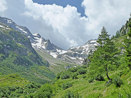
This hike ascends the Berard Valley (Vallon de Berard), a lovely, peaceful vale unspoiled by ski apparatus, to the charming Refuge Pierre a Berard. Beyond the refuge a very steep route climbs up granite outcroppings, boulders and scree to the Col De Salenton.
To Refuge Berard
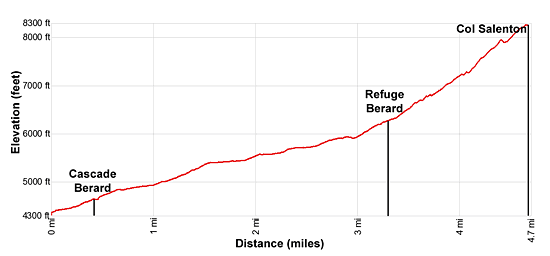
Distance from Trailhead: 6.6 miles (round trip)
Ending/Highest Elevation: 6,312-ft.
Elevation Gain: 1,990-ft.
The trail up the Bernard Valley (Vallon Berard) to the Refuge Pierre a Berard starts on the west side of the D1506 Road across from the SNCF le Buet train station. (See directions below.) Trailhead signs point to Mont Buet and the Cascade (Waterfall) de Berard. There is also a sign displaying a map and brief description of the Reserve Naturelle Vallon de Berard, a nature reserve along the south side of the valley.
Initially the trail rises gently through trees and then rocky meadows along the west side of the Chamonix Valley, reaching the old chalets of La Poya after 0.25 miles. Along the way enjoy views southeast to the Aiguilles des Grands Montets (10,810-ft) and the peaks rising to the north above the Lac Emosson area.
Beyond the chalet the ascent steepens as the trail climbs through forest to a junction at 0.4 miles. Bear right on the trail toward the Cascade (waterfall) de Berard. Soon the trail reaches an overlook above the Berard stream gushing down a rock gorge.
The path now climbs a series of metal steps and platforms cantilevered over the west side of the torrent to a viewing platform where a dramatic waterfall spills down a chute between massive boulders. After viewing the falls, continue climbing steps up the south side of the falls beside the streams cascading down the rocky gorge. Here views open to a small snack bar (La Cascade Buvette) with a wood patio perched atop boulders on the north side of the creek.
Reach a junction at 0.5 miles where the trail to the right (north) leads to a bridge crossing the creek to the snack bar. We continue straight ahead on the trail signed for the Refuges de la Pierre a Berard, Col de Salenton and Mont Buet. (Make note of this junction. To the left is a bypass trail that avoids the metal steps and the gorge, which you might want to use on the return trip down the valley.)
Past the junction, the path briefly travels on a boardwalk along the south side of the creek before resuming a moderate to steep climb on a rocky path through a forest of larch trees. The Aiguille de Loriaz (9,028-ft.), a pyramid-shaped peak, fills the skyline to the northwest.
At 0.7 miles the ascent abates. The path now follows an undulating course through trees above the south side of the creek and soon enters the Berard Valley. This section of the creek is a popular picnic spot frequented by locals looking for a sunny spot to laze away the day. (Make note of the signs warning of the fluctuating water levels in the creek due to flow controls originating at the Emosson hydro-electric project to the northwest.)
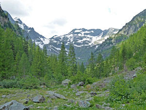
At 1.1 miles the trail crosses the creek on a wood bridge and starts climbing on moderate to moderately-steep grades through trees above the north side the creek. Soon the trees thin and views open to rugged slopes of the Aiguille de Mesure (9,225-ft.) towering above the south side of the valley
At 1.6 miles the path crests the top of a bench where views open to the Aiguille de Berard (8,736-ft.) and the Aiguille du Belvedere (9,728-ft.) rising above the head of the valley. The steep flanks of Mont Oreb (8,642-ft.) soar above the north side of the valley.
The trail now travels up the valley on easy to moderate grades through rocky meadows scattered with trees and shrubs. Along the way enjoy ever evolving views of the high peaks ringing the head of the valley and soaring above the south side of the trail. Waterfalls tumble down side valleys while below the trail the Berard stream winds along the valley floor.
At 2.6 miles the trail ascends along rugged slopes, and then curves to the left (southwest), crossing a small side stream and then a bridged tributary of the Berard stream at 3.0 miles. (As you near the Refuge you will see this tributary is feed via pipe from the Emosson Hydro project.) The last time I hiked the valley a saw a small herd of ibex feeding in the meadows and drinking from the streams.
Beyond the second stream the paths climbs steep switchbacks up rocky meadows sprinkled with alpenrose. The short climbs leads to the top of another bench where views open to the Berard Refuge, strategically build in front of a massive boulder to protect the structure from avalanches.
The grade abates as you approach the refuge. Reach the Pierre a Berard Refuge (6,312-ft.) at 3.3 miles. The privately owned facility feature 40 dormitory places and offers meals, snacks and drinks. From the deck enjoy fine views of the Berard Valley.
To the Col Salenton
Distance from Trailhead: 9.4 miles (round trip)
Ending/Highest Elevation: 8,287-ft.
Elevation Gain: 3,987-ft.
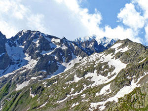
Signs at the Refuge point to the Col de Berard (8,071-ft.), which requires a very steep climb up a permanent snowfield, and to the Col de Salenton. To reach the Col de Salenton (8,287-ft.) ascend northwest on a rugged trail traveling through rocky meadows and rock outcroppings. The very steep ascent, marked by carins and paint marks on rocks, climbs over granite slabs and scree slopes gaining almost 2,000-ft. in 1.4 miles from the refuge. Large snowfields are often present on of the upper slopes well into the summer. Check on current conditions at the Refuge and carry proper equipment if snow is present.
Elevation Profile
Driving Directions
From Chamonix: Take the train (46 minutes) to Le Buet. Walk behind the train station to the car park and then head southwest across the parking lot to the road (D1506). The trailhead is located on the other side of the road between a wood garage (to the right) and a large boulder (to the left). A sign at the trailhead displays a map and brief description of the Reserve Naturelle Vallon de Berard, a nature reserve to the south side of the valley.
For more information on train and bus schedules see the Chamonix Tourist Information site.
Trail Resources
Trail Intro / Trail Photo Gallery / Trail Map
Basecamp(s) Information:
Chamonix
Region Information:
The French Alps
Other Hiking Regions in:
France