Details: Grand Balcon Sud – Planpraz to Flegrere 
Distance: 3.5 - 7.0 miles (round trip)
French Alps, near Chamonix in The French Alps
Hike Facts
- Distance: 3.5 - 7.0 miles (round trip)
- Elevation: 6,562-ft. - 6,800-ft.
- Elevation Gain: 1,410-ft.
- Difficulty: moderate-strenuous
- Trail Highlights: See Trail Intro
- Basecamp(s): Chamonix
- Region: The French Alps
A high level path along the slopes beneath the Aiguille Rouges features nonstop, breathtaking views of Mont Blanc range across the l’Arve Valley. Extend the hike with a trip to Lac Blanc.
Planpraz to Flegere
Elevation Information:
- Trailhead Elevation at Planpraz: 6,562-ft.
- High Point: 6,800-ft.
- Low Point: 5,840-ft.
- Elevation at Le Flegere: 6,090-ft.
- Elevation Gain/Loss: 1,410-ft. / -1,885-ft.
This hike starts with a ride up the Planpraz-le Brevent gondola to the middle station at Planpraz (6,558-ft.) (See directions to the trailhead below). As you exit the lift you will see signs pointing northwest toward Col du Brevent, La Flegere and Lacs (Lakes) Noir and Lac Cornu.
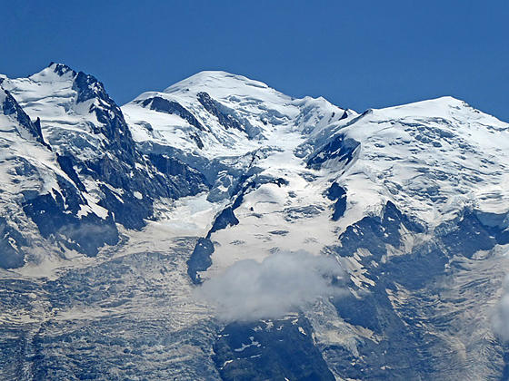
Before starting the hike you’ll probably want to take a brief detour to the overlook in front of the lift station for views of Mont Blanc, Aiguille du Midi and the rest of the Chamonix Aiguilles (Chamonix Needles). The view is partially marred by ski lifts and cables.
Back at the signpost, ascend northwest on moderate to steep grades along a broad track toward La Flegere. The trail winds around a low knoll and up through meadows, passing a restaurant and other ski facilities. Along the way you will probably see parasailers taking off from a grassy slope to the left (west) of the trail.
Reach a junction at 0.3 miles. Bear right (north) on the trail toward La Flegere. You are now on the TMB (Tour de Mont Blanc) and the Grand Balcon Sud. The trail to the left, the continuation of the TMB, climbs to le Brevent. A short distance beyond ignore the path branching left toward Lac Cornu and Lacs Noir.
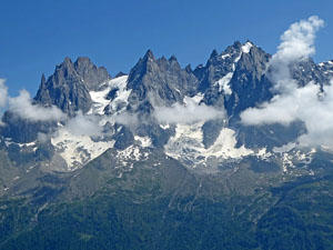
The track now curves to the right (northeast), descending on easy to moderate grades through rocky meadows, rock slides and thickets of alpenrose. The rugged flanks and spires of the Aiguille Rouges (Red Needles) tower above the trail. The walk is accompanied by great views of the Mont Blanc massif and the Chamonix Aiguilles. Of particular note is Aiguille Verte, a massive pyramid-shaped peak soaring above the Mer Glacier valley.
At 0.7 miles the descent steepens. A trail, branching right off the main track, descends on switchbacks and then rejoins the main track just before it crosses a ski service road at a signed junction. On the other side of the ski road the grade abates as the path descends through meadows and short segments of scree.
The trail crosses a second ski service road at 1.5 miles. On the other side of the road the path descends steeply through trees and meadows. Openings offer fine views extending up the Chamonix Valley to Aiguille Vert along with Aiguille de Argentiere and Aiguille du Chardonnet rising above Argentiere Glacier valley.
Reach the low point on the hike at 1.7 miles. The path now curves to the left, ascending steeply in a northeasterly direction through trees. Soon the ascent ends as the trail breaks from the trees and then traverses rocky meadows to a junction at Charlanon, the site of an abandoned alp, at 1.9 miles. At the junction a trail branching left climbs very steeply to the Col et Lac Cornu. We continue straight ahead toward Flegere on the TMB. The rugged slopes of the Aiguille Pourrie and Aiguille Charlanon rise above the trail to the west.
Past the junction a brief climb on easy grade leads to a crossing of a ski service road at 2.1 miles. Beyond the crossing the trail follows an undulating course through scattered trees, meadows and scree covered slopes along the steep eastern flanks of Aiguille Pourrie’s east ridge. To the east/southeast the Chamonix Aiguilles and Mont Blanc form the backdrop for the Chamonix Valley. Aiguille Vert, Aiguille Chardonnet and Aiguille de Argentiere fill the skyline to the northeast.
At 2.8 miles the trail crosses a ski service road and then passes through an opening in a stone wall, part of an avalanche control system. The trail now crosses an avalanche chute below Aiguille de la Gliere. Exit the chute by climbing scree covered slope and then ascending through scatter trees over a low ridge to the La Flegere area. Here views stretch from the Col de Balme, in the northeast, to the Col de Voza, in the southwest. Across the valley are great views of the high peaks soaring above the Mer Glacier Valley.
Reach the Refuge La Flegere, offering accommodations for 90 people along with food and drinks, at 3.5 miles. Above the Refuge is the cable car with service down to the les Praz de Chamonix and a chairlift up to l’Index. The top of the l’Index lift provides access to a high level route leading to Lac Blanc and the Chalet du Lac Blanc. See the Aiguilles Rouges Loop hiking description for more information on this high route. Lac Blanc is also reached on trails to the northeast of Flegere. Again see the Aiguilles Rouges Loop hiking description for more information.
Flegere, like Planpraz, is hardly photogenic, littered with ski lifts, pistes and other ski apparatus. But the views of the high peaks across the valley are sublime. My advice is to continue along the TMB, ascending beyond Flegere for 0.5 miles or so to find a nice spot for lunch, away from the ski slopes.
At Flegere you have a number of options.
- Take the lift down to Les Praz de Chamonix for a 3.5 miles hike Retrace your steps to Planpraz for a 7.0 miles hike
- Take a side trip to Lac Blanc (7,716-ft.), which adds 4.0 miles (round-trip) onto the hike and over 1,600-ft. of elevation gain. See the Aiguilles Rouges Loop hiking description for more information.
Elevation Profile

Driving Directions
From the Chamonix-Mont Blanc Train Station to Le Brevent-Planpraz Lift: Walk to the traffic circle in front of the train station. Walk half way around the circle and then head northwest on the Avenue Michel Croz for 0.2 miles and then turn left onto Rue Joseph Vallot. Walk one block and then turn right onto Place de l’Eglise. The Place de l’Eglise soon becomes the Place du Triangle de l’Amitie as it travels by the Chamonix Tourism Office.
Follow the Place du Triangle de l’Amitie to a traffic circle. Go half way around the circle, essentially straight, and then ascend the Rue la Mollard to the Planpraz-le Brevent lift station. This is a two stage lift with a gondola going to Planpraz (the middle station) and then a cable car ascending to le Brevent. Purchase a round trip ticket on the gondola to Planpraz.
For more information on bus schedules see the Chamonix Tourist Information site.
From the Flegere Cable Car Station to Chamonix: follow the Chemin de ’Ecole to Route des Praz. Turn left left (northeast) on Route des Praz. In a short distance you will arrive at a bus stop. Take the #1 or #2 buses back to Chamonix. There is also a #2 bus that heads up the valley toward Le Tour.
For more information on bus schedules see the Chamonix Tourist Information site.
Trail Resources
Trail Intro / Trail Photo Gallery / Trail Map
Basecamp(s) Information:
Chamonix
Region Information:
The French Alps
Other Hiking Regions in:
France