Details: Les Houches to the Col de Tricot and Mont Vorassay 
Distance: 4.8 - 13.8 miles (round trip)
French Alps, near Chamonix in The French Alps
Hike Facts
- Distance: 4.8 - 13.8 miles (round trip)
- Elevation: 5,890-ft. - 6,955-ft.
- Elevation Gain: 1,065-ft.
- Difficulty: moderate
- Trail Highlights: See Trail Intro
- Basecamp(s): Chamonix
- Region: The French Alps
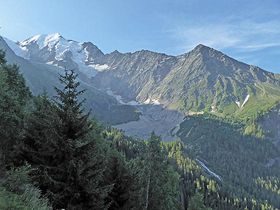
This interesting hike features fine views of Bionnassay and its glacier and Mont Blanc and the southern end of the Aiguille Rouges along with distant views of the Fiz range to the north and the Aravis range to the west.
To Col de Tricot and Mont Vorassay
Purists might want to walk from Les Houches to Col de la Voza on a path gaining 2,650-ft. in about 4 miles (total time 2.25 – 2.5 hours). Unfortunately walking both ways will add 8.0 miles RT to the hike, making for a 13 miles (RT day). If you wish to walk, consider taking the lift up and walking down on the return trip for a 9.0 miles RT hike.
If you wish to walk from Les Houches, find the valley station for the Bellevue Telepherique, located on the south side of the main road through town (see directions below). Walk west from the cable car station and then turn left (south) onto the Chemin du Bonnet. Follow the road up past houses and through trees until you get to a junction signed for the Col de Voza. Turn left on the trail heading to the Col de Voza, which ascends on moderate to steep grades through trees to the Col. From the Col, follow the Tour du Mont Blanc variante (alternate trail) toward the Col de Tricot instead of the main Tour du Mont Blanc trail that heads to Bionnassay.
I recommend taking the Telepherique les Houches-Bellevue and then following the Tour du Mont Blanc Variante (alternate route) toward the Col de Tricot. The lift allows you to save your time and energy for enjoying this great walk with fine mountain views from the Col de Tricot. The ride is quite scenic, with terrific views of the Mont Blanc massif, the Aiguille of Chamonix and the Fiz and Aravis ranges.
Les Houches to the Col de Tricot
If walking from Les Houches, add 4.0 miles (one-way) to the mileage numbers listed in this description.
From the top of the telepherique (cable car) station at Bellevue (5,909-ft.), find a trail sign behind the building and follow the path heading south/southwest toward Col de Tricot, Nid d’Aigle and Chalets de Miage. Note that the Tour du Mont (TMB) icon on the sign includes the word variante is small letters. The variante designation means that this is an alternate route to the main TMB trail that passes through Bionnsaasy.
The trail descends to cross the train tracks (Tramway du Mont Blanc) and then drops steeply to a junction. Views along the way stretch southeast to Mont Blanc, Aiguille de Bionnassay and the Glacier de Bionnasay. At the junction, turn left (southeast) on the trail signed for the Glacier de Bionnassay, Col de Tricot and Nid d’Aigle.
The path now traverses through forest and meadows along the slopes of the ancient lateral moraine of the Bionnassay Glacier, reaching l’Are (5,774-ft.) at 0.7 miles. Here a trail branching right (west) drops down to Bionnassay. We continue toward the Col de Tricot.
At 0.9 miles reach a second junction for l’Are, with trails leading toward the Glacier Bionnassay. We bear right on the trail to Col de Tricot. Opening in the trees offer views of Aiguille de Bionnassay and the Bionnassay Glacier, covered with debris.
After a mile the trail descends through trees and crosses two streams before reaching a swing bridge over the Torrent de Bionnassay, a thundering stream carrying meltwater from the glacier. Beyond the bridge the trail climbs steeply through trees and then meadows toward the Col de Tricot, passing a second trail branching left to Bionnnassay along the way. Views soon open to the Fiz Range to the north. Ahead Mont Verassay rises to the west. Aiguille du Grouter and Bionnassay tower above the glacial valley to the east.
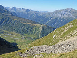
As you ascend turn around for distant views of the Aigulles Rouges. In the middle distance the Tramway du Mont Blanc is seen climbing along the slopes of Mont Lachat.
Reach the Col du Tricot (6,955-ft.) at 2.4 miles. The Col is a grassy saddle located between Mont Veraassay and the west ridge of the Aiguille de Bionnassy. Views from the Col, limited by the steep slopes of Bionnassay’s west ridge, stretch southeast to the glaciers spilling down the Domes de Miage and Aiguille de la Berangere. The Aiguille Rouges and Aiguilles de Chamonix rise in the distance to the north. The Chalets de Miage, nestled in a valley between the Bionnassy ridge and Mont Truc, are seen below the Col. Mont Joly and the Aiguille de la Pennaz tower above the west side of the Val Montjoie.
To Mont Vorassay
For better views, from the Col de Tricot take the path to the right (west) climbing to an overlook atop Mont Vorassay (7543-ft.). The side trip features panoramic views of Bionnassay, the Bionnassay Glacier, Mont Joly and the peaks towering above Montjoie Valley. The very steep climb gaining 600-ft. takes about 30 minutes and is well worth the effort.
When you are done enjoying the Col de Tricot, retrace your steps back to the cable car, for a 4.8 miles RT hike, or walk all the way back to Les Houches for an 8.8 mile hike.
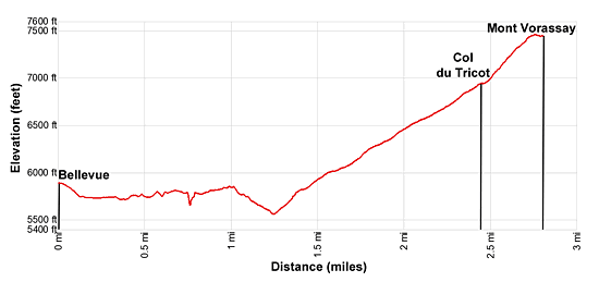
Elevation Profile
Driving Directions
From Chamonix to Les Houches: From Chamonix take the #1 bus to Les Houches and get off at the Bellevue stop. The Cable Car station is located on the south side of the road near the bus stop. If you are walking from Les Houches to Col de Voza, take the #1 bus to Les Houches and get off at the Le Fouilly stop, the next stop after Bellevue. Signs at Le Fouilly will point to the start of the TMB route to Col de Voza.
Trail Resources
Trail Intro / Trail Photo Gallery / Trail Map
Basecamp(s) Information:
Chamonix
Region Information:
The French Alps
Other Hiking Regions in:
France