Details: Sneffels Highline 
Distance: 8.0 - 12.7 miles (loop)
Mount Sneffels Wilderness, Uncompahgre National Forest, near Telluride in Southwest Colorado
Hike Facts
- Distance: 8.0 - 12.7 miles (loop)
- Elevation: 8,900-ft. - 12,280-ft.
- Elevation Gain: 3,380-ft.
- Difficulty: strenuous
- Trail Highlights: See Trail Intro
- Basecamp(s): Telluride
- Region: Southwest Colorado
This is my favorite hike in Telluride. The trail crosses a high saddle separating two gorgeous alpine basins, traverses meadows filled with thigh-high wildflowers and serves up spectacular views of the high peaks surrounding the Telluride Valley and the San Miguel Mountains in the Lizard Head Wilderness.
Trailhead to Saddle
Distance from Trailhead: 8.0 miles (round trip)
Ending/Highest Elevation: 12,280-ft.
Elevation Gain: 3,380-ft.
The Sneffels Highline loop starts and ends at the Jud Wiebe trail at the north end of Aspen Street in Telluride. Completed in 1990, the trail combines existing routes with new trails to create one of the classic hikes in the San Juan Mountains.
Follow the Jud Wiebe uphill as it crosses a bridge and swings west, ascending on a broad track. As you climb views open to downtown Telluride and the ski area across the valley. Reach a trail junction at 0.8 miles after gaining 670-ft. and turn left on the Deep Creek (#418) trail. (The Jud Wiebe trail branches right at the junction.) Cross Butcher creek and, in about 300-ft., arrive at a second junction signed for the Sneffels Highline (#434) and Deep Creek.
I recommend hiking counter-clockwise, turning right (north) on the Highline Trail and returning via the Deep Creek Trail (to the left). While initially steeper, you will get over the high point in the trail early in the day before the onset of afternoon thunder storms, a frequent occurrence in the Rockies.
Follow the Highline as it climbs along the west side (left) of the Butcher creek drainage, passing through stands of aspen, spruce-fir forest and small meadows. Switchbacks ease the moderately steep climb up the drainage.
About 40 minutes from the junction the trail breaks out of the trees and continues its ascent on switchbacks, climbing through grassy meadows to a ridge. From the meadows enjoy views of the ski area and the rugged peaks defining the Bear Creek drainage across the valley. To the southwest the peaks of the San Miguel Mountains in the Lizard Head Wilderness, including Wilson Peak (14,017), Mount Wilson (14,246), El Diente Peak (14,159) and the distinctive profile of Lizard Head Peak (13,113), grace the skyline.
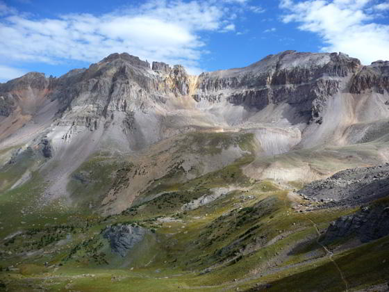
Beyond the meadow the trail continues climbing, passing through a notch to gain the west side of the ridge. Openings in the spruce-fir forest provide views of the steep, eroded hillside of the Pack Basin drainage to the west. A final set of switchbacks through a nice stand of spruce brings you to lower end of Pack Basin (11,750-ft.), a pretty alpine bowl carpeted with an emerald green meadow sprinkled with wildflowers.
The basin is cradled beneath the steep, jagged walls of Mt. Emma (13,581-ft.), rising above the head of the basin, and Greenback Mountain (12,976-ft.) to the south. Behind you are distant views of the San Miguel Range.
A narrow trail, marked by rock cairns, leads through the meadow to the head of the basin where a series of steep switchbacks climb the north wall of the bowl to a saddle (12,280-ft.) on the ridge extending west from Mt. Emma. The saddle, separating Pack and Mill Basins, is reached in just under 4-miles from the start of the hike.
The saddle offers panoramic views of the San Miguel Mountains and Lizard Head Wilderness to the southwest and the peaks rising above the Telluride Ski area to the south. Looking north beautiful Mill Creek Basin is nestled beneath a rugged ridge running between Gilpin Peak (13,694-ft.) and Dallas Peak (13,809-ft.).
Completing the Loop

Distance from Trailhead: 12.7 miles (loop)
Ending/Highest Elevation: 12,280-ft.
Elevation Gain: 3,380-ft.
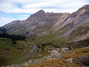
From the saddle the trail descends on rocky switchbacks to the head of the Mill Creek basin and then winds its way past a waterfall and down through meadows, staying to the right (north) of Mill Creek. During the height of wildflower season the trail travels through fields of waist-deep wildflowers at the lower end of the basin.
At the end of the basin the path descends a series of short, tight switchbacks near a waterfall on Mill Creek and then contours along grassy slopes beneath Dallas Peak. After crossing a minor ridge the route climbs 200-ft. through intermittent pockets of trees to the ridge dividing the Mill and Eider Creek drainages. Along the way enjoy beautiful views of Mill Basin, the steep, colorful cliffs lining the east side of the Mill Creek drainage and ever expanding views of the high peaks to the south and east of Telluride.
From the top of the ridge the trail descends on steep switchbacks through pretty stands of aspen to the Deep Creek Trail, losing 900-ft. in 1.3 miles. Turn left (east) on the Deep Creek trail and descend through meadows and trees to another set of steep switchbacks dropping to Mill Creek at 9,900-ft. At this point the trail meets a dirt road. A Deep Creek trail sign points left toward the Jud Wiebe trail and right (south) toward Mill Creek Road. Head left to complete the loop.
The trail soon crosses a bridge over Mill Creek and then heads south following a section of the Deep Creek trail locally referred to as the Waterline Trail because it follows an old water pipe. (Note mountain bikes are permitted on this section of the trail.) A little over a mile after the bridge the route crosses a ridgeline and turns left (east), heading back to the intersection with the Highline trail. From the intersection turn right to reach the Jud Wiebe trail leading back to town.
Total hiking time, including stops, is between 7.5 to 8 hours.
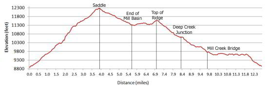
Elevation Profile
| Buy the BookThis opinionated guide includes all the hikes in the Ouray, Telluride, Silverton and Lake City sections of the website plus info on local services and nearby attractions. |
Driving Directions
Walking directions in Telluride: From Telluride’s main street (Colorado Avenue) turn north onto Aspen Street and proceed uphill past the last of the houses to the Jud Wiebe trailhead.
Parking in Telluride: Parking is by permit only at the trailhead and limited to two-hour parking along Colorado Avenue. Permits are required to park on most of the side streets around town.
Free day-use parking is available in Carhenge Lot, just off West Pacific Avenue at the west end of town near the base of Lift 7, or at the south end of Mahoney Drive, near the west entrance to town. A free shuttle bus called the Galloping Goose runs between the parking lots and various stops in downtown Telluride.
There is also free parking in the mountain village. From there you can take the free gondola into town and easily walk to the trailhead.
Trail Resources
Trail Intro / Trail Photo Gallery / Trail Map
Basecamp(s) Information:
Telluride
Region Information:
Southwest Colorado
Other Hiking Regions in:
Colorado