Details: Hawn Mountain 
Distance: 4.9 - 5.0 miles (loop)
Uncompahgre National Forest, near Telluride in Southwest Colorado
Hike Facts
- Distance: 4.9 - 5.0 miles (loop)
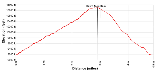
- Elevation: 9,180-ft. - 10,922-ft.
- Elevation Gain: 1,742-ft.
- Difficulty: moderate-strenuous
- Trail Highlights: See Trail Intro
- Basecamp(s): Telluride
- Region: Southwest Colorado
Trail Closed This scenic hike ascends a hand-laid trail to the summit of Hawn Mountain with terrific views of the Lizard Head Wilderness and the high peaks to the east and southeast of downtown Telluride.
Hawn Mountain Loop
The Hawn Mountain trail starts along the Last Dollar Road at the northern entrance to Hawn Lane where a second sign for Hawn Lane is surrounded by a large rock cairn (see driving directions below.) Follow the trail as it begins climbing 13-switchbacks on moderate to moderately-steep grades up talus slopes scattered with trees. One can only imagine the hours of work that went into the hand-laid trail. Flat, platter size pieces of talus are fitted together to form a good, stable path.
On the end of the third switchback reach a signed junction. Here a metal sign points to the left for the “Back of Hawn” trail and right for the “Front of Hawn”/ Hawn Mountain. Make a sharp right turn and continue climbing up the Front of Hawn trail. As you ascend enjoy ever improving views of Wilson Mesa and the high peaks of the Lizard Head Wilderness to the south/southwest.
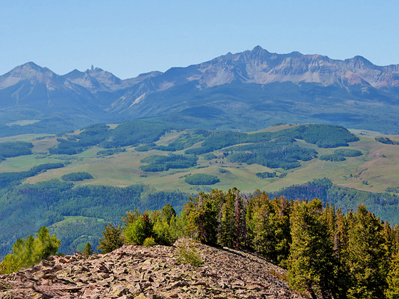
The good trail ends as you reach the ridge crest at 2.5 miles. Lounge chairs, formed by cleverly arranged flat rocks, offer a welcome respite from the climb. From this high vantage point enjoy wonderful views of Sunshine Mountain (12,930-ft.), Lizard Head (13,113-ft.), Wilson Peak (14,017-ft.), Wilson Mountain (14,246-ft.) and El Diente (14,159-ft.) in the Lizard Head Wilderness.
Beyond the “chairs” rock cairns mark the ascent along the ridge crest through trees to the first summit along the ridge at (10,887-ft.). Past the trees the trail continues along the ridge with fine views of Ruffner Mountain (13,003-ft.), Mears Peak (13,496-ft.) and Iron Mountain (12,7474-ft.) rising above the East Fork of Deep Creek to the northeast. Whipple Mountain (11,922-ft.) rises to the north while a sea of summits soaring above Telluride fill the skyline to the east.
Travel along the rocky ridge to the high point of Hawn Mountain (10,922-ft.) at 2.9 miles. Beyond the high point the trail starts descending through trees down the western slopes of Hawn Mountain. Cairns help keep you on track on this lightly trafficked trail. Some openings in the forest offer limited views. The trail swings to the left (southwest) as it crosses Willow Creek and heads down the west side of the drainage. At 4.3 miles the trail crosses to the east side of the creek and soon reaches a junction with a spur trail connecting to the switchbacks with the Front/Back of Hawn sign. Alternatively, continue down the trail as it zig-zags through trees, ignoring the “Stairway to Heaven” trail branching to the right. A few more twists and turns returns reconnects you with the trail near the road at 4.9 miles.
Elevation Profile
| Buy the BookThis opinionated guide includes all the hikes in the Ouray, Telluride, Silverton and Lake City sections of the website plus info on local services and nearby attractions. |

Driving Directions
From Telluride: From West Colorado Avenue and Aspen Street in downtown Telluride, head west on Colorado Ave for 3.2 miles and turn right onto Airport Road/Last Dollar Road. Drive for 1.9 miles to a “Y” intersection, just before the airport, and bear right on the continuation of Last Dollar Road. Airport Road heads east to the Airport Terminal.
Follow Last Dollar Road for another 4.6 miles to the second intersection with Hawn Lane (the second sign for Hawn Lane surrounded by a large rock cairn). Park off the road so as not to obstruct traffic or block the horse trail. Remember the owners of this private property are allowing everyone to use their trail system. Please be considerate and pack out anything you take on the trail.
Trail Resources
Trail Intro / Trail Photo Gallery / Trail Map
Basecamp(s) Information:
Telluride
Region Information:
Southwest Colorado
Other Hiking Regions in:
Colorado