Details: Spring Creek Pass West to Jarosa Mesa 
Distance: 8.8 miles (round trip)
Rio Grande National Forest, near Lake City in Southwest Colorado
Hike Facts
- Distance: 8.8 miles (round trip)
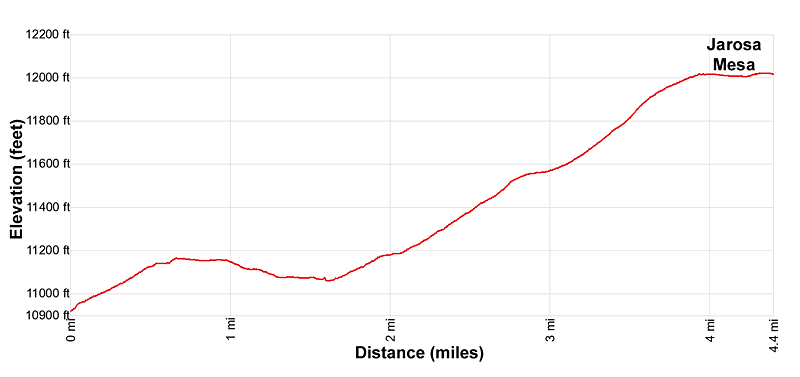
- Elevation: 10,898-ft. - 12-ft.
- Elevation Gain: -10,886-ft.
- Difficulty: moderate
- Trail Highlights: See Trail Intro
- Basecamp(s): Lake City
- Region: Southwest Colorado
Hike a section of the Continental Divide/Colorado Trail from Spring Creek Pass to Jarosa Mesa for great views of the San Juan Range, including Uncompahgre Peak, Matterhorn Peak, Red Mountain, Redcloud Peak and Sunshine Peak.
Spring Creek West
The Continental Divide/Colorado Trails (CDT/CT) to Jarosa Mesa begin at Spring Creek Pass on Highway 149. (See driving directions below.) From the day use parking area, walk along the west side of the campground’s loop road to a dirt road, signed for the Continental Divide/Colorado Trail, heading west. This road is open to vehicles but is seldom used. You are more likely to see a few mountain bikes.
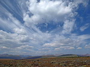
The road ascends on moderately-easy grades through trees to a high point at 0.7 miles. Here the trees give way to meadows and the road now descends on easy grades. Views soon open west to Jarosa Mesa, our destination. To the south/southwest are far-reaching views of the high peaks in the Weminuche Wilderness towering above rounded hills and beautiful valleys. Behind you (east) are ever improving views of Baldy Cinco and Baldy No Es Cinco rising above Snow Mesa.
Reach the low point along the road at 1.6 miles. From here the road now ascends on easy to moderate grades, passing through some trees before coming to a junction at 2.6 miles. To the left is the continuation of the road. We bear right on a signed trail for the CDT/CT.
The trail now ascends on moderate to easy grades across a grassy meadow. To the west are the willow clad slopes beneath Jarosa Mesa. At 3.0 miles the trail swings to the left (west) and climbs on moderate grades up meadows-clad slopes edged by willows. Along the way turn around for more great views of Baldy Cinco and Baldy No Es Cinco to the east.
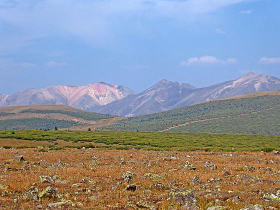
At 3.9 miles the grade abates as the trail reaching the top of Jarosa Mesa. Here stunning views open to the peaks of the San Juan Range. To the west Red Mountain, Redcloud Peak and Sunshine peak towering above the Lake Fork of the Gunnison. Uncompahgre Peak and the Matterhorn grace the horizon to the northwest. Half Peak and a sea of unnamed summits are seen in the distance to the west while the distinctive Rio Grande Pyramid rises above its neighboring peaks in the Weminuche Wilderness to the southwest.
It is now an easy stroll across Jarosa Mesa, accompanied by nonstop views. A good turn around point is located at 4.4 miles, the high point (12025-ft.) on the trail along mesa. Beyond this point the trail starts to descend to a saddle beneath the west side of the mesa.
When you are done enjoying the views, turn around and retrace your steps to Spring Creek Pass for an 8.8 miles round-trip hike.
Elevation Profile
| Buy the BookThis opinionated guide includes all the hikes in the Ouray, Telluride, Silverton and Lake City sections of the website plus info on local services and nearby attractions. |
Driving Directions
Driving Directions from Lake City: From the Lake City Tourist Information Center, at the junction of Gunnison Avenue (Main Street) and Gunnison Street, follow Colorado 149 South for 17.7 miles to Spring Creek Pass. Turn right into the Spring Creek Pass Campground. The day use parking area is located on the right side of the spur road, before you reach the loop for the camping area. The campground includes an outhouse. The Continental Divide trailhead is located at the beginning of a dirt road on the west side of the campground’s loop road.
Trail Resources
Trail Intro / Trail Photo Gallery / Trail Map
Basecamp(s) Information:
Lake City
Region Information:
Southwest Colorado
Other Hiking Regions in:
Colorado