Colorado Midland 
Distance: 6.0 - 7.0 miles (round trip)
White River National Forest, near Leadville in Central Colorado
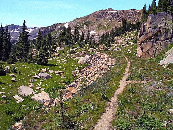
Pretty landscape around the old railroad bed
This hike follows the railroad bed of the first standard gauge line to cross the Continental Divide and ends at the Hagerman Tunnel (11,528-ft.), the highest railroad tunnel in the world at the time it was built in 1887.
See Trail Detail/Full Description
- Distance: 7.0 miles (round trip) to Hagerman Tunnel
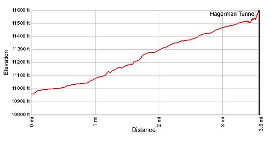
- Elevation: 10,940-ft. at Trailhead
11,528-ft. at Hagerman Tunnel - Elevation Gain: 550-ft. to Hagerman Tunnel
- Difficulty: easy-moderate
- More Hikes in:
Leadville / Central Colorado
Why Hike Colorado Midland
This easy, interesting hike walks along sections of the Colorado Midland railroad bed to Hagerman Tunnel (11,528-ft.), the highest railroad tunnel in the world at the time it was built in 1887. Construction of the line, the first standard gauge line to cross the Continental Divide, is considered by some to be one of the greatest feats in railroad history. Along the way the trail traverses pretty meadows, visits two small lakes and passes the remains of trestles, snow sheds, cuts through solid rock and the ruins of Douglass City, which housed immigrants that built the line.
Elevation Profile
| Buy the BookThis opinionated guide includes all the hikes in the Aspen, Buena Vista, Crested Butte, Marble and Leadville sections of the website plus info on local services and nearby attractions. |
Trail Resources
Trail Detail/Full Description / Trail Photo Gallery / Trail Map
Basecamp(s) Information:
Leadville
Region Information:
Central Colorado
Other Hiking Regions in:
Colorado