Details: McGee Creek to Steelhead and Big McGee Lakes 
Distance: 11.6 - 13.6 miles (round trip)
John Muir Wilderness Area, Inyo National Forest, near Mammoth Lakes in California's Southeastern Sierra
Hike Facts
- Distance: 11.6 - 13.6 miles (round trip)
- Elevation: 7,840-ft. - 10,600-ft.
- Elevation Gain: 2,510-ft. - 2,760-ft.
- Difficulty: strenuous
- Trail Highlights: See Trail Intro
- Basecamp(s): Mammoth Lakes / Bishop
- Region: California's Southeastern Sierra
This long, interesting day hike traverses the beautiful McGee Creek Valley, traveling beneath colorful peaks to two great destinations, Steelhead Lake (10,350-ft.) and Big McGee Lake (10,600-ft.).
Trailhead to Steelhead Lake
Distance from Trailhead: 11.6 miles (round trip)
Ending/Highest Elevation: 10,350-ft.
Elevation Gain: 2,510-ft.
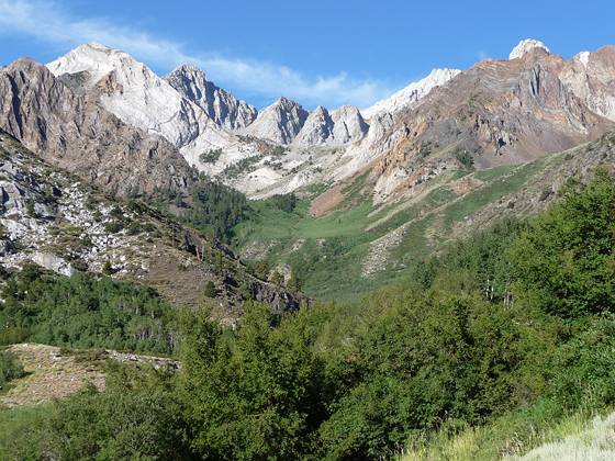
From the parking area follow the trail or the old jeep track as it heads west, ascending along the north side of the McGee Creek valley on easy to moderate grades. To the west, the colorful metamorphic rock of Mt. Aggie (11,561-ft.) and Mt. Morrison (12,268-ft.) fill the skyline. The valley floor is mostly covered with sagebrush and rabbitbrush, but closer to the creek there are also black cottonwood, water birch, copper birch and quaking aspen.
At 0.8 miles the trail crosses a small creek. Just beyond the trail converges with the jeep road at the boundary of the John Muir Wilderness area. As you proceed up the valley the trail curves to the southwest and views open to Mt. Baldwin (12,592-ft.) and Horsetail Falls.
Enter a grove of aspens at 1.5 miles and in a short distance cross two streams carrying water from Horsetail Falls. The trail now curves to the south as it continues heading up the valley through forest on easy grades. Openings in the trees provide nice views of Mt. Crocker (12,458-ft.) rising at the head of the valley.
As you proceed up the valley trees give way to meadows with nice wildflower displays. Open areas provides fine views to the south toward the head of the valley. At 2.6 miles the trail crosses McGee Creek on two logs. Early in the season and during periods of high water the crossings of McGee Creek can be problematic. Exercise caution.
Beyond the crossing the trail continues ascending along the east side of the valley on moderate grades. At the top of a small rise (3.0 miles) the grade eases as the trail travels beside a picturesque beaver pond.
Logs facilitate the second crossing of McGee Creek, 3.5 miles from the trailhead. On the other side of the creek the trail enters the forest, climbing west away from the creek to circumvent a granite outcropping and then curves back to the south. A short distance past the second cross vestiges of the old road break off from the trail. Continue along the trail (branching to the left), following signs for McGee Pass. The old road is used by stock parties headed for Big McGee Lake.
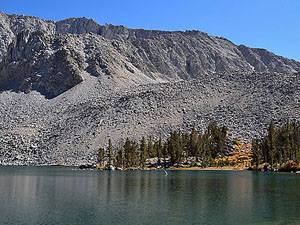
At 4.6 miles reach the junction with the trail to Steelhead Lake, heading left. If you are going to Steelhead turn left (east) and cross McGee Creek on a log. Beyond the crossing a rocky trail climbs steeply up switchbacks to the junction with the spur trail to Grass Lake. Continue straight ahead, following the trail as it crosses a small draw and then ascends steeply up another rocky slope to north end of Steelhead Lake, gaining over 860-ft. from the last crossing of McGee Creek.
Lovely Steelhead Lake (10,350-ft.) is nestled in a granite basin. Steep talus slopes rise above the north end of lake. Views extend south to Mt. Stanford, west to Mr. Crocker and north to Mt. Baldwin. Campsites are located amid the lodgepole pines along the eastern and western shores.
To Big McGee Lake
Distance from Trailhead: 13.6 miles (round trip)
Ending/Highest Elevation: 10,600-ft.
Elevation Gain: 2,760-ft.
If you are heading to Big McGee Lake, take the right fork at the junction. The trail continues heading south up the McGee Creek valley, following an ascending traverse on moderate grades along forested and rocky slopes. At 5.3 miles the trail curves around the south shore of Round Lake and then climbs a series of benches with pretty meadows. Along the way you will start seeing mountain hemlocks. As you ascend, enjoy ever improving views of Red and White Mountain towering above the cirque at the head of the valley. Mt. Crocker rises to the east.
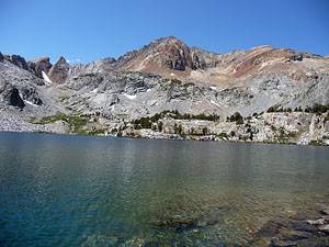
As you approach Big McGee Lake (10,600-ft.) the trail curves to the west and begins climbing rocky slopes north of the lake. Leave the trail at this point and follow one of the use trails leading down to lake shore, 6.8 miles from the trailhead.
Beautiful Big McGee Lake is set amid a backdrop of the colorful Red and White Mountain (12,816-ft.) rising to the west. On the granite ridge to the south is Hopkins Pass, a class 2 route. Camping opportunities around the lake are limited to some exposed sites on the rocky peninsula jutting into the lake.
Beyond Big McGee Lake the trail passes Little McGee Lake and climbs to McGee Pass (11,876’), 9 miles from the trailhead. From the pass the trail descends to Fish Creek and Lake Edison. Total elevation gain from the trailhead to the pass is 4,035-ft. Note there are no campsites between Big McGee Lake and the pass.
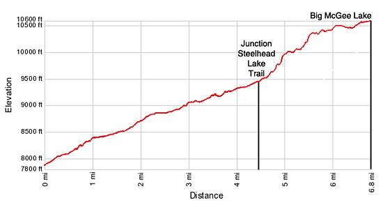
Elevation Profile
Driving Directions
From Mammoth: Head south on US 395 S for 8.6 miles and turn right (southwest) on the McGee Creek Road. Drive 3.3 miles to the end of the road. The last mile is dirt. Park in the paved parking area.
From Bishop: Head north on US 395 N for 30.6 miles and turn left (southwest) on the McGee Creek Road. Drive 3.3 miles to the end of the road. The last mile is dirt. Park in the paved parking area.
Trail Resources
Trail Intro / Trail Photo Gallery / Trail Map
Basecamp(s) Information:
Mammoth Lakes / Bishop
Region Information:
California's Southeastern Sierra
Other Hiking Regions in:
California