Details: Bishop Pass 
Distance: 4.0 - 11.0 miles (round trip)
John Muir Wilderness, Inyo National Forest, near Bishop in California's Southeastern Sierra
Hike Facts
- Distance: 4.0 - 11.0 miles (round trip)
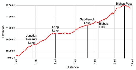
- Elevation: 9,820-ft. - 11,972-ft.
- Elevation Gain: 938-ft. - 2,152-ft.
- Difficulty: moderate-strenuous
- Trail Highlights: See Trail Intro
- Basecamp(s): Bishop / Mammoth Lakes
- Region: California's Southeastern Sierra
This excellent hike leads through a succession of beautiful lake basins to Bishop Pass (11,972-ft.), with spectacular views of Mount Agassiz, the Black Divide and Dusy Basin.
Trailhead to Long Lake
Distance from Trailhead: 4.0 miles (round trip)
Ending/Highest Elevation: 10,758-ft.
Elevation Gain: 938-ft.
Starting from the south end of the trailhead parking area the Bishop Pass trail makes a short descent before it begins climbing at a steady pace along the east side of South Lake (9,768-ft.). The open trail offers wonderful views of the peaks ringing the lakes basin, including Hurd Peak (12,237-ft.), Mt. Thompson (13,494-ft.) and Mt. Goode (13,085-ft.).
A half mile from the start the trail turns left (southeast), passes through a small drainage and then makes a sharp right (southwest) turn back toward the lake. The trail now enters a forest of aspen and lodgepole pines, reaching the border of the John Muir Wilderness at 0.7 miles and the junction with the Treasure Lakes trail at 0.8 miles. Beyond the junction the trail turns left (southeast) and heads away from the lake, continuing its steady ascent.
After crossing a small bridge you may notice an unmarked trail heading right toward Hurd Lake. Reach the marked trail to Marie Louise Lakes, branch left (southeast), at 1.3 miles. Soon the trail crosses a small meadow and then climbs a series of moderately steep switchbacks before reaching a junction with the path to Bull Lake and Chocolate Lake at 1.7 miles. (The Chocolate Lakes trail rejoins the Bishop Pass trail in 1.3 miles.)
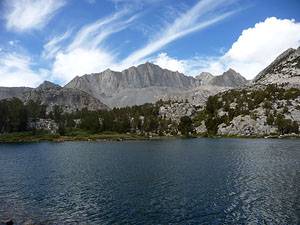
Past the junction the grade abates as the trail traverses a meadow with a scenic tarn. To the east/southeast views open to the jagged peaks of the Inconsolable Range rising above Chocolate Lake. At 2.0 miles the trail arrives at the northern end of scenic Long Lake (10,758-ft.). Hurd Peak towers above the west side of the lake while Mount Goode dominates the view to the south.
Long Lake to Bishop Lake
Distance from Trailhead: 8.2 miles (round trip)
Ending/Highest Elevation: 11,240-ft.
Elevation Gain: 1,420-ft.
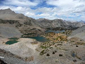
The trail now wanders along the eastern side of the lake for 0.7 miles, along the way passing the junction for the trail to Ruwau and Chocolate Lakes, heading east (left), at 2.6 miles. The grand views of the peaks to the south and west invite frequent stops along the lake shore. The area surrounding the lake is a popular place to camp for people who wish to fish and explore the upper lakes basin.
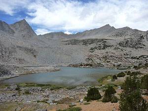
At the south end of Long Lake the trail resumes its steady ascent, traversing a rocky hillside above the eastern shore of Spearhead Lake and then climbing a set of switchbacks. The grade abates as the path reaches the Timberline Tarns in the upper lakes basin. Follow the trail as it curves around the western side of the lower tarn and ascends beside a pretty waterfall to the eastern shore of Saddlerock Lake (11,128-ft.) at 3.6 miles. The lake lies nestled beneath the eastern flanks of Mount Goode in a rocky basin decorated with clusters of stunted whitebark pines.
Follow the trail as it crosses Saddlerock Lake’s outlet stream on a footbridge and parallels its eastern shoreline. At the head of the lake the trail climbs a hill at a moderate pace, reaching Bishop Lake (11,240-ft.) at 4.1 miles. Along the way pass unmarked use trails leading campsites on the north side of the lake.
Bishop Lake to Bishop Pass
Distance from Trailhead: 11.0 miles (round trip)
Ending/Highest Elevation: 11,972-ft.
Elevation Gain: 2,152-ft.
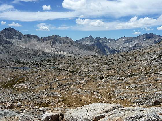
Bishop Lake lies cradled in a dramatic glacial scoured granite basin. Mount Goode and Mount No Goode fill the skyline to the west while the jagged peaks and crags of Mount Agassiz (13,893-ft.) loom above the head of the basin.
The trail to the pass now climbs along the slope above the east side of Bishop Lake. At the head of the lake rock-hop across the outlet stream and begin climbing on moderate grades toward the wall at the head of the basin. Switchbacks ease the ascent up a hillside covered with rocks and small boulders. At 4.6 miles the grade steepens as the trail negotiates a landscape covered in large boulders and huge rock slabs deposited by a 2008 rock slide. As you climb be sure to turn around and enjoy the great views of the Bishop and Saddlerock Lakes basin and the jagged pinnacles of the Inconsolable Range.
At 4.8 miles the trail turns southwest and scales the granite wall on at the head of the basin on steep, rocky switchbacks. Mount Agassiz and Aperture Peak tower above the trail to the east. Near the top of the wall, 5.1 miles from the trailhead, the grade moderates. The final push to the pass ascends a broad plateau through rocky terrain littered with large granite slabs.
From Bishop Pass (11,972-ft.), reached 5.5 miles from the trailhead, views extend southwest to the peaks along the Black Divide towering above the southwest side of Le Conte Canyon. Mt Agassiz rises above the rocky plateau to the east.
For more expansive view I recommend hiking down the south side of the pass toward Dusy Basin for a quarter mile (losing about 100-ft.) to an obvious use trail that heads right just before the trail makes a sharp turn to the left. The use trail leads to a great viewpoint with panoramic vistas of Dusy Basin and the Black Divide.
Beyond the viewpoint the trail descends to Dusy Basin and then drops to Le Conte Canyon (8,756-ft.) on steep switchbacks to meet the John Muir trail, 6.0 miles from the pass after losing 3,216-ft. (To access Dusy Basin exit the trail near the large lake at 11,360-ft.)
After soaking in the views reverse your steps, enjoying the now easy jaunt downhill through the beautiful lake basins.
Elevation Profile
Driving Directions
From Bishop: From US Highway 395 in downtown Bishop, turn west on Line Street /Highway 168. Follow Line Street / Highway 168 for 15 miles and turn left on to South Lake Road. Follow South Lake Road for 7.1 miles to the trailhead, located at the end of the road. Overflow parking is located along the road near Parchers Camp, less than a mile from South Lake. The trailhead is at the south end of the trailhead parking lot, to the left of the bathrooms.
From Mammoth Lakes: Drive 3.1 miles southeast on Main Street / CA 203 E and turn right onto the entrance ramp for US 395 S. Follow US 395 south for 39.1 miles to Bishop and turn right (west) on Line Street /Highway 168. Follow Line Street / Highway 168 for 15 miles and turn left on to South Lake Road. Follow South Lake Road for 7.1 miles to the trailhead, located at the end of the road. Overflow parking is located along the road near Parchers Camp, less than a mile from South Lake. The trailhead is at the south end of the trailhead parking lot, to the left of the bathrooms.
Trail Resources
Trail Intro / Trail Photo Gallery / Trail Map
Basecamp(s) Information:
Bishop / Mammoth Lakes
Region Information:
California's Southeastern Sierra
Other Hiking Regions in:
California