Lizard Head 
Distance: 7.6 - 11.7 miles (loop)
Lizard Head Wilderness, San Juan National Forest, near Telluride in Southwest Colorado
Great views of Lizard Head and the peaks of the San Miguel mountains
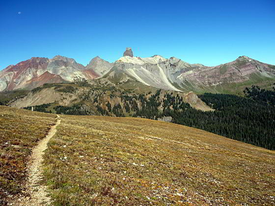
One of the top hikes in the Telluride area, this scenic loop traverses the panoramic spine of Blackface Mountain on its way to the base of Lizard Head Peak (13,113-ft.), an eroded 400-ft. tall spire shaped like the gaping maw of a lizard with its face to the sky.
See Trail Detail/Full Description
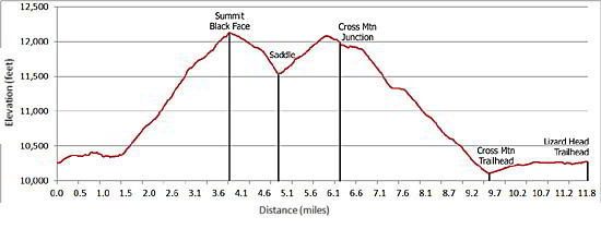
- Distance: 7.6 miles (round trip) to Black Face Peak
- Elevation: 10,250-ft. at Trailhead
12,147-ft. at Black Face Peak - Elevation Gain: 1,897-ft. to Black Face Peak
- Difficulty: strenuous
- More Hikes in:
Telluride / Southwest Colorado
Why Hike Lizard Head
The Lizard Head trail traversing Black Face Mountain’s broad, panoramic ridge is not the shortest route to the base of Lizard Head peak but it is certainly the most scenic. From the ridge leading to the top of Black Face Mountain, the San Miguel Range, including Mount Wilson (14,245-ft.), Gladstone Mountain (13,913-ft.) and Wilson Peak (14,017-ft.), forms a dramatic backdrop for Lizard Head’s lone spire soaring 400-ft. above its rock pedestal.
To the east spectacular views encompass Trout Lake and the peaks surrounding the Lake Hope basin, including Sheep Mountain, Pilot Knob, Golden Horn and Vermillion Peak. To the north Sunshine Mountain rises above picturesque Wilson Meadows. In the distance, to the northeast, is the jagged profile of the Sneffels range.
The trail can be done as an out-and-back hike or a loop using the Cross Mountain trail and the old Railroad Grade route on the return leg. The loop covers 11.7 miles of diverse terrain with a net elevation gain over 2,900-ft.
Be aware the loop hike follows ridges and crosses high alpine meadows for over 4 miles. These areas are dangerous places to be in the event of a thunderstorm. Pick a nice day and get an early start so that you are down from the high country before the onset of afternoon thunder storms, a frequent occurrence on summer afternoons in the Rockies.
Elevation Profile
| Buy the BookThis opinionated guide includes all the hikes in the Ouray, Telluride, Silverton and Lake City sections of the website plus info on local services and nearby attractions. |
Trail Resources
Trail Detail/Full Description / Trail Photo Gallery / Trail Map
Basecamp(s) Information:
Telluride
Region Information:
Southwest Colorado
Other Hiking Regions in:
Colorado